In July of 2021, the NWS began an experimental phase of an Experimental National Geographic Information System (GIS) Map Viewer (“the Viewer”) web application, and since then, we’ve made some changes that’d we’d love to hear from you about!
The Viewer provides capabilities to display, interrogate, access, and discover data and easily assimilates this information so that those familiar with geospatial data and technology can seamlessly access and digest it. The Viewer’s data layers include everything from rapidly updating products (e.g radar) to more traditional products (e.g. forecasts), and from watches and warnings to reference boundaries.
The changes made since the original release in the Summer of 2021 include several functionality releases and bug patches. These enhancements and patches include a table of contents upgrade to include “processing” indicators, addition of individual WWA layers, individual layer opacity controls, performance improvements for time enabled data layers & time slider, updates to many legends, and more.
In addition, the Viewer now has a total of nine program sites accessible in the “Change Site” menu. Work has begun to identify specific data to add to each of these sites. Tropical and Water have the most content at this time. Each of these program sites feature a collection of layers that are most relevant to that program. They include:
The Product Description Document (PDD) for the Viewer details more information about the Viewer, and a public notification statement was issued last week announcing the extension of the comment period and comments are being requested through May 27, 2022. Training is available in the Technical User’s guide (TUG) and a basic demonstration video. Feedback on the GIS Viewer is encouraged as NWS may consider phasing out legacy GIS display platforms once the Viewer becomes operational. The NWS will evaluate all comments during this period and will determine any additional and immediate need for changes based on public feedback. Please provide feedback through this NWS survey.
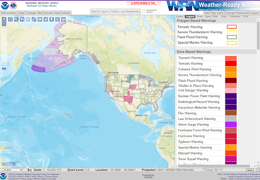
The Viewer on April 20, 2022 with the default data layers for the General landing page.
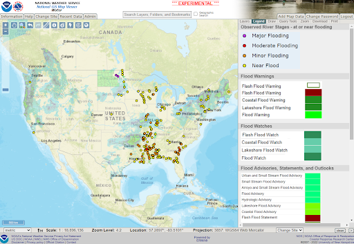
The Water Program Site default layers zoomed to the CONUS on April 20, 2022.

