Date Posted: August 23, 2012
 |
| Dual polarization technology is coming to each of the 160 Doppler radars across the country. |
It’s a Bird! It’s a Snowstorm! It’s a … Flying Barn? NOAA’s Upgraded Radars Now Know the Difference. Bet you didn’t know that when you look at a Doppler radar image, you are seeing more than just rain or snow moving through the atmosphere. In fact, Doppler radars show a mash-up of everything in the sky, from severe weather to birds and mosquitoes to airborne tornado debris. While these radars were a huge meteorological advancement in the early ’90s when NOAA first began using them, the technology left meteorologists with the tough job of sorting out weather from clutter as they developed weather forecasts to warn the public.
But that’s becoming a thing of the past. Doppler radar technology has evolved, thanks to the dedicated work of NOAA researchers who developed dual polarization technology, or dual-pol (pronounced “dual pole”). This new technology helps forecasters distinguish between rain, snow, hail, and other flying objects that muddy the radar picture. The dual-pol upgrade includes new software and a hardware attachment to the radar dish that sends and receives both horizontal and vertical pulses, providing a much more informative two-dimensional picture. The original Doppler radar only has a one-dimensional view.
NOAA’s National Weather Service is half-way through upgrading its network of 160 Doppler radars throughout the nation with this new technology. The dual-pol upgrade is the most significant enhancement ever made to the nation’s radar network since Doppler radar was first installed in the early 1990s. Providing better information about the type of precipitation in the atmosphere and its intensity, size and location, dual-pol radars will increase the accuracy of forecasts and allow for more accurate and timely warnings, giving the public better information to protect their lives and property.
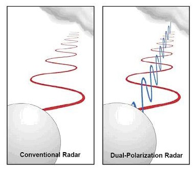 |
| Dual polarization technology gives a 2-D snapshot to forecasters allowing them to see the size and shape of the scanned object. |
Another important benefit: dual-pol more clearly detects airborne tornado debris – allowing forecasters to confirm a tornado is on the ground and causing damage so they can more confidently warn communities in its path. This is especially helpful in the dark when ground spotters are unable to see the tornado.
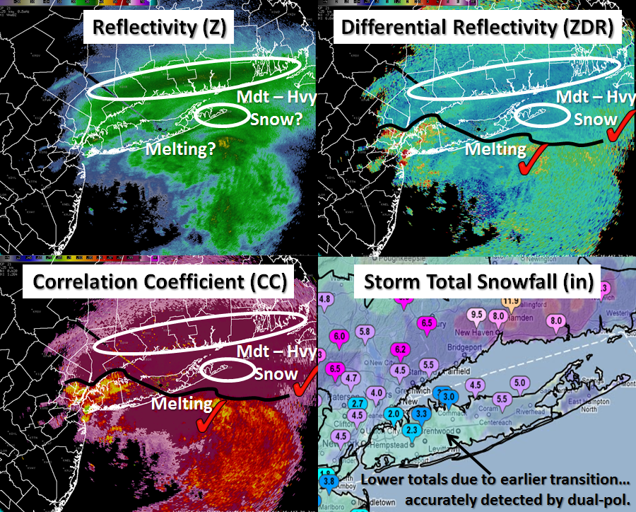 |
| Radar image of a mixed precipitation weather event in New York. Dual-Pol helps forecasters distinguish between rain, snow, hail, and other objects. |
Enhanced confidence in weather forecasts will improve public response to weather warnings, helping to create a more weather-ready nation. Dual-pol radars also could save the nation about 700 million dollars annually by reducing weather-related damages.
Want to learn more? Watch this clever video from NOAA.

