The NWS Doppler radar in Newport/Morehead City, N.C., is currently one of five operational NWS radars to have Dual-Polarization capability. The rest of the 160 federally-operated Doppler radars throughout the nation will be upgraded starting this month through early 2013. Hurricane Irene's landfall was the first time an NWS operational Dual-Pol radar scanned a hurricane. The new data will allow NWS forecasters during land falling hurricanes and inland tropical storm remnants to pinpoint regions of heavy rain and better predict flood and flash flooding.
This is part of the NWS vision to build a Weather-Ready Nation to better protect lives and livelihoods.
Paul Schlatter, who is currently working with NWS Director Jack Hayes in the Office of the Assistant Administrator for Weather Services, said, “One of the benefits of incorporating dual-polarization radar data is for rainfall estimation. The upgraded radar has the ability to far better determine the type and intensity of precipitation, which leads to better estimates of rainfall amounts, which in turn will lead to more accurate flood and flash flood warnings.”
Dual-Pol has the potential for dramatic improvements in rainfall estimation. Still, more testing and refinement is needed for maximum improvement throughout the U.S.
Dual-Pol precipitation estimates for Hurricane Irene in eastern North Carolina seemed to perform better than the existing precipitation estimations, which are based on radar reflectivity alone. In fact, the NWS Newport/Morehead City, N.C., Weather Forecast Office compared both storm total precipitation graphics to their network of rain gauges. Though preliminary, forecasters at the Newport/Morehead City forecast office feel the Dual-Pol product performed better than the older product — in some cases, several inches better.
“This is very encouraging given that this is the first hurricane scanned by an operational Dual-Pol radar in the U.S.,” added Schlatter. He continued with, “The potential for dramatic improvements in rainfall estimation with dual-pol is great, but there is still much testing and refinement to be done so that a maximum improvement is achieved all across the U.S.”
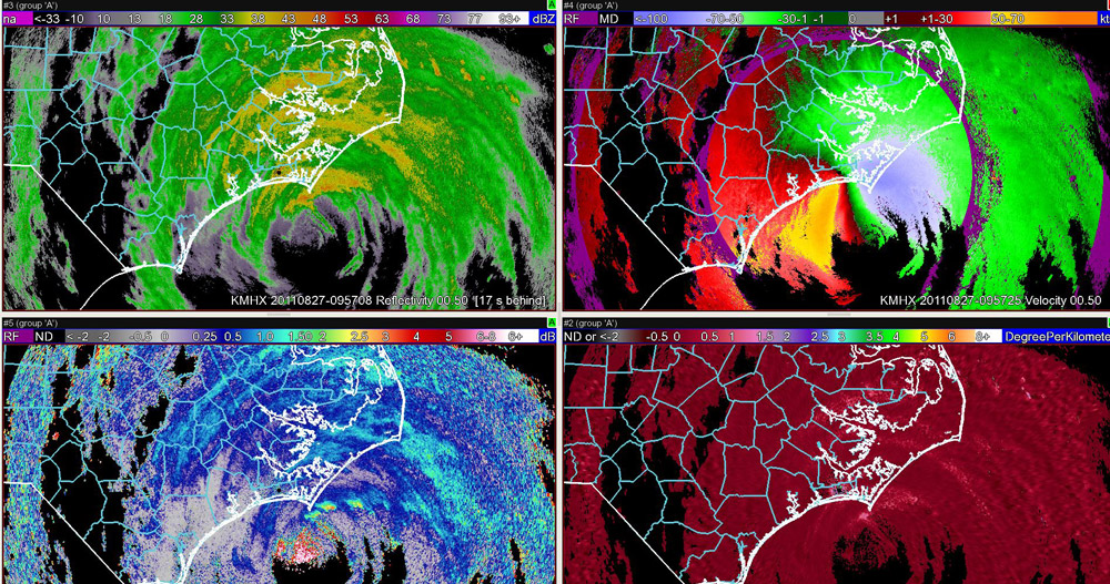
The graphic below shows how the radar gathered information about Hurricane Irene.
Upper left: Reflectivity is a product on existing weather radars that does not change with the upgrade to dual-polarization. Indications of rainfall rates becoming heavier are shown as colors go from green, to yellow, to orange, and finally red. The limitation of this single product is that for the same reflectivity color, rainfall rates can vary widely.
Upper right: The Doppler velocity product is also available on all weather radars and does not change with the upgrade to Dual-Polarization. This image depicts winds moving toward (greens/blues) and away (reds/yellows) from the radar. This image shows 80-90 knot winds a few thousand feet above the ground.
Lower left: The Dual-Polarization product differential reflectivity shows where more intense convective cells are located northeast of the eye. Three blobs of higher differential reflectivity (greens to yellow/red) are just offshore. Rain and winds would be maximized in these smaller regions and forecasters can far better detect their presence with dual-polarization.
Lower right: The Dual-Polarization product specific differential phase greatly improves a forecaster’s ability to detect regions of heavy rainfall, particularly in tropical situations like this one. This product pinpoints regions of heaviest rain, primarily in the outer bands and the north, and northeast part of the eyewall. The pink areas indicate rainfall rates of 1-3 inches per hour, with much lighter rainfall rates in between (burgundy).

