Over the past several decades, Doppler radar has proved to be an invaluable tool to weather forecasters, allowing them to see inside storms to determine where precipitation — be it rain, snow, sleet or hail — is falling, as well as providing the ability to detect rotation in the atmosphere, thus providing important clues as to where tornadoes may be forming. In fact, Doppler radars are so good at detecting what’s in the atmosphere that they detect things that forecasters don’t care to see, such as birds and mosquitoes.
But that’s becoming a thing of the past. Doppler radar technology has evolved, thanks to the dedicated work of NOAA researchers who developed dual-polarization, or dual-pol, technology, which will provide forecasters at each National Weather Service forecast office around the country with new, more-detailed images of what’s happening in the sky, so they can better prepare those on the ground.
 |
|
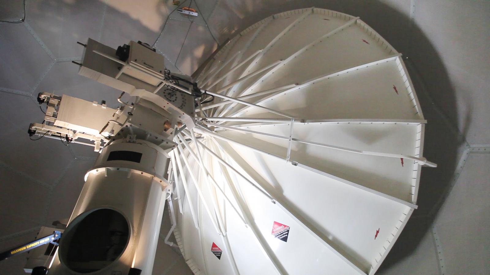
The radar receiving dish inside the protective cover. Dual-pol is both a hardware and software upgrade to the radar. |
The dual-pol upgrades — completed in late April at every NWS-operated Doppler radar in the U.S., represent a NOAA-wide accomplishment. NOAA developed the technology through decades of research at the Oceanic and Atmospheric Research’s National Severe Storms Laboratory, while NWS and contractors designed, tested and installed the upgraded systems and organized timely and relevant training so that forecasters could effectively use the data and technicians could maintain the radars.
The dual-pol upgrade is the most significant enhancement made to the nation’s radar network since Doppler radar was first installed in the early 1990s. Providing better information about the type of precipitation in the atmosphere and its intensity, size and location, dual-pol radars will increase the accuracy of forecasts and allow for more accurate and timely warnings, giving the public better information to protect their lives and property.
The first operational radar upgraded to dual-pol was at Vance Air Force Base near Enid, Okla., on March 8, 2011. As of late April, the NWS has upgraded 151 operational radars. The final site to be upgraded, which is operated by the Federal Aviation Administration and is in Alaska, will be completed this June.
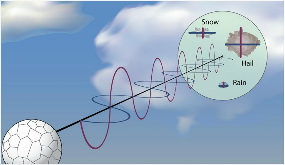
The dual-pol upgrade includes new software and a hardware attachment to the radar dish that sends and receives both horizontal and vertical pulses of energy, providing a much more informative two-dimensional picture. Conventional Doppler radars only send out a horizontal pulse of energy that gives forecasters a one-dimensional picture of whatever is in the air, precipitation or non-precipitation. It can see precipitation, but can’t tell the difference between rain, snow, or hail. Dual-pol radar helps forecasters clearly identify rain, hail, snow or ice pellets, and other flying objects, improving forecasts for all types of weather.
Another important benefit: dual-pol more clearly detects airborne tornado debris — allowing forecasters to confirm a tornado is on the ground and causing damage so they can more confidently warn communities in its path. This is especially helpful in the dark when ground spotters are unable to see the tornado.
Among the success stories already emerging from NWS Western Region offices, the NWS Phoenix forecast office relied on the new dual-pol technology to successfully forecast a very large dust storm that moved across the Phoenix metro area during the late afternoon and evening hours of July 5, 2011. There were widespread reports of near-zero visibility and winds gusting to over 50 mph. Radar data estimated this dust storm reached a peak height of at least 5,000 to 6,000 feet, with a leading edge stretching close to 100 miles and traveling a distance of at least 150 miles.
As the storm approached, dual-pol products helped differentiate rain and dust, and allowed forecasters to track the arrival of the dust storm, as well as confidently track its movement. This storm was, as noted by many residents, one of the largest dust storms Phoenix had seen in the past 30 years.
Dual-pol has also already proved to be successful in saving lives. For example, on February 10, 2012, an EF-4 tornado tore through Hattiesburg, Miss., leaving devastating damage behind. Yet, no lives were lost. Why? It was because of dual-pol technology. It was the first major severe weather and heavy rain episode since dual-pol radar was installed in Jackson. While a large tornado was moving across Lamar County toward Hattiesburg, dual-pol radar products from NWS Jackson and NWS Mobile, Ala., detected debris in the air. NWS Jackson staff were getting visual reports from storm chasers of a tornado. While very helpful, the fact that staff could see on their radar screens that debris was being lofted high up into the storm helped them determine that they were dealing with a particularly powerful tornado.
Back in August 2011, the NWS Doppler radar in Newport/Morehead City, N.C. — one of the first five operational NWS radars to have dual-pol technology — provided forecasters with unprecedented views of Hurricane Irene as it moved over the Outer Banks. It was the first time a hurricane had been scanned by an operational dual-pol radar. The dual-pol precipitation estimates for Irene in eastern North Carolina seemed to perform better than the existing precipitation estimations, which are based on radar reflectivity alone. In fact, the NWS Newport/Morehead City forecast office compared both storm total precipitation graphics to their network of rain gauges. Preliminary results after the storm showed that the dual-pol product performed better than the older, conventional measurements — in some cases, by as much as several inches.
 |
|
Dual-pol data shows what type of precipitation is falling based on its shape. |
On January 19, 2012, forecasters at the NWS Seattle, Wash., forecast office were in the midst of dealing with a major winter weather event across the Pacific Northwest. The event ended up being the worst ice storm in decades for the Seattle area, producing accumulations of ice across a large portion of western Washington, with some locations coated with an inch of glaze. Prior to the upgrade to dual-pol, this would have been a particularly challenging short-term forecast, as conventional radar data offered little insight into the complex distribution of precipitation type.
The correlation coefficient and the differential reflectivity products available with dual-pol radars were instrumental in tracking the movement of this transition zone. Forecasters were able to monitor the dual-pol products and continually update city and county officials, the media and the public on the evolving situation via updated forecasts and warnings, interviews, and instant chat messaging
More recently, an unexpected extreme rainfall event occurred on August 25, 2012, across southeast Virginia, northeast North Carolina, and the lower Maryland Eastern Shore. The event unfolded as an upper low — moving north from the Southeast Coast to the Mid-Atlantic region — tapped into moisture from Tropical Storm Isaac. Dual-pol rainfall estimates were far superior to legacy precipitation estimates and were vital as forecasters at the NWS Wakefield, Va., forecast office reacted to a rapidly-developing situation during the early morning hours of August 25, when several locations experienced urban flash flooding, due to rainfall rates as high as 4-5 inches per hour.
Dual-polarization radar has the ability to far better determine the type and intensity of precipitation than its conventional Doppler radar counterpart, which leads to better estimates of rainfall amounts, which in turn can lead to more accurate flood and flash flood warnings.
At the NWS Boston forecast office, forecasters have made dual-pol radar products part of their routine assessment of various weather scenarios. During the cool season, for example, dual-pol radar products have become an important part to help discriminate precipitation type. A good example of this occurred on November 7-8, 2012, as a coastal storm brought snow to much of interior southern New England and rain to coastal locations. During the afternoon and evening, a coastal front set up across Rhode Island and eastern Massachusetts. Snow fell to the west of the boundary, where temperatures fell into the 30s, while rain fell to the east, where temperatures held in the 40s. Relying on the dual-pol radar’s various products, NWS forecasters were able to clearly identify the rain-snow line, just northwest of the radar’s location. The dual-pol products allowed forecasters to accurately track the slow, southward progress of the rain-snow line that evening, which helped them provide effective short term forecasts to decision makers.
On January 21, 2012, one day after the completion of the dual-pol upgrade at the NWS New York, N.Y., forecast office, the radar sampled a significant winter storm that impacted the Tri-State region. A mixture of snow, sleet, and freezing rain fell across the area, with portions of Connecticut receiving more than 10 inches of snow. Across Long Island, much lower snowfall totals were reported, with 2 to 3 inches falling across western Long Island and 4 to 6 inches reported across eastern sections of the island. The lower totals in western Long Island were largely a result of the snow transitioning to sleet and freezing rain earlier in the day, something the forecasters, using the dual-pol products, accurately captured to aid them in providing more accurate information to the public.
In support of this technology upgrade, the NWS Warning Decision Training Branch has developed on-line training to help NWS partners learn about the system changes and provide ideas on how they might effectively incorporate these new data into their decision making process. Two different training paths are available depending on your meteorology background:
Dual-polarization radar represents one of the most exciting technological advancements available to forecasters today. It’s a success story that illustrates the payoff of long-term investment in federal research. The stories we are already hearing from NWS offices show how the technology is helping forecasters in their efforts to save lives and property. As our nation becomes increasingly vulnerable to weather, the investment made in upgrading our network of Doppler radars to dual-pol technology will result in incalculable returns in terms of saving lives and property and building a Weather-Ready Nation.
PRESENTATION: Dual-polarized Doppler Radar Success Stories [pptx]

