 |
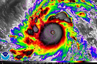
| Super Typhoon Haiyan off the Southeast Guiuan coast, 20:57Z, November 7, 2013 |
With the devastation of Super Typhoon Haiyan in early November of 2013, many asked the question – how does the U.S. National Weather Service (NWS) play a part in world weather events? Although some might suspect very little, given that weather impacts often occur thousands of miles away from mainland U.S., that isn’t quite accurate. In fact, the NWS numerical weather prediction (NWP) system played its part in the global numerical weather models that tracked Super Typhoon Haiyan.
The NWS has strong ties to the World Meteorological Organization (WMO), which is a specialized agency of the United Nations and is the “UN system's authoritative voice on the state and behavior of the Earth's atmosphere, its interaction with the oceans, the climate it produces and the resulting distribution of water resources.” There are 191 Member countries in the WMO, and the U.S. is one of them. Typically, each Member country designates its National Meteorological Service (NMS) as the lead weather entity representing the country – the NWS serves that role for the U.S.
The NWS’ National Centers for Environmental Protection (NCEP) also provides global deterministic and ensemble numerical weather prediction, along with seasonal and climate numerical prediction. Through that role, NCEP has been designated by the WMO as a Global Producing Center for Long-Range Forecasts (GPC-LRF), one of only twelve designated in the world. In addition, it’s important to note the U.S. participates in the World Weather Watch (WWW) – the core of the WMO Programmes – which combines observing systems, telecommunication systems, and data-processing and forecasting centers - all operated by its Members - to make available meteorological and related environmental information needed to provide efficient services in all countries. NCEP’s global model outputs, along with NWS data sharing through the WWW, helped to forecast Typhoon Haiyan.
How does this work? The WMO has a cascading forecasting process, which starts with its Global Data Processing and Forecasting System (GDPFS). GDPFS is the world-wide network of centers operated by WMO Members, with the purpose to make available among WMO Members agreed products and services for applications related to weather, climate, water and the environment.
Two other NWS centers that fall under GDPFS are the National Hurricane Center (NHC) and Central Pacific Hurricane Center (CPHC), which are designated by the WMO as two of the six Regional or Specialized Meteorological Centres (RSMC) around the world that specialize in tropical cyclone forecasting and warning related services. RSMCs are the next cascading level of the forecasting process where information from the GPC-LRFs is interpreted and prepared for daily guidance products during severe weather events. This guidance is then distributed to National Meteorological Centers (NMCs). The role of the NMCs is to issue alerts, advisories, and severe weather warnings to public as the official voice of each Member country. The NMCs are the last level in the cascading forecast process.
In the case of Typhoon Haiyan, it was the Japan Meteorological Agency (JMA) which operates RSMC Tokyo for providing the Philippines and Vietnam with tropical weather guidance, which was initially constructed from the global GPC-LRFs numerical weather data. JMA acts just like the NHC or CPHC when it comes to providing regional tropical weather guidance for impending tropical storms. The only difference is their areas of responsibility (see Figure 1):
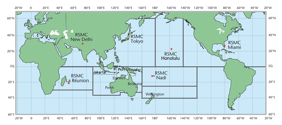
Figure 1 – This map shows all six of the RSMCs that are responsible for delivering tropical weather guidance and the areas that they serve.
The WMO’s cascading forecasting process serves as a coordinated effort that allows countries, especially developing countries and Least Developed Countries who typically can’t run their own forecast models, to add value to the regional forecast guidance provided by the RSMCs for their specific area.

