The National Weather Service (NWS) worked with local communities to save lives and property during December flooding in the Pacific Northwest.
Record rainfall impacted the Pacific Northwest from December 7 - 11, 2015. Portland received 2.67 inches of rain on Monday, December 7, which is a calendar day record for the month of December. Some coastal mountainous regions of the Pacific Northwest received up to 18 inches of rainfall throughout the entire storm. The storm impacts spanned from small stream and river flooding, coastal flooding, and multiple landslides.
Johnson Creek flooded streets and homes in Portland. Several residents living along the creek evacuated. Preliminary analysis indicates the flood was the highest on record in terms of river height (i.e. stage) and discharge (i.e. flow).
 |
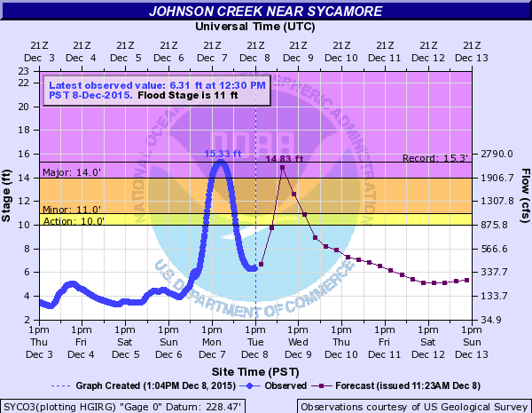 |
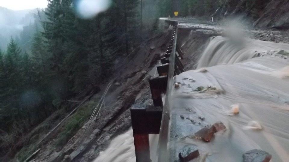
| Highway 12 west of White Pass in Washington. Photo courtesy of Washington State Department of Transportation | NWS AHPS hydrograph showing river forecast (purple trace) produced by the Northwest River Forecast Center. The forecast provided advanced warning for emergency managers and residents to take preventive action. The historic crest of 15.33 feet is shown on the hydrograph along with the observations (blue trace). |
Weather Forecast Office (WFO) Portland provided Decision Support Services (DSS) for this event beginning Friday, December 4. This included daily partner email briefings, webinars and social media messages - all designed to help emergency managers and local officials keep citizens safe in the face of extreme weather.
DSS briefings were provided for the US Coast Guard and Columbia Bar Pilots for maritime safety and commerce. As a result of these DSS briefings, the Columbia Bar Pilots and US Coast Guard were able to allow a few ships to pass when seas and winds temporarily subsided, reducing the impacts to shipping and commerce.
In addition, NWS meteorologists conducted live interviews with The Weather Channel to inform the public about flood hazards. Numerous flood-related warnings and advisories, wind advisories/warnings and marine warnings were also issued by NWS offices in Portland and Seattle.
Briefings provided by WFO Seattle resulted in the evacuation of a juvenile detention center located in a low-lying area near Grays Harbor, Washington. Water as a result of a combination of high tides, heavy runoff from the Chehalis River and high surf ended up covering the center's parking lot and reached the center's doorstep.
Ocean Shores, Washington, also experienced coastal flooding and erosion. A damaged abutment left part of the city vulnerable to high tides and high surf. Pre-arranged DSS email briefings provided key information when high water conditions were met, enabling authorities to mitigate the threat at the vulnerable site.
The event demonstrated the value of the DSS provided by the NWS leading up to and during an episode of historic rainfall and flooding. Briefings, forecasts, and other DSS provided by WFOs Portland and Seattle assisted in evacuation decisions and life and property being saved. These WFOs worked with their emergency management partners and communities to build a more Weather-Ready Nation.
What You Can Do
It is NEVER safe to drive or walk into flood waters. Each year, more deaths occur due to flooding than from any other thunderstorm-related hazard. A mere six inches of fast-moving flood water can knock over an adult. It takes just twelve inches of rushing water to carry away a small car, while two feet of rushing water can carry away most vehicles.
Stay safe and remember: Turn Around, Don’t DrownⓇ.

