Flooding caused by ice jams can be a major problem in Alaska during the spring months. During this “breakup” period, communities along the river are at risk. The Alaska Pacific River Forecast Center works to protect these communities with vital forecast information.
Spring is an apprehensive time of year for communities located along major Alaskan rivers. In a matter of hours, a pleasant spring afternoon can turn into a dynamic river breakup with water levels rising rapidly. Every year, the Alaska Pacific River Forecast Center issues a spring breakup outlook and then works with the State of Alaska to closely monitor the progression of breakup through an annual project called ‘River Watch’.
APRFC issues a breakup outlook in early to mid-April, providing residents and agencies a preview of what can be expected later in the month when large Alaskan rivers begin the transition from ice-covered to open water. The three main ingredients that go into the spring breakup outlook are snowpack conditions, ice conditions and forecast spring temperatures. This year, in early April, the snowpack in Alaska ranged from near normal snow water equivalent to below average in many locations. The valley bottom snowpack in the upper Yukon basin melted much earlier than normal. Ice conditions throughout the state have been reported as normal to below normal thickness, with many observers reporting weak ice much earlier than normal. Forecast temperatures are expected to continue above average statewide through the end of April and into May.
The lack of snow blanketing our river ice, combined with above average temperatures, is expected to lead to an early breakup on most rivers in Alaska. The likelihood of flooding has been rated as low to moderate in most areas of the state. Even when rated as low, flooding is still possible. During a recent spring breakup outlook briefing, one local community member spoke up and said, “Never turn your back on a river during breakup.” This was a timely and much appreciated statement. History has taught us that even during years when the breakup outlook trends towards a more benign river breakup, ice jams resulting in flooding have occurred.
One exception to the low to moderate flood potential in the early April outlook was on Alaska’s North Slope, where a large aufeis (German: literally “on ice” or “top ice”) field has developed on the Sagavanirktok (Sag) River. Similar ice conditions and rapid snowmelt in 2015 lead to closure of the Dalton Highway, interrupting critical shipments to petroleum production facilities on the North Slope. Aufeis, also referred to as naleds (Russian) and icings, is a hydrologic winter process that occurs in arctic and subarctic streams and rivers. In sub-freezing temperatures, water under pressure flows out on top of the ice where it subsequently freezes, adding to the thickness of the ice in the channel and floodplain. The early April outlook rated the likelihood of spring breakup flooding on the Sag River as moderate to high. APRFC is tracking the aufeis field using various satellite products and has been meeting with Alaska Department of Transportation on a regular basis in preparation for breakup on the North Slope.
With the initial outlooks issued and warm temperatures on the way, River Watch kicks into high gear and monitoring begins.
The APRFC has monitored breakup of rivers throughout Alaska for over three decades using two primary sources of information: field reconnaissance and a citizen-based observational network. During the past decade, satellite images have become an additional resource for breakup information. The field reconnaissance is conducted in cooperation with the Alaska Division of Homeland Security and Emergency Management (ADHSEM), which is the agency responsible for the overall direction of the State of Alaska's flood preparedness, response, and recovery program. Typical information obtained during aerial reconnaissance includes the timing of stage crest at a village, a subjective assessment of the likelihood of ice jamming, and breakup activity up or down the river. This information is included in formal flood watches and warnings, as well as communicated directly to village officials by the field staff. The role of ADHSEM during breakup is to promote mitigation activities by local residents in flood-prone villages prior to ice breakup, and to be on hand for immediate emergency coordination if a village is flooded.
Current breakup conditions can be found at: https://aprfc.arh.noaa.gov/
 Figure 1. Breakup status and river conditions are tracked throughout Alaska. Information gathered from local residents, pilots , satellites and NWS staff flying aerial reconnaissance are all summarized in this easy to understand graphic. Figure 1. Breakup status and river conditions are tracked throughout Alaska. Information gathered from local residents, pilots , satellites and NWS staff flying aerial reconnaissance are all summarized in this easy to understand graphic. |
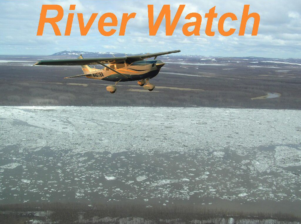 Figure 2. Each spring NWS Alaska Region, in conjunction with the State of Alaska, head out in small aircraft to track river break up activity and issue timely warnings and watches as conditions warrant. Figure 2. Each spring NWS Alaska Region, in conjunction with the State of Alaska, head out in small aircraft to track river break up activity and issue timely warnings and watches as conditions warrant. |

