January 29, 2021 - NOAA’s Nearshore Wave Prediction System (NWPS), which provides on-demand, high-resolution nearshore wave model guidance to U.S. coastal Weather Forecast Offices (WFOs), is undergoing significant upgrades today.
As a part of this upgrade, the model will introduce the first-ever hourly probabilistic hazardous rip current guidance up to six days out for the U.S. East and Gulf Coasts, Puerto Rico, Hawaii and Guam. This new guidance was developed in partnership with the U.S. Lifesaving Association and validated through lifeguard observations of rip currents. These enhancements will undoubtedly help save lives and protect property, as rip currents account for more than 100 deaths in the U.S. each year and 80 percent of rescues performed by beach lifeguards.
 |
 |
|
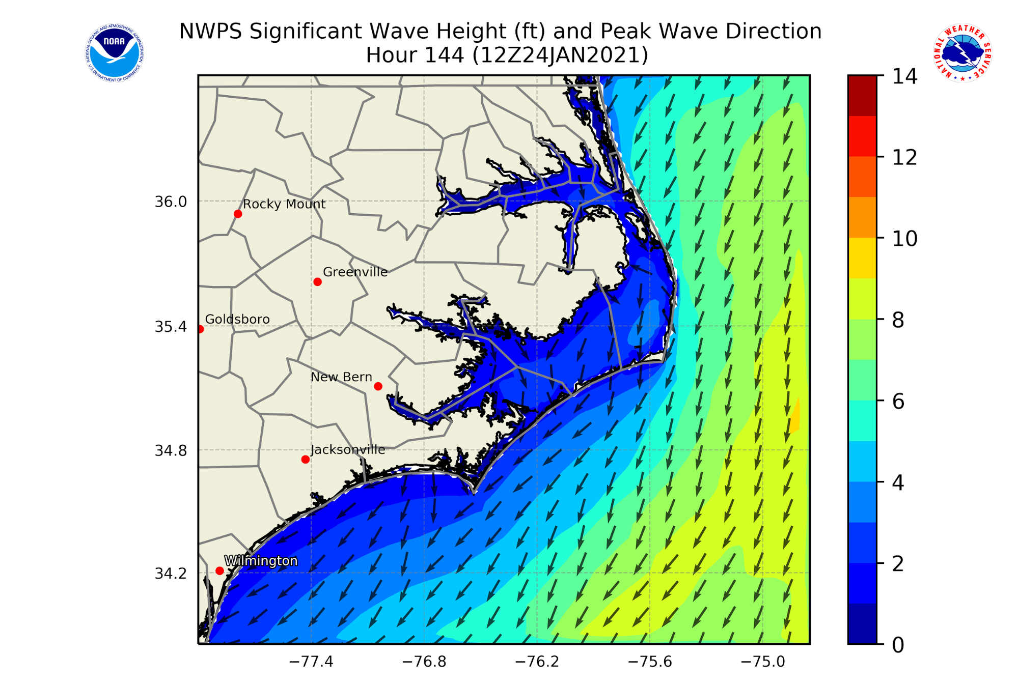
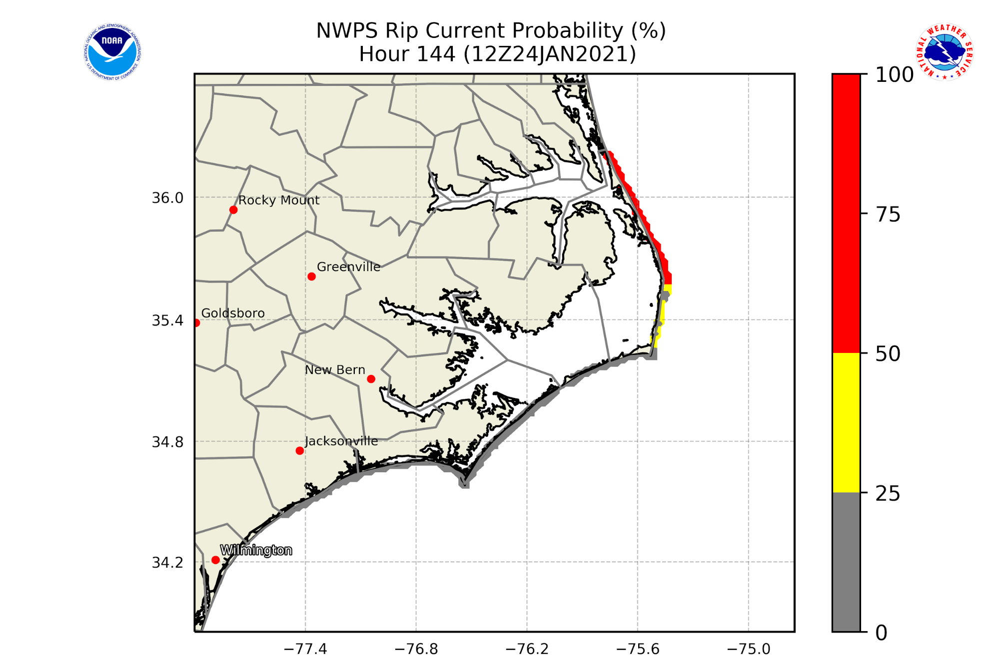
Left: Fig. 1: Snapshot of predicted ocean wave field for Morehead City, North Carolina. The significant wave height (shown in colors) is the average of the highest one-third of occurring waves over a given period. This corresponds to the wave height that would be estimated visually by a mariner. The peak wave period (shown in arrows) is the direction towards which the waves of the highest energy are moving. Right: Snapshot of a hazardous rip current prediction along the coast of Morehead City, North Carolina, which corresponds to the wave conditions shown in Fig. 1. Note: Red contour indicates an exposed region with a greater than 50% chance of encountering a rip current of sufficient strength that would be dangerous to the average swimmer. Gray contour indicates a sheltered region where the probability of encountering a hazardous rip current is lower. |
|
Version 1.3 will also introduce the first-ever hourly probabilistic erosion and overwash guidance for up to six days out for the U.S. East and Gulf Coasts. This is significant because coastal erosion is responsible for roughly $500 million in coastal property loss in the United States each year.
Additionally, the upgrade includes an enhanced wave system identification method, an improved view of wave guidance along high-impact tracks, and a new modeling approach for 12 coastal WFO domains to allow better representation of coastal geography and nearshore wave growth and propagation.
NWPS is developed and maintained by the National Center for Environmental Prediction’s Environmental Modeling Center in collaboration with marine forecasters at the 36 coastal NWS WFOs, as well as partners at the Meteorological Development Laboratory, NOAA’s National Ocean Service, and the United States Geological Survey. The model is driven by forecaster-developed wind grids produced in the Advanced Weather Interactive Processing System, and boundary conditions from the operational WAVEWATCH III model.
The forecasting improvements enabled by this upgrade to NWPS will make way for better protection of life and property at sea in the U.S. East and Gulf Coasts, Puerto Rico, Hawaii and Guam. The next model version will include enhancements for the Western and Alaska Region coastal WFOs.
For more information about changes to the NWPS model, take a look at this Service Change Notice.

