 |
FV3 is able to resolve the path of storm systems on the scale of counties.
NOAA is developing its next generation global prediction system, and at its heart is the Finite Volume Cubed-Sphere dynamical core (FV3) modernizing the National Weather Service’s approach to weather modelling.
A dynamical core takes equations describing movement in the atmosphere, such as moisture traveling through the water cycle, and translates them into computer-solvable language. It’s the engine of a weather forecast model , tracking how the Earth’s atmosphere is changing and what weather might develop as a result, but it doesn’t have all the parts needed to make a forecast. Every model needs three fundamental pieces: a dynamical core, a set of physics equations representing weather processes, and data about the real atmospheric conditions before forecasting.
The complexity and scope of numerical weather prediction means supercomputers are also essential to forecasting. And as computer power increases with each new generation, weather models improve exponentially alongside them.
The National Weather Service’s current Global Forecasting System (GFS) has been the foundation of our suite of weather models for over 30 years. But throughout that time, technology has improved and scientists have found new approaches to processing data. NOAA Research has taken the steps to replace the GFS’s components with newer, more efficient and more accurate processes.
FV3 is the first step. It was developed in NOAA Research’s Geophysical Fluid Dynamics Laboratory initially to power climate models and was then adapted for detailed global weather prediction. The NWS chose FV3 as the new GFS’s dynamical core in part because it uses less computer resources than other options. FV3 brings unprecedented accuracy to forecasts in three important ways:
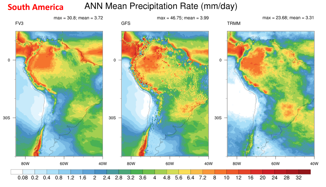 |
| A comparison between the current GFS and FV3 modelling annual mean rainfall across South America. The results from the Tropical Rainfall Measuring Mission (TRMM) show what actual values were. FV3 can resolve small-scale features without the dot-like distortion current GFS shows, which represents false storms. |
NWS and NOAA Research scientists are phasing in the GFS with FV3; it is being run experimentally with the target of going operational in 2019. Our new global model aims to deliver better, more timely forecasts to serve the growing needs of our forecasters and the weather enterprise.

