On this page you learn what types of flooding are typical in Hawaii and how do you protect yourself, your family and your home. You will also find out more about significant Hawaii floods. Finally, you'll find links to NWS offices that provide forecast and safety information for Hawaii, as well as links to our partners who play a significant role in keeping you safe.
In late October 2004, an upper level low pressure system destabilized the lower level trade wind air mass and produced wet conditions across the main Hawaiian Islands, resulting in several flash flood events. One of these floods occurred in the early evening hours of October 30, 2004, as a thunderstorm moved onshore from the east-northeast over the Koolau Mountains and into Manoa Valley. Intense rainfall, with peak rates of 1.29 inches in 15-minutes and 8.71 inches in 6 hours, caused Manoa Stream to quickly overflow its banks in several areas. The worst flooding occurred when a debris-clogged bridge diverted flood waters out of the normal stream channel and sent a flood wave through a residential area and into the University of Hawaii at Manoa campus. Flood waters poured into the basement of Hamilton Library and damaged or destroyed archives containing irreplaceable documents. Several instructional facilities and laboratories with critical experiments also sustained significant damage.
There were no deaths or reported injuries in this flash flood event. The total damage estimate reached $85 million (unadjusted dollars), most of which occurred on the University of Hawaii campus. About 120 homes sustained varying degrees of damage. A foot bridge over Manoa Stream within the mid-valley residential area was destroyed and, as of 2013, not replaced.
 |
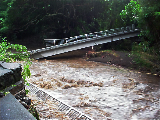 |
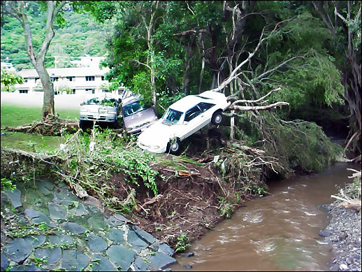
| Flood waters pushed several vehicles into the trees immediately downstream from the Woodlawn Drive Bridge. | Destroyed footbridge in the mid-valley residential area of Manoa |
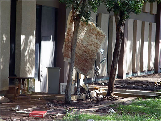 |
| Flood debris outside of Hamilton Library on the University of Hawaii at Manoa campus |
Learn More:
On the night of December 31, 1987, and through the early morning hours of January 1, 1988, heavy rainfall, with maximum 24-hour totals exceeding 22 inches, drenched east Oahu and produced devastating flash flooding in residential and agricultural areas. The highest rainfall intensities reached 4 inches in 1 hour and 15.7 inches in 6 hours in Maunawili. Most of the damage occurred as a result of flash flooding and associated debris flows in Hahaione, Niu, and Kuliouou Valleys.
In many areas, the debris flows clogged existing drainage systems, which forced flood waters out of their channels and caused severe damage to homes and roads. A rapid rise in water level within the Kawainui Marsh overtopped a protective levee and inundated a portion of the Coconut Grove community near Kailua with several feet of water.
There were no flood-related deaths or injuries, an amazing fact considering the high amount of traffic with the New Year’s celebrations in full swing. Property damage estimates totaled about $35 million (unadjusted dollars) and over 500 homes were either destroyed or damaged by flood waters.
Approximately 2800 people were evacuated and 72 were left homeless.
Learn More:
A low pressure system west of the main Hawaiian Islands helped generate an area of persistent heavy rainfall over the northeastern slopes of Kauai during the early morning hours of December 14, 1991. The Anahola Stream basin took the brunt of the storm with a maximum event rainfall total of 22 inches and peak rainfall rates of 6.7 inches in 1 hour and 11.6 inches in 2 hours recorded by NOAA/NWS rain gages.
A U.S. Geological Survey stream gage measured a record peak flow of 21,000 cubic feet per second (cfs) within a stream channel capable of handling only 4,000 cfs. The last time a flood of this magnitude occurred in Anahola was January 25, 1956, which involved a peak flow of 19,600 cfs. Significant damage also occurred at several locations along Kapaa Stream south of Anahola, and significant inundation occurred in low-lying areas of Kapaa town.
The overflow of Anahola Stream killed three people and destroyed six homes. Another individual died from flood waters in the Moloaa area north of Anahola. The damage estimate totaled $7 million (unadjusted dollars). Just over half of the total was due to the loss of public property and infrastructure. Civil Defense officials documented 180 homes destroyed or damaged by the flooding.
The November 2000 flash flood event on the Island of Hawaii, the Big Island, produced the largest single-day rainfall total ever recorded on the island and the second largest 24-hour total in the state's history. This record-breaking event came about from the ideal combination several factors needed for heavy rainfall production: Extremely moist low level air provided by the remnant of a tropical cyclone, cool and divergent air aloft to support tall thunderstorm development, and mountainous terrain to trigger and anchor thunderstorm cores.
Heavy rainfall initiated over the Hilo area during the night of November 1 then shifted into the Puna and Kau Districts on the morning of November 2. Peak rainfall intensities were 4.56 inches in 1 hour at Hilo Airport, 22.25 inches in 6 hours at Kapapala Ranch, and 37.02 inches in 24-hours, also at Kapapala Ranch. Rainfall at these intensities quickly overwhelmed existing stream channels and carved out new channels where none previously existed.
Although the press reported several water rescues, there were no serious injuries or deaths from the flash flood event. Officials reported the total damage estimate to be approximately $70 million (unadjusted dollars), mostly to roads, bridges, and other infrastructure. Several of the bridges destroyed in the flood were along the Mamalahoa Highway, the only direct route between the city of Hilo and the town of Pahala. The alternate route, around the west side of the island, adds a considerable amount of travel time and distance to the journey. The American Red Cross reported nearly 300 homes were destroyed or damaged and the Federal Emergency Management Agency reported over 2,000 people registered for disaster assistance.
 |
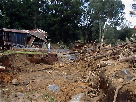 |
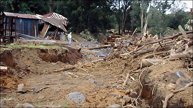
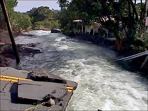
| Komohana Ave., a major thoroughfare in the city of Hilo, was severed by massive flooding at the Alenaio Stream Bridge. | Severe runoff carved out a new channel through Kapapala Ranch near the town of Pahala. A rain gage at this ranch recorded the peak storm rainfall of more than 37 inches in 24-hours and more than 22 inches in a 6-hour period. |
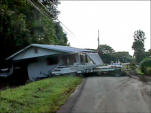 |
| Flood waters from Waiakea Stream in upper Hilo swept this home off its foundation and placed it in the middle of a public road. |
Learn More:
|
||||||

