On this page you learn what types of flooding are typical in North Dakota and how do you protect yourself, your family and your home. You will also find out more about significant North Dakota floods. Finally, you'll find links to NWS offices that provide forecast and safety information for North Dakota as well as links to our partners who play a significant role in keeping you safe.
The largest flood to affect the Minot area in well over 100 years saw roughly 25 percent of the community go under water and a near total isolation of the northern half of the. Burlington, Sawyer, and Logan are smaller communities along the Souris River that also suffered substantial damage. Widespread agricultural losses were also observed as crop and hay lands were inundated from mid-April through early July.
Learn More:
Clearly the largest flood along the Missouri River since the inception of the Pick/Sloan Program that built the 6 mainstem reservoirs. The greatest effects in North Dakota were felt in the capitol, Bismarck, with as many as 4,000 people displaced from their homes due to the high water. Mandan, located on the west side of the river from Bismarck was also substantially affected by the Missouri River flooding.
Learn More:
This event was probably the most wide spread flooding during a single spring since statehood. The 2009 flooding along the Red River of the North saw significant national news coverage as Fargo braced for a record breaking flood. Fargo was narrowly spared what befell Grand Forks in 1997, however many other ND communities weren’t so fortunate. Valley City on the Sheyenne River, Jamestown on the James River, Linton on Beaver Creek, Beulah and Hazen on the Knife River, Mandan on the Heart River all suffered when water reached record, or near record flood levels. Rural losses were also high; roughly 80,000 head of livestock were lost due to high water. Several small dams were nearly lost due to erosion of the earthen dam from flood waters. An ice jam on the Missouri River near Bismarck/Mandan saw the state bring in an explosives team to detonate charges on the river.
Learn More:
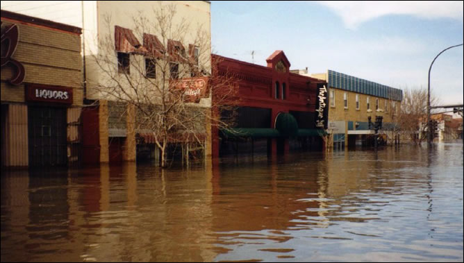
Caught largely unprepared for a high water event originating in Canada, the 1969 flood was the flood of memories prior to the 2011 event and continues to affect the area. Flood control features were built into the design of two new water supply dams in Canada and added to an existing U.S. Fish and Wildlife dam in North Dakota in response to the flood of 1969. Concurrently, major efforts were undertaken to improve channel capacity through Minot to prevent damage similar to that seen from this event.
|
||||||

