Overview
The region was located between an exceptionally warm air mass over the Southeastern States and an unseasonably cool air mass located over the Northern Plains States. At the surface, this was delineated by a weak quasi-stationary boundary that roughly extended from the lee of the Rockies into the Southern Plains across the Mid-Mississippi Valley into the Northeastern states. Being on the western edge of the surface high pressure, the region was continually being fed by the warm and moist air mass from the Gulf of Mexico.
The upper level pattern was dominated by a ridge over the Southeastern States and eastern Gulf of Mexico while a longwave trough was centered along the West Coast. Every 2-3 days, a storm system would be ejected from the West Coast trough only to replaced by another storm system digging southward from Alaska. As these systems ejected from the trough, they would cause a surface low to form in the lee of the Rockies that would then move up the front towards the Great Lakes into the Northeastern States. This produced several rounds of severe weather as well as heavy rainfall.
Downloadable KMZ File of all Tracks
 |
 |
|
| All Tornado Tracks from 20-22 May 2019 |
Tornadoes:
|
|
||||||||||
|
||||||||||
|
Tornado - Weir KS
|
||||||||||||||||
|
Tornado - Pittsburg KS
|
||||||||||||||||
|
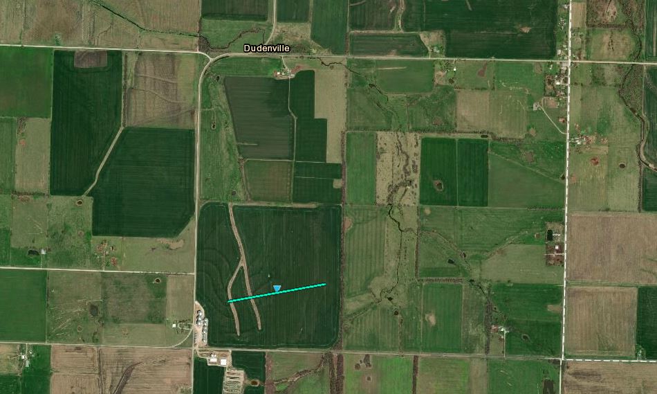
Tornado - Dudenville MO
|
||||||||||||||||
|
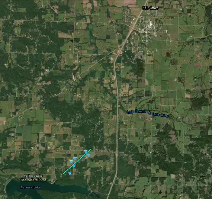
Tornado - Fair Grove MO
|
||||||||||||||||
|
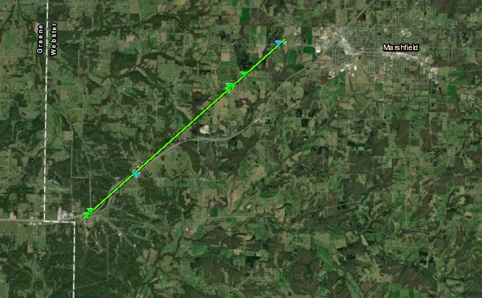
Tornado - Marshfield MO
|
||||||||||||||||
|
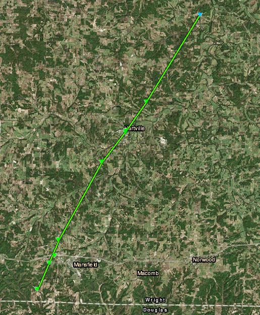
Tornado - Mansfield/Hartville MO
|
||||||||||||||||
|
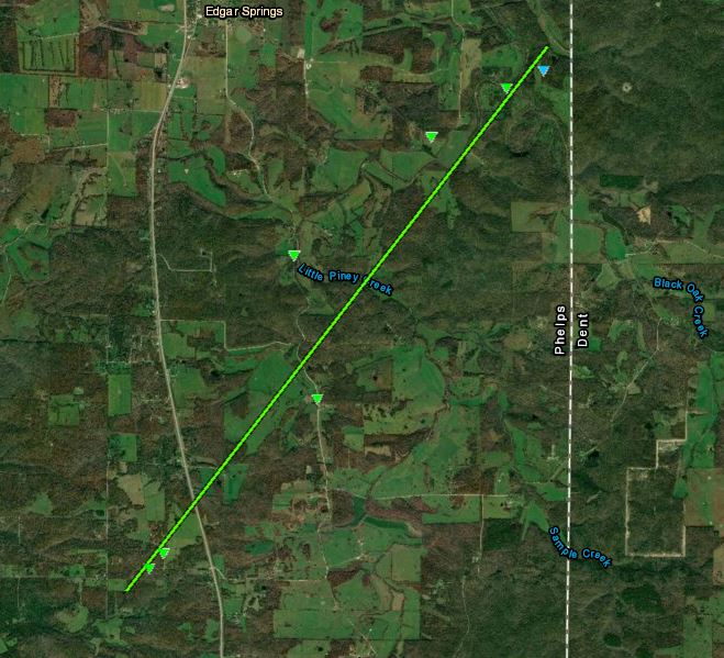
Tornado - Edgar Springs South
|
||||||||||||||||
|
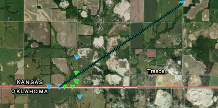
Tornado - Treece, KS
|
||||||||||||||||
|
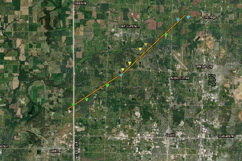
Tornado - Carl Junction, MO
|
||||||||||||||||
|
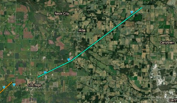
Tornado - Oronogo MO
|
||||||||||||||||
|
Tornado - Golden City, MO
|
||||||||||||||||
|
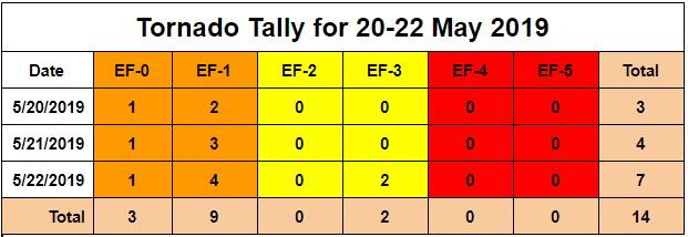
Tornado - Tiff City, MO
Track Map 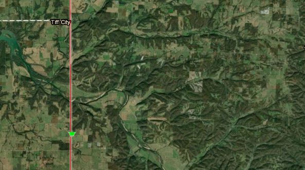 
Downloadable KMZ File |
|||||||||||||||||
|
|||||||||||||||||
|
Tornado - Laquey South
|
||||||||||||||||
|
|
The Enhanced Fujita (EF) Scale classifies tornadoes into the following categories:
| EF0 Weak 65-85 mph |
EF1 Moderate 86-110 mph |
EF2 Significant 111-135 mph |
EF3 Severe 136-165 mph |
EF4 Extreme 166-200 mph |
EF5 Catastrophic 200+ mph |
 |
|||||
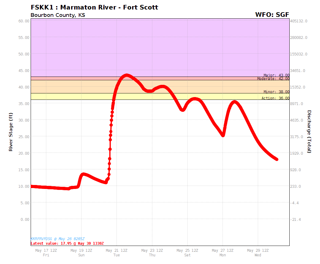
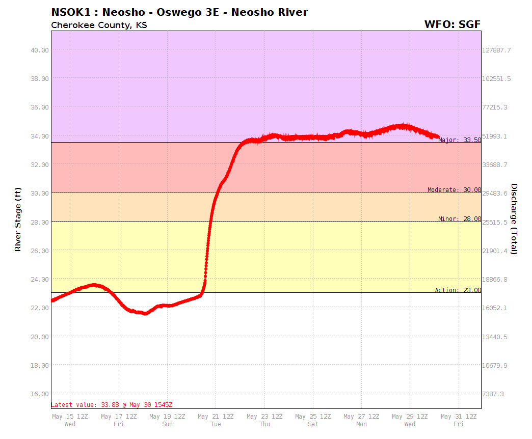
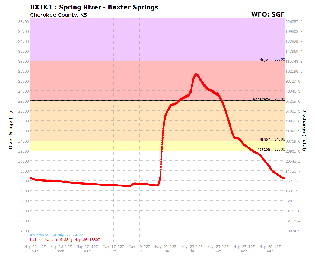
Flooding
Moderate to major river flooding resulted from the heavy rainfall associated with this storm system. Graphs showing river levels at several locations across southeast Kansas and western Missouri are included below.
Hydrographs
 |
 |
 |
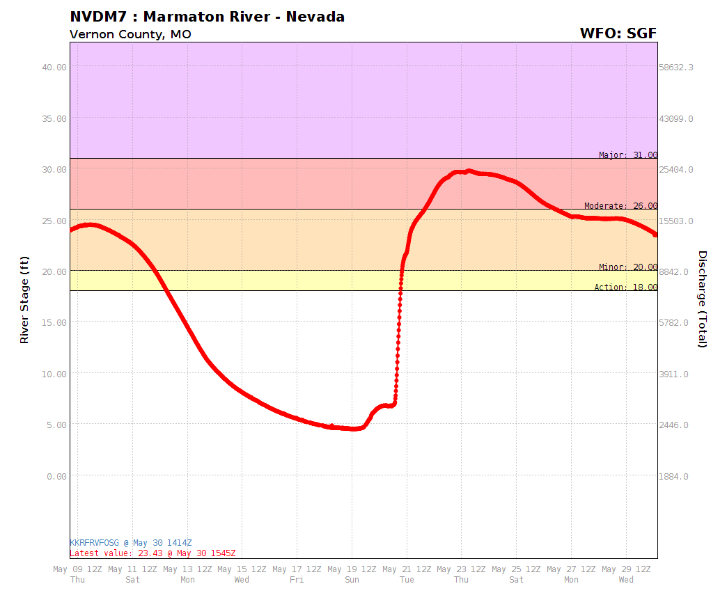 |
| Marmaton River at Fort Scott, KS | Neosho River east of Oswego, KS | Spring River at Baxter Springs, KS | Marmaton River near Nevada, MO |
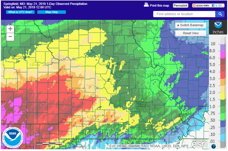
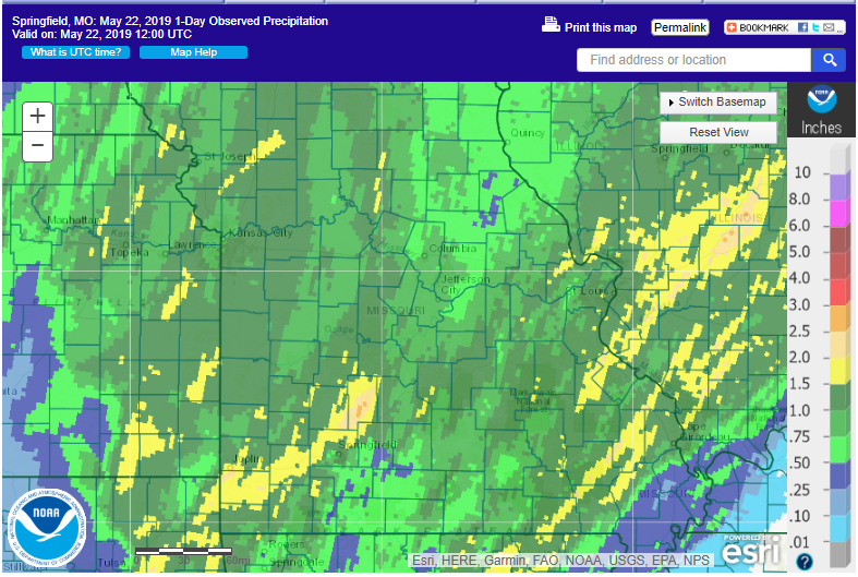
Radar/Photos
 |
 |
 |
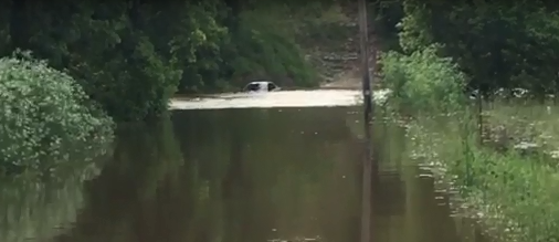 |
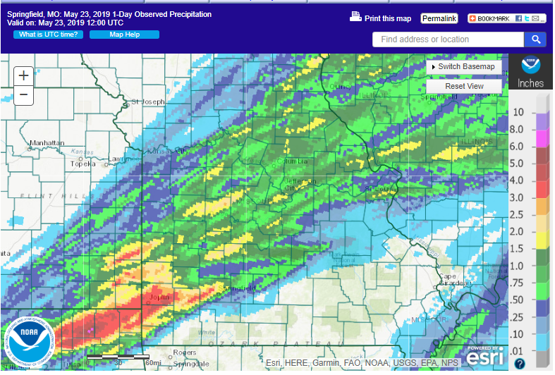
| 24-Hour Rainfall Ending 7 AM 5/21/19 | 24-Hour Rainfall Ending 7 AM 5/22/19 | 24-Hour Rainfall Ending 7 AM 5/23/19 | Flooding at Wilson's Creek and Old Limey Road southwest of Springfield |
Radar
Radar Loops
 |
 |
 |
|
| May 20 through early May 21 | May 21 | May 22 |
Storm Reports
PRELIMINARY LOCAL STORM REPORT...SUMMARY
NATIONAL WEATHER SERVICE SPRINGFIELD MO
742 PM CDT TUE MAY 28 2019
.TIME... ...EVENT... ...CITY LOCATION... ...LAT.LON
.DATE... ....MAG.... ..COUNTY LOCATION..ST.. ...SOURCE.
..REMARKS..
0142 PM HAIL BAXTER SPRINGS 37.02N 94.73W
05/20/2019 E0.70 INCH CHEROKEE KS EMERGENCY MNGR
DIME SIZE HAIL REPORTED IN BAXTER SPRINGS.
0156 PM HAIL NEOSHO 36.87N 94.37W
05/20/2019 E0.70 INCH NEWTON MO LAW ENFORCEMENT
DIME SIZED HAIL IN NEOSHO.
0211 PM HAIL 2 SE GRANBY 36.90N 94.23W
05/20/2019 E1.00 INCH NEWTON MO PUBLIC
QUARTER SIZE HAIL REPORTED 2SE OF GRANBY
MISSOURI. PUBLIC REPORT RELAYED VIA MEDIA.
0215 PM TSTM WND DMG 4 NNW PIONEER 36.89N 94.09W
05/20/2019 NEWTON MO 911 CALL CENTER
DELAYED REPORT OF TREE DOWN ON JOLLY MILL
DRIVE.
0410 PM TSTM WND DMG 1 SSE ROSELAND 37.27N 94.84W
05/20/2019 CHEROKEE KS EMERGENCY MNGR
TREES DOWN. WINDS ESTIMATED AT 70 MPH.
0410 PM TSTM WND DMG WEST MINERAL 37.29N 94.92W
05/20/2019 CHEROKEE KS EMERGENCY MNGR
TREES DOWN. WINDS ESTIMATED AT 70 MPH.
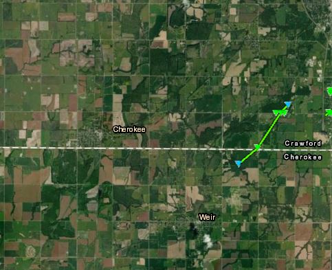
0414 PM TORNADO 2 NE WEIR 37.33N 94.75W
05/20/2019 CHEROKEE KS NWS STORM SURVEY
STARTING POINT FOR EF-1 WEIR TORNADO FROM
MAY 20TH. NUMEROUS TREE AND OUTBUILDING
DAMAGE.
0419 PM TORNADO 2 SSE CHICOPEE 37.36N 94.73W
05/20/2019 CRAWFORD KS NWS STORM SURVEY
END POINT OF WEIR EF-1 TORNADO. NUMEROUS
TREES AND OUTBUILINGS DAMAGED.
0420 PM TORNADO 3 N CARONA 37.33N 94.87W
05/20/2019 CHEROKEE KS EMERGENCY MNGR
SPOTTER SAW TORNADO. TIME BASED ON RADAR.
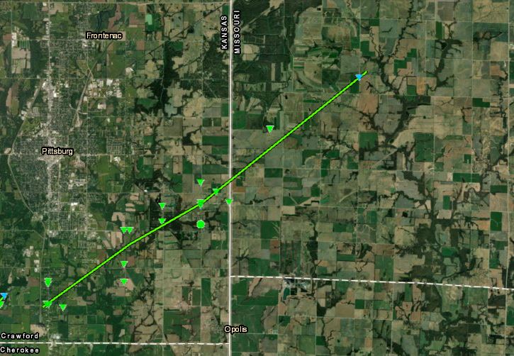
0423 PM TORNADO 3 SE CHICOPEE 37.35N 94.71W
05/20/2019 CRAWFORD KS NWS STORM SURVEY
STARTING POINT FOR PITTSBURG, KS EF-1
TORNADO. NUMEROUS TREES SNAPPED. NUMEROUS
HOMES WITH ROOF LOSS. OUTBUILINGS DESTROYED.
0434 PM TORNADO 3 SE MINDENMINES 37.44N 94.55W
05/20/2019 BARTON MO NWS STORM SURVEY
END POINT FOR PITTSBURG, KS EF-1 TORNADO.
NUMEROUS TREES SNAPPED. NUMEROUS HOMES WITH
ROOF LOSS. OUTBUILDINGS DESTROYED.
0436 PM TORNADO 5 S MINDENMINES 37.41N 94.57W
05/20/2019 BARTON MO EMERGENCY MNGR
TORNADO WENT THROUGH AREA CAUSING HOUSE AND
BUILDING DAMAGE ALONG WITH POWER LINES DOWN.
0500 PM TSTM WND DMG 4 SW MILFORD 37.54N 94.20W
05/20/2019 BARTON MO NWS STORM SURVEY
STRAIGHT LINE WIND DAMAGE TO TREES NEAR A
CHURCH AND BETWEEN STATE HIGHWAYS A AND F.
0543 PM FLASH FLOOD JOPLIN 37.08N 94.51W
05/20/2019 JASPER MO FIRE DEPT/RESCUE
STREET FLOODING OCCURRING INSIDE JOPLIN,
STALLED VEHICLE AT 17TH/MINA.
0551 PM FLASH FLOOD CARTHAGE 37.18N 94.31W
05/20/2019 JASPER MO TRAINED SPOTTER
A REPORT OF STREET FLOODING IN CARTHAGE DUE
TO HEAVY RAINFALL.
0557 PM HEAVY RAIN JOPLIN 37.08N 94.51W
05/20/2019 M1.23 INCH JASPER MO EMERGENCY MNGR
1.23 INCHES OF RAIN SO FAR.
0615 PM HEAVY RAIN 1 NW JOPLIN 37.10N 94.53W
05/20/2019 M2.15 INCH JASPER MO PUBLIC
2.15 INCHES OF RAIN SO FAR AND CLIMBING.
0618 PM FLASH FLOOD 2 NNW CARTHAGE 37.20N 94.33W
05/20/2019 JASPER MO LAW ENFORCEMENT
REPORT OF WATER OVER THE ROAD D HIGHWAY 1/2
MILE WEST OF CIVIL WAR ROAD AND WATER OVER
THE ROAD JUST SOUTH OF D/CIVIL WAR.
0640 PM TSTM WND DMG 2 E GREENFIELD 37.42N 93.81W
05/20/2019 DADE MO PUBLIC
TOP OF TREE BROKEN OFF. VIA SOCIAL MEDIA.
0650 PM TORNADO 1 SW DUDENVILLE 37.30N 94.11W
05/20/2019 JASPER MO TRAINED SPOTTER
VIDEO SHOWING TORNADO SOUTH OF GOLDEN CITY
NEAR HWY 37 AND BASELINE. NO REPORT OF
DAMAGE. VIA SOCIAL MEDIA.
0701 PM FLOOD 2 N ORONOGO 37.21N 94.47W
05/20/2019 JASPER MO LAW ENFORCEMENT
DEPUTIES ARE ADVISING OF MORE AREAS WITH
SEVERAL INCHES OF WATER OVER THE ROADWAY. SO
FAR IT SEEMS TO BE FOCUSED IN THE CENTRAL
AREA OF THE COUNTY NORTH OF ORONOGO.
0721 PM FLASH FLOOD 1 NW JOPLIN 37.09N 94.53W
05/20/2019 JASPER MO PUBLIC
CAR UNDER WATER NEAR MC DONALDS.
0730 PM TSTM WND DMG 3 E PLEASANT HOPE 37.46N 93.21W
05/20/2019 POLK MO PUBLIC
LARGE TREES UPROOTED. VIA SOCIAL MEDIA.
0730 PM TSTM WND DMG 3 WSW MARCH 37.51N 93.14W
05/20/2019 DALLAS MO PUBLIC
BARN LIFTED UP SLIGHTLY. TIN OFF OF THE MILK
BARN ROOF, TORE TREES OUT AND TOOK OUT A
SMALL POLE BARN. POSSIBLE TORNADO. VIA
SOCIAL MEDIA.
0745 PM TSTM WND DMG 1 E WALNUT 37.60N 95.06W
05/20/2019 CRAWFORD KS PUBLIC
DELAYED REPORT. TREE UPROOTED IN WALNUT VIA
SOCIAL MEDIA.
0749 PM TSTM WND DMG BOLIVAR 37.61N 93.41W
05/20/2019 POLK MO NWS STORM SURVEY
STORM SURVEY FOUND DAMAGE FROM STRAIGHT LINE
WINDS. TREES UPROOTED AND CONSTRUCTION
TRAILER OVERTURNED.
0758 PM TSTM WND DMG 1 SSW BOLIVAR 37.62N 93.41W
05/20/2019 POLK MO PUBLIC
CORRECTS PREVIOUS TSTM WND DMG REPORT TO ADD
MORE DAMAGE FROM BOLIVAR. LARGE DIAMETER
TREE BROKEN. VIA SOCIAL MEDIA. THEN THE TREE
IN THE BACK IS PARTIALLY UPROOTED AND
BROKEN. AND THERE ARE A FEW STICKS IMPALED
THE GROUND. NEXT DOOR NEIGHBOR SAID HER ROOF
IS DAMAGED.
0810 PM FLASH FLOOD 1 N ORONOGO 37.21N 94.47W
05/20/2019 JASPER MO PUBLIC
CORRECTS PREVIOUS FLASH FLOOD REPORT FROM 1
N ORONOGO. FLOODING AT KAFIR AND O
INTERSECTION NEAR ORONOGO, MO. VIA SOCIAL
MEDIAL.
0838 PM FLASH FLOOD PITTSBURG 37.41N 94.70W
05/20/2019 CRAWFORD KS CO-OP OBSERVER
REPORTS OF NUMEROUS ROADS CLOSED DUE TO
HEAVY RAIN.
0845 PM TSTM WND DMG NEVADA 37.84N 94.35W
05/20/2019 VERNON MO PUBLIC
TREE LIMBS DOWN. DIME SIZED HAIL.
0847 PM TSTM WND GST 2 SW HORTON 37.96N 94.39W
05/20/2019 M61 MPH VERNON MO PUBLIC
61 MPH GUSTS.
0910 PM HEAVY RAIN 1 NW JOPLIN 37.10N 94.53W
05/20/2019 M3.46 INCH JASPER MO PUBLIC
3.46 INCHES OF RAIN AND CLIMBING.
0915 PM TSTM WND GST 2 NNW IRON GATES 37.09N 94.56W
05/20/2019 E60 MPH JASPER MO FIRE DEPT/RESCUE
DELAYED REPORT. ESTIMATING 60-70 MPH WINDS
HAVE COME THROUGH WEST SIDE OF JOPLIN. ALSO
REPORTS OF QUARTER SIZE HAIL IN JOPLIN.
0930 PM TSTM WND DMG COLLINS 37.89N 93.62W
05/20/2019 ST. CLAIR MO EMERGENCY MNGR
SHOP BLEW OVER, SHED MOVED 6 TO 8 FT,
NUMEROUS TREES TOPS SNAPPED OFF.
0930 PM HEAVY RAIN 1 NW JOPLIN 37.10N 94.53W
05/20/2019 M4.17 INCH JASPER MO PUBLIC
4.17 INCHES AND CLIMBING.
0950 PM TSTM WND DMG WHEATLAND 37.94N 93.40W
05/20/2019 HICKORY MO NWS STORM SURVEY
STRUCTURAL DAMAGE OCCURRED ON SOUTH SIDE OF
TOWN ALONG WITH TREES AND POWER LINES DOWN.
WINDS ESTIMATED AT 90 MPH.
0955 PM FLASH FLOOD CARTHAGE 37.18N 94.31W
05/20/2019 JASPER MO PUBLIC
MANY STREETS IN CARTHAGE FLOODED.
1004 PM FLASH FLOOD 2 SW NEOSHO 36.85N 94.39W
05/20/2019 NEWTON MO EMERGENCY MNGR
REPORT OF MANY LOCAL STREETS IN NEOSHO
CLOSED DUE TO FLOODING AND A VEHICLE STALLED
IN WATER ON SPRING STREET.
1010 PM TSTM WND DMG CROSS TIMBERS 38.02N 93.23W
05/20/2019 HICKORY MO AMATEUR RADIO
NUMEROUS TREES DOWN. RELAYED BY ARES AREA
COORDINATOR.
1010 PM TSTM WND DMG FRISTOE 38.11N 93.28W
05/20/2019 BENTON MO BROADCAST MEDIA
DAMAGE TO A BARN AND ROOF DAMAGE TO A HOME.
REPORT RELAYED BY LOCAL MEDIA FROM PUBLIC.
1013 PM TSTM WND GST 4 NNW HALLTOWN 37.25N 93.65W
05/20/2019 M61 MPH LAWRENCE MO TRAINED SPOTTER
61 MPH WIND GUSTS.
1019 PM HAIL ASH GROVE 37.32N 93.58W
05/20/2019 M0.70 INCH GREENE MO AMATEUR RADIO
DIME SIZE HAIL.
1022 PM TSTM WND DMG BOIS D'ARC 37.26N 93.51W
05/20/2019 GREENE MO EMERGENCY MNGR
REPORT OF TREES DOWN IN BOIS DARC AREA -
TREES OF 10-16 DIAMETER AND SIDING BLOWN OFF
HOUSE.
1026 PM TSTM WND GST 5 SSE WILLARD 37.24N 93.39W
05/20/2019 M56 MPH GREENE MO ASOS
SGF ASOS REPORTED 56 MPH GUST.
1041 PM TSTM WND GST 1 W FAIR GROVE 37.39N 93.18W
05/20/2019 E65 MPH GREENE MO LAW ENFORCEMENT
REPORT OF 65 TO 70 MPH WINDS IN FAIR GROVE.
1043 PM TSTM WND DMG 1 ENE REPUBLIC 37.13N 93.46W
05/20/2019 GREENE MO EMERGENCY MNGR
BROOKLINE FIRE REPORTS THE RAPID ROBERTS AT
HWY 60 AND HAMILTON HAS SIGN DAMAGE.
1053 PM FLASH FLOOD 3 E BOIS D'ARC 37.25N 93.46W
05/20/2019 GREENE MO EMERGENCY MNGR
REPORT OF FLOODING OVER FARM ROAD 89, NORTH
OF STATE HIGHWAY 266 WITH AN ESTIMATED 6
INCHES OVER ROADWAY.
1055 PM FLASH FLOOD 3 NW JOPLIN 37.11N 94.54W
05/20/2019 JASPER MO FIRE DEPT/RESCUE
CORRECTS PREVIOUS FLASH FLOOD REPORT FROM 3
NW JOPLIN. THREE CARS SWEPT OFF ROAD
SCHIFFERDECKER AVE JUST SOUTH OF ZORA AVE.
1100 PM TSTM WND DMG 3 WSW MARCH 37.50N 93.14W
05/20/2019 DALLAS MO FIRE DEPT/RESCUE
CORRECTS PREVIOUS TSTM WND DMG REPORT FROM 3
WSW MARCH. ROOF BLOWN OFF A MILK BARN IN
THAT AREA.
1102 PM FLASH FLOOD 1 S POLK 37.71N 93.30W
05/20/2019 POLK MO AMATEUR RADIO
REPORT OF A POSSIBLE WATER RESCUE AT HIGHWAY
D AND HIGHWAY C, NEAR POLK.
1115 PM FLASH FLOOD 2 N SPRINGFIELD 37.23N 93.28W
05/20/2019 GREENE MO EMERGENCY MNGR
REPORT OF ONE AND HALF FOOT OF WATER OVER
THE NEAR THE INTERSECTION OF DIVISION AND
ROGERS.
1120 PM HEAVY RAIN REPUBLIC 37.12N 93.48W
05/20/2019 M2.52 INCH GREENE MO EMERGENCY MNGR
2.52 SO FAR IN DOWNTOWN REPUBLIC, SINCE THIS
SYSTEM STARTED IN ABOUT AN HOUR AGO OR SO.
1127 PM TSTM WND DMG 3 E GROVESPRING 37.40N 92.56W
05/20/2019 WRIGHT MO PUBLIC
18 INCH TREES DOWN.
1128 PM FLASH FLOOD 1 WSW ANDERSON 36.65N 94.45W
05/20/2019 MCDONALD MO EMERGENCY MNGR
CORRECTS PREVIOUS FLASH FLOOD REPORT FROM 1
WSW ANDERSON. HIGHWAY F WEST OF ANDERSON IS
CLOSED DUE TO HIGH WATER AND HIGHWAY 59 BY
76 HAS WATER OVER ROADWAY.
1130 PM TSTM WND DMG FALCON 37.60N 92.38W
05/20/2019 LACLEDE MO PUBLIC
NUMEROUS TREES DOWN. BRANCHES TWISTED. SOUTH
SIDE OF HOUSE MOVED OFF FOUNDATION. TREES
DOWN IN AREA. DELAYED REPORT. POSSIBLE TOR.
1137 PM FLASH FLOOD FAIR GROVE 37.38N 93.15W
05/20/2019 GREENE MO EMERGENCY MNGR
REPORT OF DEBRIS IN ROADWAY WITH HIGH WATER
UP TO 10 INCHES OVER THE ROADWAY AT MAIN AND
SADDLECLUB IN FAIR GROVE.
1138 PM TSTM WND DMG MONTREAL 37.97N 92.59W
05/20/2019 CAMDEN MO LAW ENFORCEMENT
REPORT OF A ROOF IN THE ROADWAY AT S HWY 7
AND HWY E IN MONTREAL.
1138 PM FLASH FLOOD 3 SW AIRPORT DRIVE 37.11N 94.54W
05/20/2019 JASPER MO LAW ENFORCEMENT
WATER RESCUE UNDERWAY AT W ZORA STREET AND
NORTH SCHIFFERDECKER AVENUE, 2 VEHICLES
SUBMERGED, BELIEVE 3 OCCUPANTS IN THE WATER,
CURRENTLY HAVE 2 RESCUE BOATS IN THE WATER.
1141 PM FLASH FLOOD 3 E MONETT 36.91N 93.87W
05/20/2019 BARRY MO PUBLIC
FLASH FLOODING OCCURING AROUND THE MONETT
AREA PER SOCIAL MEDIA REPORTS.
1143 PM FLASH FLOOD 2 NNE FAIR GROVE 37.41N 93.14W
05/20/2019 GREENE MO EMERGENCY MNGR
FAIR GROVE REPORTING 1 FOOT OF WATER OVER
ROADWAY AT 213 SOUTH OF FR 2; 1 FOOT OF
WATER OVER ROADWAY ON CABIN CREEK BETWEEN AA
AND FR 2.
1148 PM HEAVY RAIN 4 ENE POLK 37.76N 93.24W
05/20/2019 M3.45 INCH POLK MO AMATEUR RADIO
3.45 INCHES OF RAIN NOW IN NE POLK NEAR
RIMBY 5.5 MILES WEST OF LOUISBURG.
1153 PM TSTM WND DMG SAINT ROBERT 37.83N 92.17W
05/20/2019 PULASKI MO PUBLIC
DELAYED REPORT. MINOR SIDING AND GUTTER
DAMAGE TO APARTMENT. REPORT VIA SOCIAL
MEDIA.
1215 AM HAIL 8 S POWELL 36.50N 94.17W
05/21/2019 E1.00 INCH MCDONALD MO PUBLIC
DELAYED REPORT. HAIL LARGE ENOUGH TO BREAK
ROOF VENT AT RESIDENCE ALONG THE
MISSOURI/ARKANSAS STATE LINE.
0100 AM FLASH FLOOD 1 N NORTHVIEW 37.30N 92.99W
05/21/2019 WEBSTER MO NWS EMPLOYEE
AT LEAST A FOOT OF WATER FLOWING OVER
GREENWOOD ROAD AT THE POMME DE TERRE RIVER
HEADWATERS . ROAD RIGHT NEXT TO IT COLOGNA
ROAD HAS AROUND 6 INCHES FLOWING OVER IT.
0130 AM FLASH FLOOD 2 WNW SUCCESS 37.45N 92.13W
05/21/2019 TEXAS MO DEPT OF HIGHWAYS
DELAYED REPORT. STATE HIGHWAY M IS CLOSED
WEST OF HIGHWAY 17. TIME ESTIMATED.
0230 AM FLASH FLOOD 8 SSE MOUNTAIN GROVE 37.04N 92.19W
05/21/2019 DOUGLAS MO DEPT OF HIGHWAYS
DELAYED REPORT. STATE HIGHWAY EE IS CLOSED
DUE TO FLOODING. TIME ESTIMATED.
0600 AM HEAVY RAIN 2 W ANDERSON 36.65N 94.48W
05/21/2019 M4.29 INCH MCDONALD MO CO-OP OBSERVER
24HR RAINFALL. DELAYED REPORT.
0620 AM HEAVY RAIN 1 WNW CEDARVILLE 37.58N 94.01W
05/21/2019 M5.10 INCH DADE MO CO-OP OBSERVER
24 HOUR RAINFALL ACCUMULATION.
0642 AM HEAVY RAIN 1 NW JOPLIN 37.10N 94.53W
05/21/2019 M4.64 INCH JASPER MO EMERGENCY MNGR
EVENT TOTAL PRECIPITATION THROUGH 7AM.
0646 AM HEAVY RAIN 1 NW VERONA 36.98N 93.81W
05/21/2019 M3.61 INCH LAWRENCE MO PUBLIC
24 HOUR RAINFALL ACCUMULATION.
0710 AM HEAVY RAIN 1 S PITTSBURG 37.40N 94.71W
05/21/2019 M4.18 INCH CRAWFORD KS CO-OP OBSERVER
24 HOUR RAINFALL ACCUMULATION.
0724 AM HEAVY RAIN FORT SCOTT 37.84N 94.71W
05/21/2019 M4.40 INCH BOURBON KS EMERGENCY MNGR
STORM TOTAL RAINFALL ACCUMULATION SO FAR.
0727 AM HEAVY RAIN FRONTENAC 37.46N 94.69W
05/21/2019 M3.94 INCH CRAWFORD KS FIRE DEPT/RESCUE
STORM TOTAL RAINFALL ACCUMULATION.
0730 AM HEAVY RAIN MORRISVILLE 37.48N 93.43W
05/21/2019 M2.90 INCH POLK MO CO-OP OBSERVER
24 HOUR RAINFALL ACCUMULATION.
0812 AM FLOOD 2 N NEOSHO 36.90N 94.37W
05/21/2019 NEWTON MO EMERGENCY MNGR
SHOAL CREEK OVER THE ROADWAY AT LIME KILN
DRIVE.
0812 AM FLOOD SHOAL CREEK ESTATE 37.02N 94.50W
05/21/2019 NEWTON MO EMERGENCY MNGR
SHOAL CREEK OVER THE ROADWAY AT RIVER ROAD
IN JOPLIN.
0859 AM TSTM WND DMG 3 SW NEOSHO 36.84N 94.41W
05/21/2019 NEWTON MO PUBLIC
TREE DOWN VIA SOCIAL MEDIA. TIME ESTIMATED
VIA RADAR.
0908 AM FLOOD 1 W FRONTENAC 37.46N 94.71W
05/21/2019 CRAWFORD KS FIRE DEPT/RESCUE
WEST MCKAY ST AT COW CREEK IN FRONTENAC
CLOSED DUE TO FLOODING.
1035 AM HEAVY RAIN LAMAR 37.50N 94.28W
05/21/2019 M5.30 INCH BARTON MO PUBLIC
YESTERDAYS STORMS DELIVERED 5.30 INCHES OF
RAIN IN LAMAR. WE JUST HAD ANOTHER ROUND OF
VERY HEAVY RAIN THIS MORNING. BACK YARD IS
TOO SLOPPY TO CHECK THE RAIN GAUGE, BUT I
WOULD IMAGINE WE RECEIVED AT LEAST ANOTHER
1.5 INCHES OF RAIN.
1103 AM FLOOD 4 E BRONAUGH 37.70N 94.39W
05/21/2019 VERNON MO LAW ENFORCEMENT
TROOPER REPORTS WATER OVER ROADWAY ON ROUTE
N NEAR ROUTE BB, NORTHWEST OF SHELDON.
1105 AM FLOOD 4 ENE RED OAK 37.24N 93.95W
05/21/2019 LAWRENCE MO LAW ENFORCEMENT
WATER REPORTED OVER ROADWAY ON MISSOURI 97,
APPROXIMATELY 4 MILES NORTH OF MISSOURI 96.
1249 PM TSTM WND DMG 4 NW BATTLEFIELD 37.16N 93.42W
05/21/2019 GREENE MO FIRE DEPT/RESCUE
12 INCH DIAMETER TREE DOWN AND 10 INCH
DIAMETER TREE UPROOTED ON ORR ST.
1257 PM TSTM WND DMG 1 ENE SPRINGFIELD 37.20N 93.27W
05/21/2019 GREENE MO PUBLIC
TOP OF TREE SNAPPED OFF IN ROUNTREE
NEIGHBORHOOD OF SPRINGFIELD. PICTURE VIA
SOCIAL MEDIA.
0106 PM TSTM WND DMG 3 WSW BASSVILLE 37.33N 93.19W
05/21/2019 GREENE MO PUBLIC
PROPERTY AND TREE DAMAGE BY FELLOWS LAKE.
TIME BASED ON RADAR.
0106 PM TORNADO 3 WSW BASSVILLE 37.33N 93.19W
05/21/2019 GREENE MO NWS STORM SURVEY
NWS STORM SURVEY FOUND AN EF-0 WITH MAXIMUM
WINDS OF 85MPH ALONG A 1 MILE PATH JUST
NORTH OF FELLOWS LAKE. TREES UPROOTED. TREES
HAD BRANCHES SNAPPED OFF AT TOPS. BARN HAD
ROOF BLOWN OFF. OUTBUILDING BLOWN OFF
FOUNDATION. MINOR SHINGLE DAMAGE TO HOMES.
0109 PM FLOOD 3 SW SPRINGFIELD 37.16N 93.32W
05/21/2019 GREENE MO BROADCAST MEDIA
WATER ON THE ROADWAY AT BATTLEFIELD AND
KANSAS EXPRESSWAY. REPORT OF STALLED CAR DUE
TO THE HIGH WATER ON ROADWAY PER MEDIA
PARTNER.
0110 PM TSTM WND DMG FAIR GROVE 37.39N 93.15W
05/21/2019 GREENE MO PUBLIC
PICTURES OF 3 INCH DIAMETER TREE BRANCHES
BROKEN ON ORCHARD ROAD IN FAIR GROVE.
0115 PM TSTM WND DMG STRAFFORD 37.27N 93.12W
05/21/2019 GREENE MO PUBLIC
CORRECTS PREVIOUS NON-TSTM WND DMG REPORT
FROM STRAFFORD. LARGE TREE BROKEN TOWARDS
THE BASE.
0145 PM HEAVY RAIN 1 WSW BUFFALO 37.64N 93.12W
05/21/2019 E1.59 INCH DALLAS MO COCORAHS
REPORT OF 1.59 INCHES OF RAINFALL IN 2
HOURS.
0224 PM HEAVY RAIN 1 W BRANSON 36.64N 93.23W
05/21/2019 M1.50 INCH TANEY MO AMATEUR RADIO
MEASURED 1.5 RAIN IN 20 MINUTES 2 MI SOUTH
OF 76/I65 INTERSECTION IN BRANSON.
0225 PM TSTM WND DMG OZARK 37.02N 93.20W
05/21/2019 CHRISTIAN MO PUBLIC
POWER LINES DOWN AT OAK AND 3RD IN OZARK MO.
TIME BASED ON RADAR ESTIMATE.
0235 PM FLASH FLOOD 2 NE SPRINGFIELD 37.21N 93.26W
05/21/2019 GREENE MO AMATEUR RADIO
REPORT OF 6 INCHES OF WATER AT TRAFFICWAY
AND WAVERLY OVER THE STREET.
0242 PM TSTM WND DMG 1 S BASSVILLE 37.33N 93.13W
05/21/2019 GREENE MO FIRE DEPT/RESCUE
CORRECTS PREVIOUS TSTM WND DMG REPORT FROM 1
S BASSVILLE. 15 INCH TREE IN ROAD WAY ON HWY
125.
0247 PM TORNADO 1 N NORTHVIEW 37.30N 93.00W
05/21/2019 WEBSTER MO AMATEUR RADIO
CORRECTS PREVIOUS TORNADO REPORT FROM 1 N
NORTHVIEW TIME. TORNADO AT MILE MARKER 92.8
ON I44. 18 WHEELER ON ITS SIDE. DAMAGE AT
THE OLD ANIMAL PARADISE.
0247 PM TORNADO 1 N NORTHVIEW 37.30N 93.00W
05/21/2019 WEBSTER MO AMATEUR RADIO
CORRECTS PREVIOUS TORNADO REPORT FROM 1 N
NORTHVIEW TIME. TORNADO AT MILE MARKER 92.8
ON I44. 18 WHEELER ON ITS SIDE. DAMAGE AT
THE OLD ANIMAL PARADISE.
0249 PM TORNADO 1 N NORTHVIEW 37.30N 93.00W
05/21/2019 WEBSTER MO AMATEUR RADIO
TORNADO AT MILE MARKER 92.8 ON I44. 18
WHEELER ON ITS SIDE. DAMAGE AT THE OLD
ANIMAL PARADISE.
0250 PM TORNADO 3 NNE NORTHVIEW 37.32N 92.98W
05/21/2019 WEBSTER MO NWS STORM SURVEY
NWS STORM SURVEY FOUND EF 1 DAMAGE WITH MANY
TREES SNAPPED AND UPROOTED ALONG WITH ROOF
DAMAGE.
0302 PM FLASH FLOOD 3 NE BATTLEFIELD 37.16N 93.35W
05/21/2019 GREENE MO PUBLIC
FAST MOVING WATER IN A RESIDENTIAL AREA.
0312 PM TORNADO 2 NW AVA 36.97N 92.69W
05/21/2019 DOUGLAS MO PUBLIC
TORNADO ON THE GROUND NW OF AVA, MO TREE
LIMBS AND A UPROOTED TREE.
0312 PM TORNADO 2 NW AVA 36.97N 92.69W
05/21/2019 DOUGLAS MO PUBLIC
TORNADO ON THE GROUND NW OF AVA, MO TREE
LIMBS AND A UPROOTED TREE.
0314 PM FLASH FLOOD 2 W FAIR GROVE 37.39N 93.18W
05/21/2019 GREENE MO EMERGENCY MNGR
WATER OVER ROADWAYS AND BARRIERS REQUESTED
AT FR 199 TO SUNSET AND FR 199 TO 193 IN
FAIR GROVE.
0316 PM HEAVY RAIN 1 WSW BUFFALO 37.64N 93.11W
05/21/2019 M4.93 INCH DALLAS MO PUBLIC
4.93 INCHES OF RAIN FROM 7PM YESTERDAY TO
3:16 PM TODAY.
0317 PM TORNADO 2 W MANSFIELD 37.11N 92.61W
05/21/2019 WRIGHT MO NWS STORM SURVEY
STARTING POINT FOR MANSFIELD/HARTVILLE
TORNADO. PEAK WINDS 110 MPH WITH NUMEROUS
TREES SNAPPED AND UPROOTED ALONG ITS PATH
INCLUDING IN MANSFIELD AND HARTVILLE.
GROCERY STORE IN HARTVILLE HAD THE STORE
COLLAPSE.
0319 PM TORNADO 1 NE MANSFIELD 37.12N 92.57W
05/21/2019 WRIGHT MO PUBLIC
POWER LINES DOWN NORTH OF MANSFIELD, MO.
TIME BASED ON RADAR ESTIMATE.
0319 PM TORNADO 1 NE MANSFIELD 37.12N 92.57W
05/21/2019 WRIGHT MO PUBLIC
POWER LINES DOWN NORTH OF MANSFIELD, MO.
TIME BASED ON RADAR ESTIMATE.
0330 PM TORNADO HARTVILLE 37.25N 92.51W
05/21/2019 WRIGHT MO LAW ENFORCEMENT
TREES DOWN AND DAMAGE TO BUILDINGS.
0330 PM TORNADO HARTVILLE 37.25N 92.51W
05/21/2019 WRIGHT MO LAW ENFORCEMENT
TREES DOWN AND DAMAGE TO BUILDINGS.
0334 PM TSTM WND DMG 2 SSW ZANONI 36.66N 92.35W
05/21/2019 OZARK MO EMERGENCY MNGR
3 LARGE TREES DOWN OVER AA IN GAINESVILLE
NEAR COUNTRY ROAD 307.
0340 PM TORNADO 2 W MANES 37.38N 92.41W
05/21/2019 WRIGHT MO NWS STORM SURVEY
ENDING POINT FOR MANSFIELD/HARTVILLE
TORNADO. EF-1 TORNADO WITH PEAK WINDS OF 110
MPH.
0340 PM TSTM WND DMG HARTVILLE 36.59N 92.37W
05/21/2019 OZARK MO LAW ENFORCEMENT
CORRECTS PREVIOUS TSTM WND DMG REPORT
LOCATION FROM HARDENVILLE TO HARTVILLE. LOTS
OF DAMAGE IN HARTVILLE. TOWN AND COUNTRY
BUILDING FRONT OF THE STORE BLOWN DOWN.
0345 PM FLASH FLOOD 4 NW BUFFALO 37.69N 93.14W
05/21/2019 DALLAS MO DEPT OF HIGHWAYS
DELAYED REPORT. STATE HIGHWAY C IS CLOSED
DUE TO FLOODING. TIME ESTIMATED.
0355 PM TSTM WND DMG 3 W WAYNESVILLE 37.83N 92.26W
05/21/2019 PULASKI MO EMERGENCY MNGR
DELAYED REPORT. MULTIPLE REPORTS OF
POWERLINES DOWN THROUGHOUT THE COUNTY.
0404 PM TSTM WND DMG WAYNESVILLE 37.83N 92.20W
05/21/2019 PULASKI MO EMERGENCY MNGR
MULTIPLE REPORTS OF POWERLINES DOWN
THROUGHOUT THE COUNTY. TIME BASED ON RADAR.
0409 PM TSTM WND DMG 3 S SILOAM SPRINGS 36.75N 92.08W
05/21/2019 HOWELL MO AMATEUR RADIO
TWO TREES DOWN ON CC HIGHWAY 13 MILES OUT OF
WEST PLAINS, MO.
0410 PM TSTM WND DMG 4 ENE SILOAM SPRINGS 36.82N 92.01W
05/21/2019 HOWELL MO PUBLIC
HUGE TREES DOWN ON DRIVEWAY. GATES, FENCES
AND MAIL BOXES DOWN. HALF OF THE SIDE OF A
LUMBER BARN DESTROYED. DELAYED REPORT.
0415 PM TSTM WND DMG 4 N POTTERSVILLE 36.75N 92.03W
05/21/2019 HOWELL MO EMERGENCY MNGR
TREES DOWN ON POWER LINES JUST WEST OF
TIMBERLAND PALLET, 10 MILES WEST OF WEST
PLAINS MO ON 160 HIGHWAY.
0416 PM TSTM WND DMG SOUTH FORK 36.63N 91.96W
05/21/2019 HOWELL MO EMERGENCY MNGR
911 REPORTING TREE ON A STRUCTURE ON 11587
CO ROAD 6690 ACROSS FROM E HIGHWAY, WEST
PLAINS MO.
0418 PM TORNADO 3 WSW EDGAR SPRINGS 37.70N 91.91W
05/21/2019 PHELPS MO PUBLIC
PUBLIC REPORT OF TORNADO.
0418 PM TORNADO 4 E BEULAH 37.63N 91.85W
05/21/2019 PHELPS MO NWS STORM SURVEY
STORM SURVEY FOUND HUNDREDS OF TREES
UPROOTED ALONG ITS PATH NORTHEAST AND ENDED
NEAR THE PHELPS/DENT LINE.
0425 PM TORNADO 3 SW EDGAR SPRINGS 37.67N 91.89W
05/21/2019 PHELPS MO PUBLIC
TORNADO ON THE GROUND SOUTHWEST OF EDGAR
SPRINGS. DEBRIS BEING PICKED UP IN THE AIR
AT THE MOMENT. SMALL ELEPHANT TRUNK TORNADO.
0425 PM TORNADO 3 SW EDGAR SPRINGS 37.67N 91.89W
05/21/2019 PHELPS MO PUBLIC
TORNADO ON THE GROUND SOUTHWEST OF EDGAR
SPRINGS. DEBRIS BEING PICKED UP IN THE AIR
AT THE MOMENT. SMALL ELEPHANT TRUNK TORNADO.
0436 PM TSTM WND DMG 1 S LECOMA 37.76N 91.73W
05/21/2019 DENT MO PUBLIC
STORM DAMAGE FROM THIS EVENING IN NORTHWEST
DENT COUNTY ABOUT 1 MILE SOUTH OF LECOMA.
NUMEROUS TREES UPROOTED OR SHREDDED AND
WINDOWS BLOWN OUT OF NEIGHBORS HOUSE. NO
INJURIES LUCKILY. VIA SOCIAL MEDIA.
0442 PM TSTM WND GST 1 NNW VICHY 38.13N 91.77W
05/21/2019 M58 MPH MARIES MO ASOS
ASOS REPORTS GUST OF 50.0 KNOTS FROM SW. 58
MPH.
0450 PM TSTM WND DMG 4 E BANGERT 37.76N 91.45W
05/21/2019 DENT MO PUBLIC
DELAYED REPORT. TREES DOWN VIA SOCIAL MEDIA.
0455 PM FLOOD 3 ESE REPUBLIC 37.11N 93.43W
05/21/2019 GREENE MO EMERGENCY MNGR
FLOODING REPORTED AT FARM ROAD 186 AND FARM
ROAD 101 - 3.5 FEET OF WATER.
0515 PM FLOOD WAYNESVILLE 37.83N 92.20W
05/21/2019 PULASKI MO EMERGENCY MNGR
PULASKI COUNTY, WAYNESVILLE SUPERIOR ROAD AT
THE PARK CLOSED DUE TO FLOODING ON THE ROAD.
WAYNESVILLE RV PARK ALSO CLOSED DUE TO
WATER.
0529 PM FLOOD 2 ESE BOIS D'ARC 37.24N 93.47W
05/21/2019 GREENE MO EMERGENCY MNGR
REPORTED 6 TO 8 OF WATER OVER THE ROAD AT
HIGHWAY EE BETWEEN FARM ROAD 89 AND 81. LOW
WATER SIGNS ARE IN PLACE.
0600 PM FLOOD 1 N AURORA 36.98N 93.72W
05/21/2019 LAWRENCE MO PUBLIC
ROADS COVERED WITH MOVING WATER.
0700 PM HEAVY RAIN 5 SSE WILLARD 37.23N 93.40W
05/21/2019 M3.89 INCH GREENE MO ASOS
24HR TOTAL FROM 7PM YESTERDAY THROUGH 7PM
TODAY. NWS OFFICIAL OBSERVATION.
0744 PM FLOOD 5 NE GOODMAN 36.78N 94.33W
05/21/2019 NEWTON MO TRAINED SPOTTER
SEVERAL ROADS REMAIN CLOSED OR WASHED OUT
ACROSS NEWTON COUNTY.
0651 PM HAIL 1 SE SHERWIN 37.17N 94.94W
05/22/2019 E1.75 INCH CHEROKEE KS EMERGENCY MNGR
0730 PM HAIL EL DORADO SPRINGS 37.88N 94.02W
05/22/2019 E1.50 INCH CEDAR MO PUBLIC
0734 PM TORNADO 2 W TREECE 37.00N 94.87W
05/22/2019 CHEROKEE KS NWS STORM SURVEY
A NWS SURVEY CONFIRMED AN EF-0 TORNADO THAT
BEGAN IN OKLAHOMA BEFORE CROSSING THE STATE
LINE FROM OKLAHOMA INTO KANSAS AND THEN
LIFTING NEAR HIGHWAY 69 NORTH OF TREECE 2
MINUTES AFTER CROSSING OVER FROM THE
OKLAHOMA BORDER. SEVERAL TREES WERE SNAPPED
AND UPROOTED ALONG THE PATH. PEAK WINDS WERE
75 MPH, WITH A PATH LENGTH OF 3 MILES AND A
MAXIMUM PATH WIDTH OF 0.25 MILES. NO
INJURIES OR DEATHS WERE REPORTED.
0748 PM HAIL ROSCOE 37.97N 93.81W
05/22/2019 E1.50 INCH ST. CLAIR MO PUBLIC
CORRECTS TIME OF PREVIOUS HAIL REPORT FROM
ROSCOE. PING PONG BALL TO QUARTER SIZE HAIL.
VIA SOCIAL MEDIA. DELAYED REPORT.
0800 PM FLASH FLOOD 1 SSW ALBA 37.22N 94.42W
05/22/2019 JASPER MO DEPT OF HIGHWAYS
DELAYED REPORT. STATE HIGHWAYS D AND O
CLOSED DUE TO FLOODING. TIME ESTIMATED.
0805 PM TORNADO 3 NNE GALENA 37.11N 94.62W
05/22/2019 CHEROKEE KS NWS STORM SURVEY
STARTING POINT OF CARL JUNCTION TORNADO.
NUMEROUS HOMES WITH ROOF DAMAGE AND SEVERAL
WITH DAMAGE TO THE EXTERIOR WALLS...SEVERAL
POWER POLES SNAPPED OR LEANING...NUMEROUS
TREES SNAPPED. TORNADO WAS ON THE GROUND FOR
ABOUT 14 MINUTES. TORNADO WAS A EF-3 WITH
MAX WINDS OF 140MPH.
0806 PM HAIL 1 SSW NEVADA 37.83N 94.36W
05/22/2019 E1.00 INCH VERNON MO PUBLIC
VIA SOCIAL MEDIA.
0813 PM TORNADO 2 SE CARL JUNCTION 37.16N 94.54W
05/22/2019 JASPER MO TRAINED SPOTTER
SEVERAL LARGE TREES DOWN AND HOMES WITH ROOF
DAMAGE ON LAKEVIEW LANE JUST WEST OF HWY 171
AND CENTER CREEK IN CARL JUNCTION, MO TDS
ALSO IN THIS AREA.
0819 PM TORNADO 4 NE CARL JUNCTION 37.18N 94.51W
05/22/2019 JASPER MO NWS STORM SURVEY
ENDING POINT OF THE CARL JUNCTION EF-3
TORNADO. NUMEROUS HOMES WITH ROOF DAMAGE AND
SEVERAL WITH DAMAGE TO THE EXTERIOR
WALLS...SEVERAL POWER POLES SNAPPED OR
LEANING...NUMEROUS TREES SNAPPED. TORNADO
WAS ON THE GROUND FOR ABOUT 14 MINUTES.
0825 PM TSTM WND DMG 2 NNE ORONOGO 37.21N 94.45W
05/22/2019 JASPER MO PUBLIC
CORRECTS TIME OF PREVIOUS TSTM WND DMG
REPORT FROM 2 NNE ORONOGO. LARGE TREES DOWN
ACROSS ROAD. VIA SOCIAL MEDIA. DELAYED
REPORT.
0827 PM TORNADO 1 NE ORONOGO 37.20N 94.45W
05/22/2019 JASPER MO NWS STORM SURVEY
STARTING POINT OF ORONOGO EF-0 TORNADO.
NUMEROUS TREES DAMAGED OR DESTROYED FROM
LARGE BRANCHES TO SOFTWOOD TRUNKS SNAPPED.
TORNADO WAS ON THE GROUND FOR ABOUT 8
MINUTES.
0830 PM HAIL LINCOLN 38.39N 93.33W
05/22/2019 M1.00 INCH BENTON MO 911 CALL CENTER
0835 PM TORNADO 4 NE ALBA 37.26N 94.35W
05/22/2019 JASPER MO NWS STORM SURVEY
ENDING POINT OF EF-0 ORONOGO TORNADO.
NUMEROUS TREES DAMAGED OR DESTROYED FROM
LARGE BRANCHES TO SOFTWOOD TRUNKS SNAPPED.
TORNADO WAS ON THE GROUND FOR ABOUT 8
MINUTES.
0851 PM TORNADO 4 SE JASPER 37.31N 94.24W
05/22/2019 JASPER MO NWS STORM SURVEY
*** 3 FATAL, 1 INJ ***
STARTING POINT FOR GOLDEN CITY EF-3 TORNADO.
MOBILE HOMES DAMAGED AND
DESTROYED....NUMEROUS HOME WITH ROOF DAMAGE
AND SEVERAL WITH DAMAGE TO OUTSIDE WALLS. IN
ADDITION...SEVERAL POWER POLES WERE SNAPPED
AND NUMEROUS TREES HAD TRUNKS SNAPPED.
TORNADO WAS ON THE GROUND FOR 22 MINUTES.
0857 PM TORNADO 6 WNW DUDENVILLE 37.34N 94.19W
05/22/2019 JASPER MO STORM CHASER
STRUCTURE AND TREE DAMAGE OBSERVED BY STORM
CHASER.
0905 PM HAIL 5 N GOLDEN CITY 37.46N 94.10W
05/22/2019 E1.50 INCH BARTON MO STORM CHASER
0911 PM TORNADO GOLDEN CITY 37.39N 94.09W
05/22/2019 BARTON MO LAW ENFORCEMENT
MAJOR STRUCTURAL DAMAGE IN THE GOLDEN CITY
AREA.
0913 PM TORNADO 3 N GOLDEN CITY 37.43N 94.10W
05/22/2019 BARTON MO NWS STORM SURVEY
*** 3 FATAL, 1 INJ ***
ENDING POINT FOR EF-3 GOLDEN CITY TORNADO.
MOBILE HOMES DAMAGED AND
DESTROYED....NUMEROUS HOME WITH ROOF DAMAGE
AND SEVERAL WITH DAMAGE TO OUTSIDE WALLS. IN
ADDITION...SEVERAL POWER POLES WERE SNAPPED
AND NUMEROUS TREES HAD TRUNKS SNAPPED.
TORNADO WAS ON THE GROUND FOR 22 MINUTES.
0937 PM HAIL 3 NW UMBER VIEW HEIGHTS 37.66N 93.85W
05/22/2019 E1.00 INCH CEDAR MO STORM CHASER
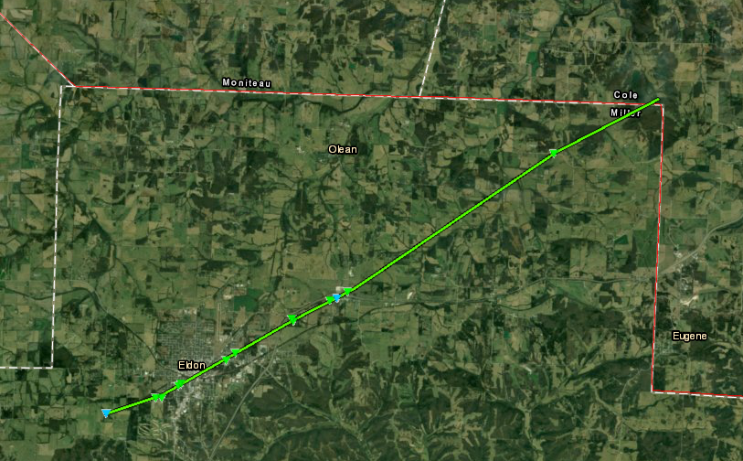
1056 PM TORNADO 2 WSW ELDON 38.33N 92.61W
05/22/2019 MILLER MO NWS STORM SURVEY
*** 1 INJ ***
STARTING POINT FOR EF-1 ELDON TORNADO.
TORNADO BEGAN SOUTHWEST OF ELDON AND WENT
THROUGH ELDON AND TO THE NORTHEAST,
EVENTUALLY CROSSING INTO COLE COUNTY.
NUMEROUS TREES UPROOTED, SEVERAL HOMES HAD
PARTIAL ROOF LOSS.
1102 PM TSTM WND DMG ELDON 38.35N 92.58W
05/22/2019 MILLER MO EMERGENCY MNGR
GETTING REPORTS OF DAMAGE IN ELDON. DETAILS
UNCERTAIN AT THIS TIME. POSSIBLE TDS.
1116 PM TORNADO 5 NE ETTERVILLE 38.42N 92.41W
05/22/2019 MILLER MO NWS STORM SURVEY
*** 1 INJ ***
POINT WHERE EF-1 ELDON TORNADO CROSSED INTO
COLE COUNTY. TORNADO BEGAN SOUTHWEST OF
ELDON AND WENT THROUGH ELDON AND TO THE
NORTHEAST, EVENTUALLY CROSSING INTO COLE
COUNTY. TREES UPROOTED, SOME HOMES HAD
PARTIAL ROOFS OFF.
0124 AM HAIL 5 WNW SLEEPER 37.78N 92.68W
05/23/2019 E1.50 INCH LACLEDE MO PUBLIC
DELAYED REPORT. SOCIAL MEDIA PICTURE.
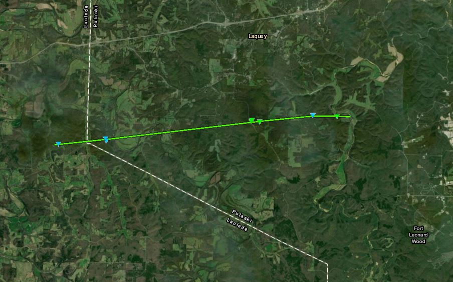
0149 AM TORNADO 5 N DRY KNOB 37.72N 92.44W
05/23/2019 LACLEDE MO NWS STORM SURVEY
STARTING POINT FOR SOUTH LAQUEY EF-1
TORNADO. NUMEROUS TREE DAMAGE AND MOBILE
HOMES OVERTURNED.
0210 AM TORNADO 4 WNW FORT LEONARD WOOD 37.73N 92.23W
05/23/2019 PULASKI MO NWS STORM SURVEY
END POINT FOR SOUTH LAQUEY TORNADO. NUMEROUS
TREE DAMAGE AND MOBILE HOMES OVERTURNED.
0318 AM TSTM WND DMG 5 NE SPRINGFIELD 37.25N 93.22W
05/23/2019 GREENE MO PUBLIC
LARGE TREE SPLIT IN TWO. TIME BASED ON RADAR
ESTIMATE. VIA SOCIAL MEDIA.
0400 AM FLASH FLOOD 1 SE FLORENCE 38.58N 92.96W
05/23/2019 MORGAN MO DEPT OF HIGHWAYS
STATE HIGHWAY BB CLOSED DUE TO FLOODING.
TIME ESTIMATED.
0450 AM TSTM WND DMG 2 WSW DIAMOND 36.99N 94.36W
05/23/2019 NEWTON MO EMERGENCY MNGR
TREE DOWN BLOCKING ROADWAY. TIME ESTIMATED
VIA RADAR.
0500 AM FLASH FLOOD 6 WNW GOODMAN 36.78N 94.50W
05/23/2019 NEWTON MO DEPT OF HIGHWAYS
DELAYED REPORT. STATE HIGHWAY AA CLOSED DUE
TO FLOODING. TIME ESTIMATED.
0529 AM FLASH FLOOD 3 S WILLARD 37.26N 93.43W
05/23/2019 GREENE MO LAW ENFORCEMENT
ROADWAY FLOODED AT 106 AND AB HWY.
0530 AM FLASH FLOOD 2 NE SPRINGFIELD 37.22N 93.26W
05/23/2019 GREENE MO LAW ENFORCEMENT
WATER ON ROADWAY ON GLENSTONE PKWY BETWEEN
DIVISION ST. AND CHESTNUT EXPY.
0537 AM FLASH FLOOD 5 WNW SPRINGFIELD 37.21N 93.38W
05/23/2019 GREENE MO EMERGENCY MNGR
WATER OVER ROADWAY AT STATE HWY EE AND
HAZELTINE RD.
0555 AM FLASH FLOOD 3 NW SPRINGFIELD 37.22N 93.32W
05/23/2019 GREENE MO PUBLIC
NUMEROUS REPORTS OF FLOODED ROADWAYS IN
NORTHERN AND WESTERN SPRINGFIELD.
0616 AM FLASH FLOOD 2 W OAKLAND PARK 37.11N 94.51W
05/23/2019 JASPER MO PUBLIC
MULTIPLE INTERSECTIONS ALONG ZORA ST. IN
JOPLIN UNDER WATER DUE TO HEAVY RAIN AND
RUNOFF.
0630 AM HEAVY RAIN 2 NE SOUTH GREENFIELD 37.40N 93.81W
05/23/2019 M2.00 INCH DADE MO CO-OP OBSERVER
24HR TOTAL.
0638 AM FLASH FLOOD 1 NNE DUENWEG 37.10N 94.41W
05/23/2019 JASPER MO EMERGENCY MNGR
MULTIPLE LOW WATER CROSSINGS ARE FLOODED OUT
IN JASPER COUNTY. ALSO HAVE BEEN SEVERAL
WATER RESCUE CALLS FOR TRAFFIC.
0648 AM FLASH FLOOD PITTSBURG 37.41N 94.70W
05/23/2019 CRAWFORD KS FIRE DEPT/RESCUE
MAJOR STREET FLOODING IN PITTSBURG. ONE
WATER RESCUE COMPLETED SO FAR.
0652 AM HEAVY RAIN 5 SSE WILLARD 37.24N 93.38W
05/23/2019 M3.70 INCH GREENE MO ASOS
CORRECTS TIME OF PREVIOUS HEAVY RAIN REPORT
FROM 5 SSE WILLARD. SGF ASOS MEASURED 6 HOUR
ACCUMULATION THROUGH 7AM.
0653 AM HEAVY RAIN 1 WNW WEBB CITY 37.15N 94.50W
05/23/2019 M3.59 INCH JASPER MO ASOS
CORRECTS TIME OF PREVIOUS HEAVY RAIN REPORT
FROM 1 WNW WEBB CITY. JLN ASOS 24 HOUR
ACCUMULATION THROUGH 7AM.
0708 AM HEAVY RAIN 5 SSE WILLARD 37.23N 93.40W
05/23/2019 M4.64 INCH GREENE MO OFFICIAL NWS OBS
CORRECTS TIME AND REPORT SOURCE OF PREVIOUS
HEAVY RAIN REPORT FROM 5 SSE WILLARD. NWS
OFFICE OBSERVED 6 HOUR ACCUMULATION THROUGH
7:08 AM.
0730 AM HEAVY RAIN COLUMBUS 37.17N 94.84W
05/23/2019 M2.50 INCH CHEROKEE KS CO-OP OBSERVER
24HR TOTAL.
0753 AM HEAVY RAIN STARK CITY 36.86N 94.19W
05/23/2019 M3.38 INCH NEWTON MO PUBLIC
3.38 INCHES OF RAIN.
0755 AM FLOOD CARTHAGE 37.18N 94.31W
05/23/2019 JASPER MO PUBLIC
SIGNIFICANT FLOODING THROUGHOUT TOWN.
0800 AM HEAVY RAIN 4 S ASH GROVE 37.26N 93.59W
05/23/2019 M3.00 INCH GREENE MO CO-OP OBSERVER
24HR PRECIP TOTAL.
0800 AM HEAVY RAIN 2 NW MCCUNE 37.37N 95.04W
05/23/2019 M3.48 INCH CRAWFORD KS COCORAHS
24HR TOTAL.
0800 AM HEAVY RAIN 3 SE BROOKLYN HEIGHTS 37.14N 94.36W
05/23/2019 M3.43 INCH JASPER MO COCORAHS
24HR TOTAL.
0800 AM HEAVY RAIN 4 NNE REPUBLIC 37.17N 93.44W
05/23/2019 M4.05 INCH GREENE MO COCORAHS
24HR TOTAL.
0800 AM HEAVY RAIN 4 NE HIATTVILLE 37.76N 94.81W
05/23/2019 M3.02 INCH BOURBON KS COCORAHS
24HR TOTAL.
0800 AM HEAVY RAIN 1 S CARTHAGE 37.16N 94.31W
05/23/2019 M3.30 INCH JASPER MO COCORAHS
24HR TOTAL.
0818 AM FLOOD 4 ESE BOIS D'ARC 37.24N 93.44W
05/23/2019 GREENE MO PUBLIC
ROAD FLOODED.
0830 AM HEAVY RAIN 2 ESE SACVILLE 37.38N 93.39W
05/23/2019 M3.34 INCH GREENE MO COCORAHS
24HR TOTAL.
0855 AM FLASH FLOOD JOPLIN 37.09N 94.51W
05/23/2019 JASPER MO PUBLIC
CORRECTS PREVIOUS FLASH FLOOD REPORT FROM
JOPLIN. RUNNING WATER RISING ON ROADS
CAUSING THEM TO BE CLOSED. VIA SOCIAL MEDIA.
0900 AM FLASH FLOOD 3 ESE BOIS D'ARC 37.24N 93.46W
05/23/2019 GREENE MO EMERGENCY MNGR
NUMEROUS ROADS IN WESTERN GREENE COUNTY
CLOSED DUE TO FLASH FLOODING.
0900 AM HEAVY RAIN 1 E IRON GATES 37.07N 94.54W
05/23/2019 E4.40 INCH JASPER MO PUBLIC
24HR TOTAL. VIA SOCIAL MEDIA.
0915 AM FLASH FLOOD 1 W OAKLAND PARK 37.11N 94.50W
05/23/2019 JASPER MO LAW ENFORCEMENT
METS AMBULANCE UNITS OUT WITH JOPLIN FIRE IN
THE AREA OF N HIGHLAND AVENUE AND KENSINGTON
STREET - WATER RESCUE OF OCCUPANTS OF
MULTIPLE HOMES.
0920 AM HEAVY RAIN CARTHAGE 37.18N 94.31W
05/23/2019 E5.00 INCH JASPER MO PUBLIC
5.00 INCHES OF RAIN OVERNIGHT ON EAST SIDE
OF TOWN. VIA SOCIAL MEDIA.
0945 AM FLASH FLOOD 1 W PHILLIPSBURG 37.55N 92.80W
05/23/2019 LACLEDE MO LAW ENFORCEMENT
WATER OVER BOTH EAST AND WEST BOUND LANES OF
I-44 AROUND THE 118 MM WITH TEMPORARY
CLOSURE.
1000 AM FLASH FLOOD 5 NNE TWIN BRIDGES 37.61N 92.56W
05/23/2019 LACLEDE MO DEPT OF HIGHWAYS
STATE HIGHWAY B IS CLOSED DUE TO FLOODING.
1200 PM HEAVY RAIN 3 ENE POLK 37.75N 93.25W
05/23/2019 M7.05 INCH POLK MO AMATEUR RADIO
RAINFALL TOTAL SINCE MIDNIGHT MONDAY
MORNING.
Rain Reports
3-Day Totals Ending at 7 AM 5/23/19
| Location | Rain Total |
| Joplin | 11.26 |
| Baxter Springs | 10.61 |
| Carl Junction 3.4 WS | 10.13 |
| Lamar 0.3 SSE FSA-01 | 9.65 |
| Joplin | 8.86 |
| Springfield WFO | 8.69 |
| McCune 1.6 NW | 8.45 |
| Brookline 2.3 NNW FS | 8.2 |
| Fort Scott 8.2 SW | 7.88 |
| Carthage 1.5 S FSA-0 | 7.73 |
| Shoal Creek Estates | 7.68 |
| Springfield | 7.61 |
| Pittsburg 0.7 WSW | 7.59 |
| Pittsburg | 7.57 |
| Phillipsburg 5.0 NW | 7.55 |
| Diamond 2W | 7.33 |
| WALNUT GROVE 5.2 SE | 7.05 |
| Lamar Water Station | 7.04 |
| Mt. Vernon Ozark Aqu | 6.99 |
| Farlington 0.8 NNE | 6.79 |
| Cherokee 0.3 N | 6.74 |
| Girard | 6.66 |
| Moundville 2.3 S | 6.63 |
| Walnut | 6.62 |
| Eldorado Springs | 6.47 |
| Neosho 3.9 WNW FSA-1 | 6.45 |
| Fort Scott 3.7 ENE | 6.45 |
| Oswego 3E - Neosho R | 6.34 |
| Flemington 4E | 6.09 |
| Tiff City | 5.78 |
| Stockton 0.2 NW FSA- | 5.68 |
| Waco | 5.63 |
| Osceola 0.3 SW FSA-1 | 5.56 |
| Republic 0.8 ESE | 5.52 |
| Stockton 2.5 NNE | 5.43 |
| Buffalo 2N | 5.42 |
| Lockwood | 5.39 |
| Lincoln 0.4 NNE FSA- | 5.31 |
| Wah Kon Tah RAWS | 5.14 |
| Bolivar 1.0 ENE FSA- | 5.12 |
| Springfield 5.3 SSW | 5.07 |
| Fair Play 1.3 E | 5.05 |
| Asbury Water Station | 5.04 |
| Buffalo 1.0 SW FSA-0 | 4.98 |
| Fulton | 4.77 |
| Noel 3.8 NNE | 4.65 |
| Hermitage 0.5 ESE FS | 4.6 |
| Neosho Ozark Aquifer | 4.57 |
| Greenfield 0.8 SSW F | 4.51 |
| Cole Camp 3.5 WNW | 4.5 |
| Cole Camp | 4.5 |
| Morrisville - Little | 4.49 |
| Springfield 5.5 SSW | 4.45 |
| Marshfield 1.4 W FSA | 4.45 |
| Wheatland 2.7 S | 4.4 |
| Springfield East - P | 4.34 |
| Valley Water Mill Wa | 4.29 |
| Lebanon 1.3 E FSA-10 | 4.15 |
| Versailles(inactive) | 4.14 |
| Marshfield | 4.09 |
| Ash Grove | 4.03 |
| Lost Valley Hatchery | 4.02 |
| Hartville (inactive) | 3.93 |
| Hartville 0.5 SSE FS | 3.92 |
| Clever 4.0 ENE | 3.82 |
| Mansfield | 3.75 |
| Millwood | 3.72 |
| Springfield SE - Jam | 3.64 |
| Bingham Elementary | 3.58 |
| Warsaw 0.4 WNW | 3.44 |
| Springfield Livestoc | 3.41 |
| Purdy 4.8 SSW | 3.38 |
| Hazelgreen | 3.37 |
| Washburn | 3.34 |
| Norwood Well | 3.34 |
| Marshfield 0.9 SE | 3.33 |
| Mansfield 3.7 SSE | 3.28 |
| Licking | 3.25 |
| Golden City 6S | 3.25 |
| Fair Grove 4.7 SSW | 3.2 |
| Morrisville 2SW | 3.17 |
| CASSVILLE RAWS | 3.12 |
| Anderson 3.2 NNW FSA | 3.06 |
| Linn Creek 9.4 SE FS | 3.06 |
| Springfield Landfill | 3.06 |
| Houston 1NE | 3.04 |
| Dadeville-Sac River | 3.02 |
| Fort Scott | 3 |
| Cassville | 2.96 |
| Richland 3.6 NNW FSA | 2.93 |
| AVA 6.0 NW | 2.9 |
| Osage Beach | 2.86 |
| Powell - Big Sugar C | 2.84 |
| Brumley 5.6 SW | 2.79 |
| Alley Spring | 2.79 |
| Lebanon Water Statio | 2.7 |
| Northwest Water Trea | 2.69 |
| Sinkin RAWS | 2.68 |
| Ft Leonard Wood | 2.67 |
| Round Spring | 2.66 |
| Eminence 0.1 SSE FSA | 2.64 |
| Rutledge-Wilson Farm | 2.62 |
| Pineville 7SW - Litt | 2.62 |
| Lynchburg-Roubidoux | 2.61 |
| Montauk State Park | 2.61 |
| Mountain View 6.6 NE | 2.59 |
| Lamar 7N | 2.59 |
| Carthage | 2.57 |
| Nevada | 2.53 |
| West Plains | 2.52 |
| Greenfield 2SE | 2.5 |
| Columbus | 2.5 |
| Iberia 5.6 NW FSA-13 | 2.48 |
| Eminence 1N | 2.45 |
| Montauk SP - Licking | 2.45 |
| Rolla 0.9 SE FSA-161 | 2.43 |
| Kimberling City | 2.43 |
| Iberia | 2.43 |
| Ava 0.8 NNW FSA-067 | 2.41 |
| Salem 14.9 E | 2.39 |
| Winona 2.8 SW | 2.39 |
| West Plains Water St | 2.39 |
| Winona | 2.39 |
| Vienna 4.3 NNW FSA-1 | 2.36 |
| West Plains 2.2 NNW | 2.35 |
| Willard Community Ce | 2.35 |
| West Plains | 2.34 |
| Rolla 5E | 2.34 |
| Edgar Springs - Big | 2.34 |
| Carr Creek | 2.33 |
| Rolla/Vichy | 2.26 |
| Newburg-Little Piney | 2.22 |
| Linn 0.8 SE | 2.2 |
| Rolla | 2.18 |
| Galena | 2.16 |
| Versailles 0.2 SE FS | 2.15 |
| Turner Station | 2.15 |
| Lincoln 0.4 NNE - FS | 2.11 |
| Gravois Mills 8.4 S | 2.1 |
| Galena | 2.1 |
| Rolla Water Station | 2.08 |
| Eldon | 2.08 |
| Branson - Bull Creek | 2.07 |
| Strafford High Schoo | 2.03 |
| Anderson 3W | 2.03 |
 |
Media use of NWS Web News Stories is encouraged! Please acknowledge the NWS as the source of any news information accessed from this site. |
|


 Weather Story
 Weather Map
 Local Radar
 Follow us on YouTube