
Tsunami impacts continue for portions of the Pacific basin. Wildfire smoke causes unhealthy air in Midwest to Great Lakes. Heat dome spans Mississippi Valley to Mid-Atlantic with excessive heat warnings and advisories. Critical fire weather in Great Basin to Pacific Northwest (dry thunderstorms). Cold front spawns severe storms/heavy rain in Central U.S. today, shifts to East Coast Thursday. Read More >
Figure 1 shows the geographic regions across West Central Texas, which are referenced in this summary.
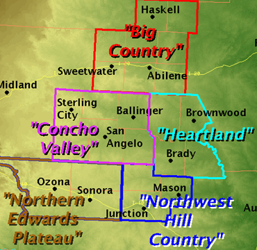
Figure 1: Geographic Regions of West-Central Texas.
Precipitation was below normal for the month, while temperatures averaged slightly above normal. Table 1 summarizes January 2016 temperature, precipitation, and departure from normal for Abilene and San Angelo.
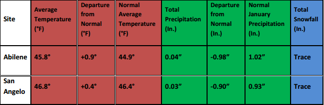
Table 1: January Climate Data for Abilene and San Angelo.
Additional temperature and precipitation data for Abilene and San Angelo is summarized in Table 2.
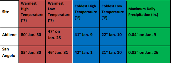
Table 2: Additional January Climate Data for Abilene and San Angelo.
The monthly precipitation was well-below normal across most of west-central Texas (Figure 2).
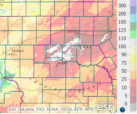
Figure 2: Percentage of Normal Precipitation for January.
Across areas where the percentage of normal precipitation was less than 25 percent (red shading), the monthly amounts were less than one quarter of an inch (not shown). Only in extreme northwestern Crockett County was the monthly precipitation above normal.
January was marked by a progressive upper level flow pattern, with several dry cold frontal passages. Dry airmasses occupied the region in January. The combination of dry air and generally clear skies allowed for large temperature swings between the daytime highs and nighttime lows (more than 35 degrees) on several days at some locations, during the middle and late parts of the month.
Two precipitation events occurred during the month. On the 2nd, some Light rain occurred across southern parts of west-central Texas. Some locations southeast of a Sonora to Mason line received one quarter to one half inch of rainfall.
On the 26th, precipitation occurred with the arrival of an upper level trough. The precipitation was mostly a cold rain. With much colder temperatures, however, pockets of wet snow occurred in southern parts of west-central Texas, mainly in Crockett and Sutton Counties. Less than 1 inch of snow accumulation was reported in Sonora. A few locations in Crockett County received over one-half inch of rainfall (Figure 3).
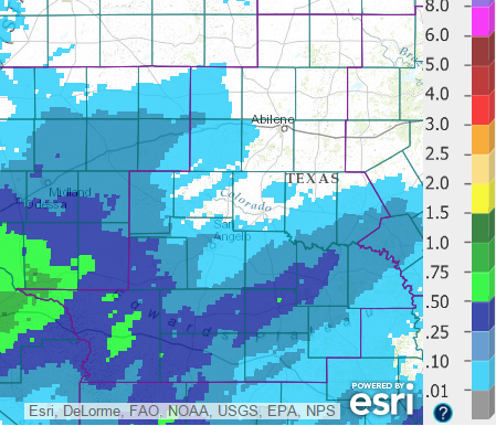
Figure 3: Total Precipitation for the 24-hour period ending at 7 AM, January 27.
Elevated to near critical fire weather conditions occurred on the last few days of the month. Well-above normal afternoon temperatures were combined with increased and gusty winds, and rather dry air on the 29th through 31st. Relative humidity values dropped below 20 percent during the afternoon hours. With sunny skies, highs were in the middle 70s across much of west-central Texas on the 29th, and in the upper 70s to middle 80s on the 30th. A record high temperature (85 degrees) was set at San Angelo on the 30th. A weak cold front moved south into the Big Country on the 31st, and highs were in the upper 70s to lower 80s south of this front.
With the elevated to critical fire weather conditions, a few wildfires occurred in west-central Texas. A wildfire in Callahan County burned approximately 642 acres southwest of Eula. With this fire, a total of 7 homes and 6 outbuildings were lost, and one person was injured from smoke inhalation. Other small wildfires occurred in Nolan and Coleman Counties.


 Virtual Tour
 Weather Briefing
 Satellite Loops
 Past Weather Reports
 Past Rainfall Maps
 Drought Information
 River & Lake Levels
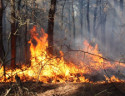 Fire Weather
 Aviation Weather
 Additional Resources
 Social Media