
Severe thunderstorms, heavy rainfall, and flooding are possible from the northern Rockies into the Upper Midwest. A derecho is likely across portions of the northern Plains, with several gusts expected to exceed 75 mph. Extreme heat is expected to intensify across much of the Southeast and Tennessee Valley, continuing through much of this week. Read More >
September temperatures averaged above normal, and precipitation was well-above normal, for most of west-central Texas. Table 1 summarizes September 2016 temperatures, precipitation, and departures from normal for Abilene and San Angelo.
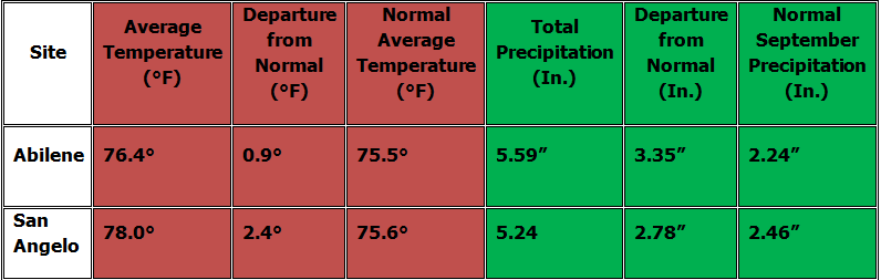
Table 1: September Climate Data for Abilene and San Angelo.
This was the 14th wettest September for Abilene (records date back to 1886), and the 16th wettest September for San Angelo (records date back to 1907).
Additional temperature and precipitation data for Abilene and San Angelo is summarized in Table 2.
.PNG)
Table 2: Additional September Climate Data for Abilene and San Angelo.
Maps of total precipitation for August (Figure 1) and percent of normal precipitation for the month (Figure 2) are shown below.
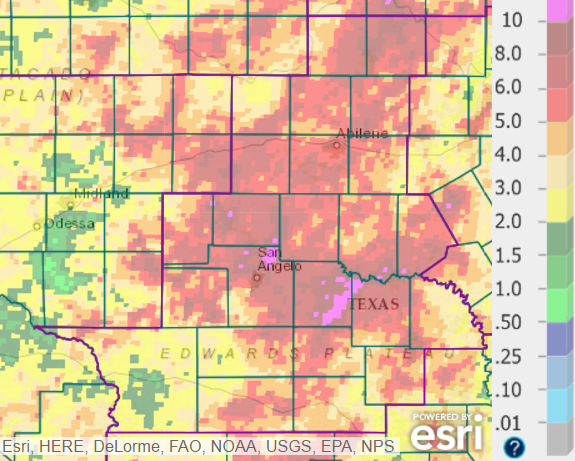
Figure 1: Total Precipitation for September.
September rainfall was more than 4 inches across much of west-central Texas (denoted by orange and red shading). A few locations in the Concho Valley north and east of San Angelo received in excess of 10 inches. The lowest rainfall for September occurred in parts of Crockett County (shown in green shading).
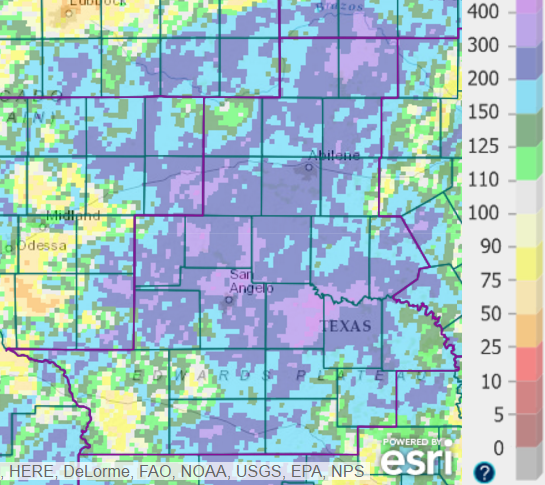
Figure 2: Percentage of Normal Precipitation for September.
September rainfall was well-above normal (denoted by blue and purple shading) across most of west-central Texas. The monthly rainfall was slightly below normal (shown in yellow shading) in much of Crockett County, in parts of western Schleicher and northwestern Sutton Counties, in extreme eastern Callahan County, and in eastern and northeastern Kimble Counties.
During the first week of September, temperatures were fairly close to normal, and little or no precipitation occurred during that time. Hot and fairly humid conditions occurred on the 8th and 9th, as an upper level high pressure system briefly shifted to the west over the area.
Showers and thunderstorms occurred along and behind a cold front, which moved south across west-central Texas on the 10th. Rainfall was locally heavy, and scattered locations received 1-3 inches. A few locations, mainly in Irion and Throckmorton Counties, received more than 3 inches of rain. Temperatures were cooler on the 10th, and highs were in the mid to upper 70s at some locations.
The pattern was unsettled on September 13-18. Scattered showers and thunderstorms occurred on the 13th and 14th. This was the result of weak upper level disturbances interacting with a fairly moist airmass, and the arrival of a weak cold front on the 14th. A few severe storms occurred in the northern half of west-central Texas on the evening of the 16th. The Abilene Regional Airport recorded a 44 mph wind gust on the 16th. Gusty winds accompanied some of the storms on the 17th ant 18th. San Anglo Regional Airport recorded peak wind gusts of 43 mph on the 17th, and 41 mph on the 18th.
Hot daytime temperatures occurred on September 19-23, with an upper level high pressure system over Texas.
A heavy rain event on September 24-25 resulted in flash flooding in the San Angelo and Sweetwater areas.
With considerable cloud cover and rain, temperatures were much cooler on the 25th. In the wake of a cold frontal passage, daytime temperatures were unusually cool on the 26th, with lingering cloud cover and north-northeast winds. Highs on the 26th ranged from the mid 60s to lower 70s.
The month ended with cool early morning low temperatures on the 30th, which were in the upper 40s to lower 50s across most of west-central Texas.


 Virtual Tour
 Weather Briefing
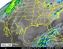 Satellite Loops
 Past Weather Reports
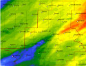 Past Rainfall Maps
 Drought Information
 River & Lake Levels
 Fire Weather
 Aviation Weather
 Additional Resources
 Social Media