
Tropical Depression Two is expected to gradually strengthen and could bring tropical storm conditions to the Florida Panhandle beginning late Monday. Areas of flash flooding will be possible through Thursday along the eastern and central Gulf Coast. Severe thunderstorms will develop and move along a cold front crossing the Upper Midwest Monday, and through the Ohio Valley/Mid-Atlantic on Tuesday. Read More >
A severe weather event occurred across West Central Texas on March 28. With the approach of a strong upper level storm system from New Mexico and the approach of a dryline from West Texas, scattered strong to severe thunderstorms affected the Big Country area during the afternoon and evening hours. With very unstable air in place along with favorable vertical wind shear, a number of these storms were severe, including 2 tornadic supercells. One of the storms tracked north-northeast across parts of Taylor, Jones and Haskell Counties. The other storm moved north-northeast across Fisher County. Brief tornado touchdowns were reported with both of these storms. These tornadoes were in open fields in rural areas, and only minor damage occurred. Several storms produced hail of quarter to golfball size.
Late in the evening, a line of thunderstorms developed rapidly across West Texas, as a Pacific cold front moved east and overtook a retreating dryline. The line of strong to severe storms moved quickly east across nearly all of West Central Texas between 8 PM and Midnight. Wind gusts of 60-70 mph were measured or reported at several locations across the area.
In all, a total of 26 severe weather reports were received for this event.
Figure 1 shows an animated loop of radar imagery, with scattered thunderstorms moving north-northeast across the Big Country area.

Figure 1: Animated Loop of Radar Imagery on March 28 (between 338 PM and 738 PM).
Figure 2 shows an animated loop of radar imagery, of the line of thunderstorms moving quickly east across West Central Texas.
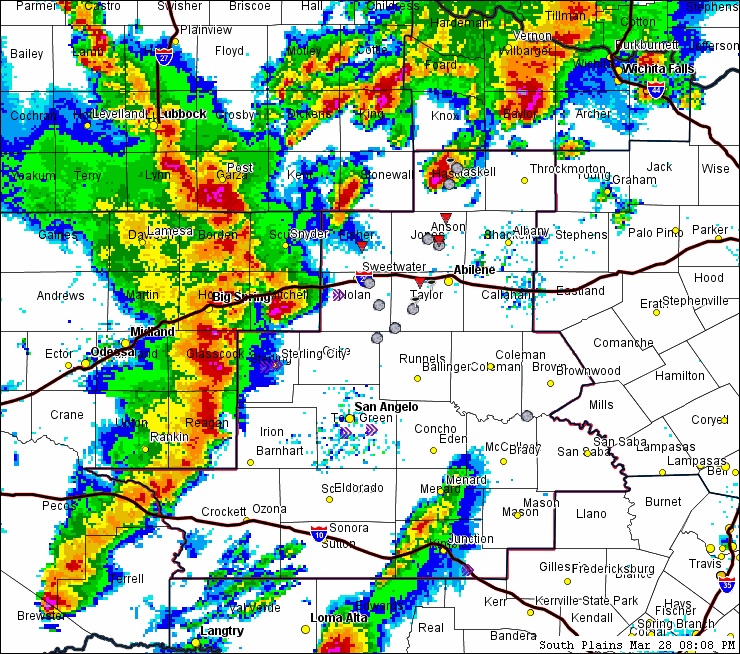
Figure 2: Animated Loop of Radar Imagery (808 PM, March 28 to 1208 AM, March 29).

