
Tropical Depression Two is expected to gradually strengthen and could bring tropical storm conditions to the Florida Panhandle beginning late Monday. Areas of flash flooding will be possible through Thursday along the eastern and central Gulf Coast. Severe thunderstorms will develop and move along a cold front crossing the Upper Midwest Monday, and through the Ohio Valley/Mid-Atlantic on Tuesday. Read More >
San Angelo, TX
Weather Forecast Office
A severe weather event occurred across parts of west-central Texas (northern Heartland and southern Big Country areas) on the late afternoon through late evening hours of May 18. With the approach of an upper level disturbance and dryline into a very unstable airmass, along with favorable vertical shear, scattered strong to severe storms affected the northern Heartland and southern Big Country areas.
Most of the severe weather occurred with a supercell storm which tracked slowly east across northeastern Runnels, northern Coleman and northern Brown Counties. This storm produced baseball size hail near Crews (Runnels County), and tennis ball size hail 7 miles north of Coleman (Coleman County). Strong winds caused damage to roof shingles, carports and canopies of residences at Lake Coleman. In northern Brown County, this storm produced a tornado in the vicinity of Cross Cut and May.
Another severe storm tracked north across western Callahan and southwestern Shackelford Counties, and golfball size hail was reported with this storm.
In all, a total of 19 severe weather reports were received for this event.
Figure 1 shows an animated loop of radar imagery, with the severe thunderstorms which affected the aforementioned areas.
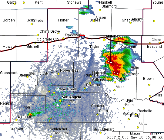
Figure 1: Animated Loop of Radar Imagery on May 18 (between 500 PM and 900 PM).
US Dept of Commerce
National Oceanic and Atmospheric Administration
National Weather Service
San Angelo, TX
7654 Knickerbocker Road
San Angelo, TX 76904
325-944-0526
Comments? Questions? Please Contact Us.

