San Juan, PR
Weather Forecast Office
NOTICE TO ALL USERS: The graphical surf zone forecast is experimental and may not be available at all times. For additional information, please contact the webmaster. For additional hazard outlook information, visit the Experimental Graphical Hazardous Weather Outlook (GHWO).
AVISO A TODOS LOS USUARIOS: El pronóstico gráfico de la zona de rompiente es experimental y puede no estar disponible en todo momento. Para información adicional, comuníquese con el webmaster. Para información adicional sobre peligros en perspectiva, visite el Experimental Graphical Hazardous Weather Outlook (GHWO).
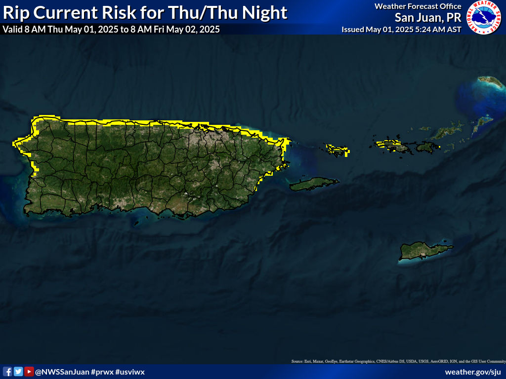
Before heading to the beach, check the forecast and understand the level of rip current risk. Dangerous conditions can develop even when the weather looks good.
| Risk Level | Description | More Info |
|---|---|---|
| Low | The risk is low, but dangerous rip currents can still occur near inlets, groins, jetties, reefs, and piers. |
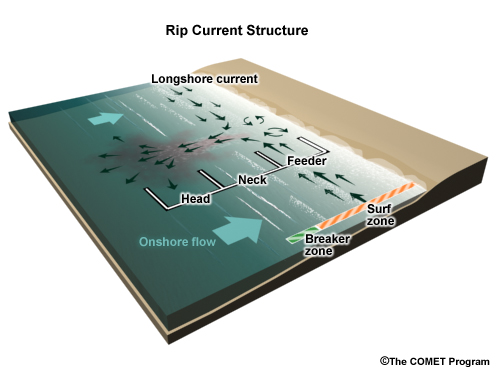
The map shows the forecast rip current risk level. Rip currents are strong channels of water moving away from shore. Swim parallel to escape and follow beach warnings. |
| Moderate | Life-threatening rip currents are possible in the surf zone. | |
| High | Life-threatening rip currents are likely in the surf zone. | |
| Safety Videos | Surf Zone Forecast | |
Antes de ir a la playa, revise el pronóstico y conozca el nivel de riesgo de corrientes marinas.
| Nivel de Riesgo | Descripción | Más Información |
|---|---|---|
| Bajo | El riesgo es bajo, pero pueden ocurrir corrientes peligrosas cerca de estructuras costeras. |
El mapa muestra el nivel de riesgo. Las corrientes marinas se alejan de la costa. Nade paralelo a la orilla para escapar. |
| Moderado | Corrientes peligrosas son posibles en la zona de rompiente. | |
| Alto | Corrientes peligrosas son probables. | |
| Videos de Seguridad | Pronóstico | |

US Dept of Commerce
National Oceanic and Atmospheric Administration
National Weather Service
San Juan, PR
4000 Carretera 190
Carolina, PR 00979
787-253-4586
Comments? Questions? Please Contact Us.


 7-Day Graphical Hazardous Weather Outlook
 Tropical Analysis
 Tropical Weather
 Regional Satellite
 Puerto Rico and US Virgin Islands
 Local Radar