|
Synoptic Overview
|
|
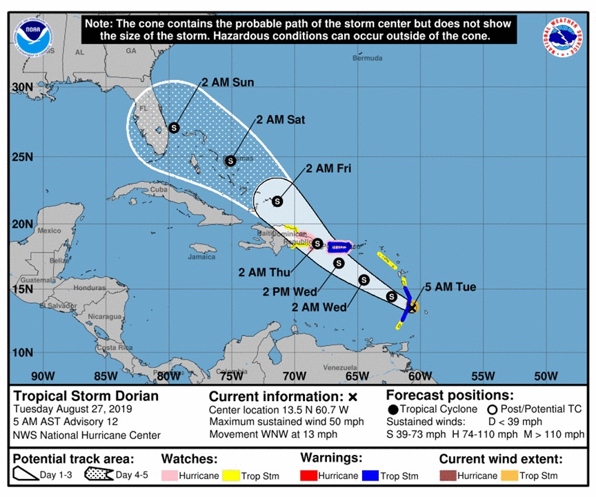
Tropical Depression Five formed about 800 miles east-southeast of Barbados on August 24th, 2019 at 11 am AST. At 5 PM AST, Tropical Depression Five was upgraded to Tropical Storm Dorian with maximum sustained winds of 40 mph, heading west-northwest as it was steered by a subtropical high pressure to the north. There were competing environmental factors present favoring, as well as inhibiting strengthening. Favorable factors for strengthening included warm sea surface temperatures greater than 28ºC and light vertical wind shear less than 10 knots. In contrast, the inhibiting factor was very dry air above 6 km with relative humidity less than 50%, measured by a dropsonde from the hurricane hunter on the evening of August 25th. Dry air at 550 to 350 MB was being ingested into the storm from the south, limiting convection and subsequent development. During the next couple of days, Dorian continued on a west-northwestward track, affecting Barbados on the evening of August 26th and St. Lucia during the morning of August 27th. Despite Dorian being in an environment of low vertical wind shear and high sea surface temperatures, the storm had difficulty strengthening as a result of mid-level dry air entraining over the storm at times. Dorian continued on a west-northwest track towards Puerto Rico and the U.S. Virgin Islands.
Figure 1: Loop of the NHC forecast from August 27, 2019 at 5 AM AST to August 28, 2019 at 5 PM AST.
The official track of the National Hurricane Center during the morning of August 27th had the storm tracking near the southwest portion of Puerto Rico and into the Mona Passage. However, the situation changed during the day as the center of Dorian reformed a degree latitude further north. As a result, the trajectory changed significantly, with the center of the storm moving between the northern USVI and Culebra on August 28th. As Dorian moved over these islands, hurricane-force winds were reported over portions of Saint Thomas, leading to Dorian upgrade to a Category 1 Hurricane at the 2 PM AST. Tropical storm to hurricane-force winds along with heavy rainfall continued to impact the islands of Saint Thomas and Saint John through the afternoon hours. The island of Culebra reported sustained tropical-storm-force winds. On August 29th, the trailing trough of Dorian affected the area with the southern and eastern half of Puerto Rico observing rounds of heavy rainfall along with numerous thunderstorms. Between 2 and 6 inches of rain were observed, which resulted in flash flooding, particularly across eastern Puerto Rico. Heavy showers were also observed across Saint Thomas and Saint John of the USVI, however, of lesser magnitude. |
Presione aquí para retornar a la página principal del Servicio Nacional de Meteorología
|
Satellite & Radar Imagery
|
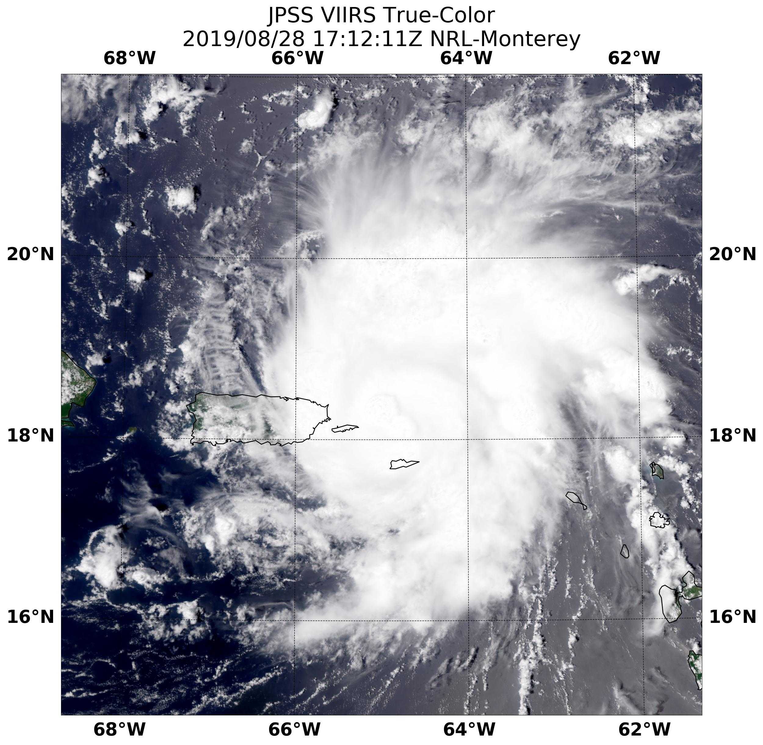
Figure 2: JPSS VIIRS True Color image of Hurricane Dorian near St. Croix at 1712 UTC August 28, 2019. Image courtesy of NRL-Monterrey.
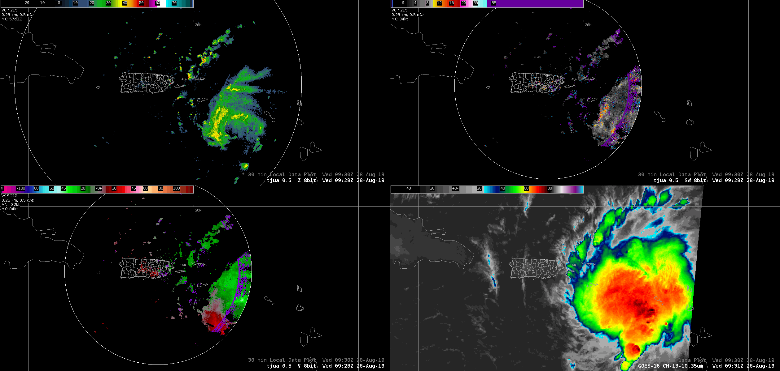
Figure 3: Loop of the TJUA NEXRAD from 0900 UTC - 2300 UTC on August 28, 2019 as Tropical Cyclone Dorian moves across the local area.
Presione aquí para retornar a la página principal del Servicio Nacional de Meteorología
|
Preliminary Rainfall Accumulations
|
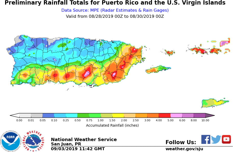
Figure 4: 48-hour rainfall accumulation from August 28, 2019 to August 30, 2019.
|
Maximum Wind Gust
|
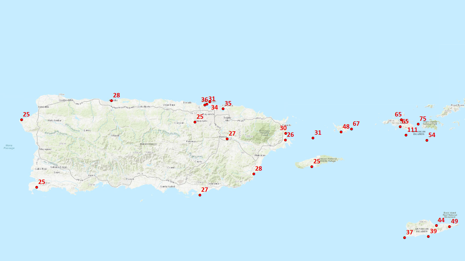
Figure 5: Maximum Wind Gust measured during the passage of Hurricane Dorian.
|
Marine Observations
|
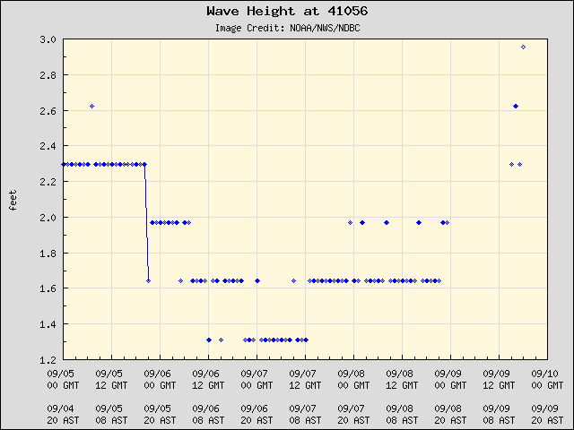
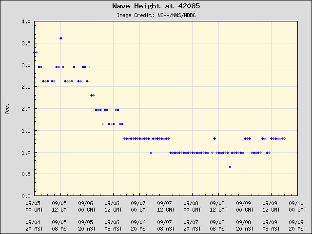
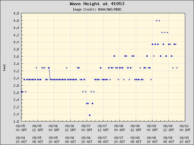
|
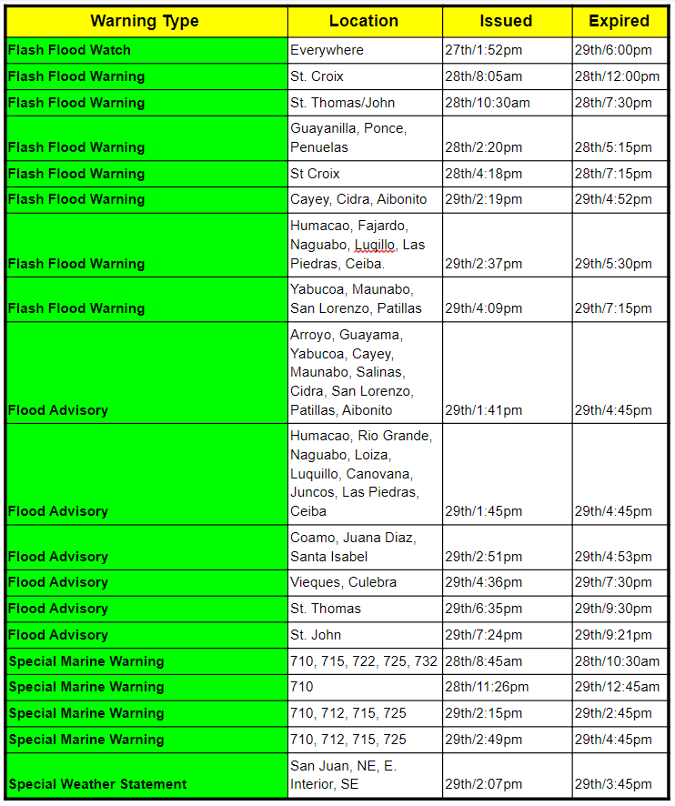
Watches and Warnings
|
Below is a summary of the Watches and Warnings from the NHC for our forecast area.
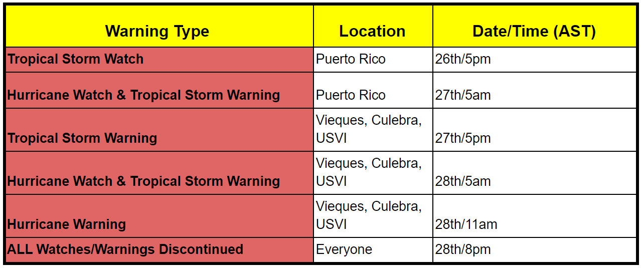
| Given that the storm directly hit the UVSI, and brushed by Puerto Rico, with the tail impacting the region the next day, many watches/warnings/advisories were issued by NWS San Juan for Wednesday and Thursday. They are the following: |
|
Damages
|
|
In the U.S. Virgin Islands, wind gusts over 100 mph were reported over the island of St. Thomas. These conditions generated more wind damage than expected, mainly over the southern and western portions of the island. Some roads were partially blocked by landslides across the islands of St. Thomas and St. John. Several trees were reported down by the winds. Also, utility poles and cables were affected by the hurricane-force winds generating power outages in parts of the islands. Several vessels were blown onshore in St. Thomas by Hurricane Dorian. The vulnerability of the island`s residents is still evident after the 2017 tropical season as many civilians are still living under tarps or temporary roofs. Many residents living in these conditions lost their temporary tarp roofs as a result of Dorian. In Puerto Rico, wind damage was not reported on August 28th. Most of the damage was associated with a trailing trough extending from Dorian that moved onshore on August 29th. Rainfall accumulations between 4 to 6 inches were reported mainly along the east and southeast portions of Puerto Rico. These showers and thunderstorms generated flash flooding, especially across the eastern end of Puerto Rico. |


 7-Day Graphical Hazardous Weather Outlook
 Tropical Analysis
 Tropical Weather
 Regional Satellite
 Puerto Rico and US Virgin Islands
 Local Radar