
Showers and thunderstorms will continue along and ahead of a cold front for the eastern third of the country. The rainfall for the Great Lakes region could prolong the ongoing flooding. Much cooler weather will filter in behind this cold front along and east of the Rockies. Where the rain is needed, the Southern High Plains, critical fire weather concerns through this weekend. Read More >
Cleveland CWSU
Center Weather Service Unit
 |
||
|
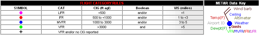
Click here for the latest regional surface plot.
|
 SIGMETS: ICE | TURB | IFR | CONV | ALL |
|
|---|
|
Cleveland Center Weather Service Unit (CWSU)
|
| Mission: Our main responsibility is to provide up to the minute weather information to FAA Supervisors and the ZOB Traffic Management Unit (TMU). Some of the products issued by the CWSU are the Center Weather Advisories (CWA) and the Meteorological Impact Statement (MIS). The CWA is an aviation weather warning for thunderstorms, severe icing or turbulence, and low IFR ceilings and visibility. The MIS is a 2-12 hour forecast for weather conditions, which are expected to impact ARTCC operations. |
|
US Dept of Commerce
National Oceanic and Atmospheric Administration
National Weather Service
Cleveland CWSU
Cleveland ARTCC Attn:CWSU
326 East Lorain Street
Oberlin, OH 44074
Comments? Questions? Please Contact Us.


