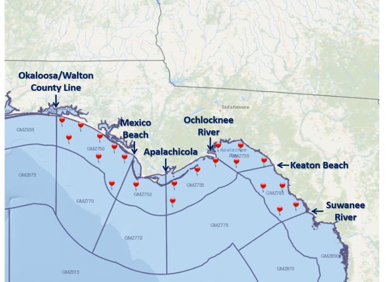
For a graphical forecast, visit weather.gov/beach/tae or see the county based surf zone forecast below:
Detailed Surf Zone Forecast
000
FZUS52 KTAE 200048
SRFTAE
Surf Zone Forecast
National Weather Service Tallahassee FL
847 PM EDT Sun May 19 2024
FLZ108-200800-
South Walton-
Including the beaches of Sandestin, Santa Rosa Beach,
and Turquoise Beach
747 PM CDT Sun May 19 2024
...HIGH RIP CURRENT RISK IN EFFECT UNTIL 3 AM CDT MONDAY...
.MONDAY...
Rip Current Risk............High.
Surf Height.................Around 2 feet.
Water Temperature...........80 degrees.
Weather.....................Sunny.
High Temperature............In the lower 80s.
Winds.......................Northeast winds around 10 mph, becoming
north in the afternoon.
Tides...
Panama City..............High at 08:14 AM EDT.
Sunrise.....................6:47 AM.
Sunset......................8:35 PM.
.TUESDAY...
Rip Current Risk............Moderate.
Surf Height.................Around 2 feet.
Weather.....................Sunny.
High Temperature............In the lower 80s.
Winds.......................East winds around 10 mph, becoming
southeast in the afternoon.
Tides...
Panama City..............High at 08:19 AM EDT.
Sunrise.....................6:47 AM.
Sunset......................8:36 PM.
.WEDNESDAY...Moderate rip current risk*. Surf height around 1 foot.
Sunny. Highs in the lower 80s. Southeast winds around 10 mph.
.THURSDAY...Moderate rip current risk*. Mostly sunny. Highs in the
lower 80s. Southeast winds around 10 mph.
.FRIDAY...Mostly sunny. Highs in the lower 80s. South winds around
10 mph.
&&
Rip Current Risk Category
* Low Risk - The risk for rip currents is low, however,
life-threatening rip currents often occur in the vicinity of groins,
jetties, reefs, and piers.
* Moderate Risk - Life-threatening rip currents are possible in the
surf zone.
* High Risk - Life-threatening rip currents are likely in the surf
zone.
** For lightning, waterspout, and UV definitions see:
https://www.weather.gov/beach/tae
$$
FLZ112-200800-
Coastal Bay-
Including the beaches of Panama City Beach and Magnolia Beach
747 PM CDT Sun May 19 2024
...HIGH RIP CURRENT RISK IN EFFECT UNTIL 3 AM CDT MONDAY...
.MONDAY...
Rip Current Risk............High.
Surf Height.................Around 2 feet.
Water Temperature...........80 degrees.
Weather.....................Sunny.
High Temperature............In the mid 80s.
Winds.......................Northeast winds around 10 mph, becoming
northwest in the afternoon.
Tides...
Panama City..............High at 08:14 AM EDT.
Sunrise.....................6:46 AM.
Sunset......................8:33 PM.
.TUESDAY...
Rip Current Risk............Moderate.
Surf Height.................Around 2 feet.
Weather.....................Sunny.
High Temperature............In the mid 80s.
Winds.......................East winds around 10 mph, becoming
south in the afternoon.
Tides...
Panama City..............High at 08:19 AM EDT.
Sunrise.....................6:45 AM.
Sunset......................8:33 PM.
.WEDNESDAY...Moderate rip current risk*. Surf height around 1 foot.
Sunny. Highs in the lower 80s. Southeast winds around 10 mph.
.THURSDAY...Moderate rip current risk*. Mostly sunny. Highs in the
lower 80s. Southeast winds around 10 mph.
.FRIDAY...Mostly sunny. Highs in the lower 80s. South winds around
10 mph.
&&
Rip Current Risk Category
* Low Risk - The risk for rip currents is low, however,
life-threatening rip currents often occur in the vicinity of groins,
jetties, reefs, and piers.
* Moderate Risk - Life-threatening rip currents are possible in the
surf zone.
* High Risk - Life-threatening rip currents are likely in the surf
zone.
** For lightning, waterspout, and UV definitions see:
https://www.weather.gov/beach/tae
$$
FLZ114-200800-
Coastal Gulf-
Including the beaches of Saint Joe Beach
747 PM CDT Sun May 19 2024
...HIGH RIP CURRENT RISK IN EFFECT UNTIL 3 AM CDT MONDAY...
.MONDAY...
Rip Current Risk...
W Facing Beaches.........High.
S Facing Beaches.........High.
State Park Beaches.......High.
Surf Height...
W Facing Beaches.........Around 2 feet.
S Facing Beaches.........Around 2 feet.
State Park Beaches.......Around 2 feet.
Water Temperature...........79 degrees.
Weather.....................Sunny.
High Temperature............In the lower 80s.
Winds.......................Northeast winds around 10 mph, becoming
southeast in the afternoon.
Tides...
Apalachicola.............Low at 08:20 AM EDT.
High at 01:46 PM EDT.
Sunrise.....................6:45 AM.
Sunset......................8:30 PM.
.TUESDAY...
Rip Current Risk...
W Facing Beaches.........Moderate.
S Facing Beaches.........Moderate.
State Park Beaches.......Moderate.
Surf Height...
W Facing Beaches.........Around 2 feet.
S Facing Beaches.........Around 2 feet.
State Park Beaches.......Around 2 feet.
Weather.....................Sunny.
High Temperature............In the lower 80s.
Winds.......................East winds around 10 mph.
Tides...
Apalachicola.............High at 05:11 AM EDT.
Low at 08:44 AM EDT.
High at 02:00 PM EDT.
Sunrise.....................6:45 AM.
Sunset......................8:31 PM.
.WEDNESDAY...Moderate rip current risk*. Surf height around 1 foot.
Sunny. Highs in the upper 70s. Southeast winds around 10 mph.
.THURSDAY...Moderate rip current risk*. Sunny. Highs in the lower
80s. Southeast winds around 5 mph.
.FRIDAY...Mostly sunny. Highs in the lower 80s. South winds around
5 mph.
&&
Rip Current Risk Category
* Low Risk - The risk for rip currents is low, however,
life-threatening rip currents often occur in the vicinity of groins,
jetties, reefs, and piers.
* Moderate Risk - Life-threatening rip currents are possible in the
surf zone.
* High Risk - Life-threatening rip currents are likely in the surf
zone.
** For lightning, waterspout, and UV definitions see:
https://www.weather.gov/beach/tae
$$
FLZ115-200800-
Coastal Franklin-
Including the beaches of Apalachicola
847 PM EDT Sun May 19 2024
...HIGH RIP CURRENT RISK IN EFFECT UNTIL 4 AM EDT MONDAY...
.MONDAY...
Rip Current Risk............High.
Surf Height.................Around 3 feet.
Water Temperature...........79 degrees.
Weather.....................Sunny.
High Temperature............Around 80.
Winds.......................Northeast winds around 10 mph.
Tides...
Apalachicola.............Low at 08:20 AM EDT.
High at 01:46 PM EDT.
Sunrise.....................6:43 AM.
Sunset......................8:29 PM.
.TUESDAY...
Rip Current Risk............Moderate.
Surf Height.................Around 2 feet.
Weather.....................Sunny.
High Temperature............Around 80.
Winds.......................East winds around 10 mph.
Tides...
Apalachicola.............Low at 08:44 AM EDT.
High at 02:00 PM EDT.
Sunrise.....................6:43 AM.
Sunset......................8:29 PM.
.WEDNESDAY...Moderate rip current risk*. Surf height around 1 foot.
Sunny. Highs in the upper 70s. Southeast winds around 10 mph.
.THURSDAY...Moderate rip current risk*. Sunny. Highs around 80.
Southeast winds around 5 mph.
.FRIDAY...Mostly sunny. Highs around 80. South winds around 5 mph.
&&
Rip Current Risk Category
* Low Risk - The risk for rip currents is low, however,
life-threatening rip currents often occur in the vicinity of groins,
jetties, reefs, and piers.
* Moderate Risk - Life-threatening rip currents are possible in the
surf zone.
* High Risk - Life-threatening rip currents are likely in the surf
zone.
** For lightning, waterspout, and UV definitions see:
https://www.weather.gov/beach/tae
$$


 Follow us on YouTube