April 4, 2011 Lincoln/Lawrence County Tornado
|
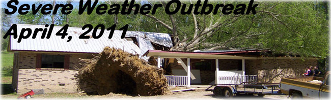
Event Summary The tornado started by downing trees along Cole Drive west of the Ruth community. The tornado quickly intensified and produced its first area of damage with winds estimated near 100 mph in Ruth. The awning of a gas station was destroyed, the volunteer fire department building had the back wall blown out, a church had the steeple blown off along with extensive shingle damage, and a number of homes suffered roof damage due to trees falling on them or due to direct minor roof damage. The tornado continued to move east across southeast Lincoln county and into southwest Lawrence county to the northwest and north of Jayess, causing tree damage. A few trees here fell on homes, and one fell on an RV vehicle, completely destroying it. After appearing to weaken northeast of Jayess, the tornado restrengthened after moving east of Mississippi Highway 27. The tornado again caused damaging indicative of winds of 100 mph along Tom Sistrunk road. Numerous large trees were snapped and uprooted, and several homes had minor to moderate roof damage. The tornado then weakened as it moved east, dissipating just before reaching the border between Lawrence and Marion counties. While the damage pattern associated with this tornado had clear tornadic indications with a convergent damage pattern, there was also damage indicative of straight line winds to the west and north of the tornado, primarily from west to north of Ruth. A number of trees were downed in this area, some on power lines. |
|


 Follow us on YouTube