Jones/Jasper County Tornado
|
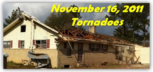
Event Summary The tornado developed along Pat Holliman and Leroy Hill Roads, downing a few trees. The tornado moved northeast, widened and reached its maximum width in the area of Springhill Road, where high end EF-1 damage to trees occurred. The tornado then narrowed to about 150 to 250 yard wide path of mid to high end EF-2 damage on either side of State Highway 15 in the Shady Grove community northwest of Laurel. Several mobile homes were completely destroyed, numerous power poles were snapped, several frame and brick homes suffered major damage and other moderate damage, and extensive tree damage occurred. A few commercial buildings along State Highway 15 suffered major damage. As the tornado continued northeast across northeast Jones County, it caused EF-1 type damage as it crossed Sharon-Moss and Lake Como Roads, snapping and uprooting trees and causing some roof and minor structural damage to several homes. The tornado then intensified somewhat again as it crossed into Jasper County, destroying three large chicken houses and causing extensive tree damage along County Road 812 just inside the Jasper County line. The tornado dissipated shortly after causing this damage. So far, 15 people were injured by this tornado, with nearly all of the injuries being relatively minor. |
|


 Follow us on YouTube