|
Key Indicators in Warning Decisions
No one example listed here is used to issue a warning. It usually takes a combination of any number of these examples, along with the environmental conditions at the time of the storm. Click to enlarge the animation or image.
|
|
Three Body Scatter Spikes (TBSSs)
While analyzing radar data during severe weather, most features, such as tornadoes, have to be inferred. In other words, the radar does not have the capability to specifically show a tornado on the ground. It is impossible.
TBSSs are the only direct indictator of anything seen on the radar. TBSSs specifically show that there is the formation of hail in a thunderstorm.
For more information on TBSSs, please read Les Lemon's research on the topic.
|
 |
|
Three Body Scatter Spike or Hail Spike
|
|
|
Outflow Boundary
Outflow boundaries play an important role in warning decision making because they have the ability to increase the strength of any given feature. From the most extreme, when they can enhance vorticity in the atmosphere making the formation of tornadoes possible, to the just increasing the intensity of an individual thunderstorm. There are other types of boundaries which create the same effect, such as sea breezes and cold fronts.
In this animation, a thunderstorm in the lower right corner (moving to the north), puts out an outflow boundary which is depicted by the blue and green arcing "wave" which pushes out to the northwest ahead of the storm. Notice as it nears the radar (the black circle) the explosion of reflectivity associated with a newly formed thunderstorm.
|
 |
|
Outflow Boundary
|
|
|
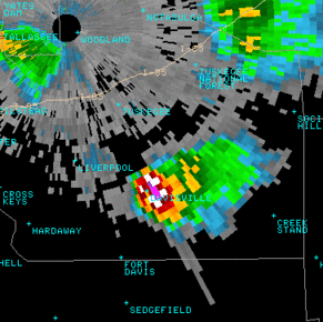
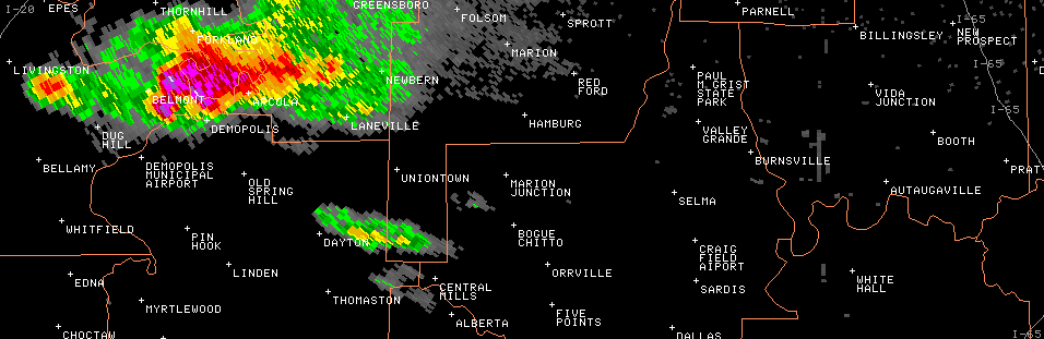
Hook Echos
A hook echo is a region of a supercell thunderstorm where tornado formation can occur. Usually found on the south or southwest side of a supercell, hook echoes are a good indication that the updraft in the thunderstorm is very strong. Though it is possible, a hook echo does not mean that a tornado is on the ground.
This example of a hook echo was part of a long-lived supercell thunderstorm that travelled from Livingston to Montgomery on February 18th, 2009. This supercell did not produce a tornado, but it did produce softball sized hail.
|
 |
|
Hook Echo
|
|
|
Rotational Couplets
A common phrase in severe weather operations, rotational couplets are found in the velocity data from a doppler radar. To read about what the colors mean click here .
When a thunderstorm is in the mature stage of its life cycle, the updraft in the storm is strong and there is wind shear present in the environment, rotational couplets can be seen in the mid-levels of the storm. These are known as a mesocyclones and they are indicators of a well organized storm.
If the storm continues to strengthen, rotational couplets can be seen in multiple levels of a storm. While analyzing radar data, if rotational couplets are seen at multiple levels in a storm and they persist for 10 or more minutes, tornado formation is possible, and a tornado warning is imminent.
This example of a rotational couplet was part of the same supercell thunderstorm that travelled from Livingston to Montgomery on February 18th, 2009. This supercell did not produce a tornado, but it did produce softball sized hail.
|
 |
|
Rotational Couplet
|
|
|
Storm Top Divergence
Along with Rotational Couplets, Storm Top Divergence is an indicator of how strong a storm has become. Once the updraft in a thunderstorm reaches the tropopause, it can no longer go any higher in elevation. In turn, it spreads out at the top of the thunderstorm into what is called the anvil. The intensity of this spreading is measurable on radar using velocity data.
Measured by adding the intensity of the inbound velocities and the outbound velocities, most studies have concluded that 75 knots of Storm Top Divergence is enough to sustain hail growth large enough to meet severe criteria (3/4 inch).
This example of Storm Top Divergence over Coosa County on June 28, 2009, illustrates 124 knots of divergence at 54,000 feet. Though no hail or wind damage was reported with this storm (very rural area), this storm was by far the strongest of the day in central Alabama.
|
 |
|
Storm Top Divergence
|
|
|


 Follow us on YouTube