Central Alabama Snowfall
January 19, 2008
Snowfall across Central Alabama is hard to come by, and it takes a perfect combination moisture and cold temperatures to produce it. Even when it becomes likely that all of the ingredients will be in place for snow, it is usually quite difficult to pinpoint what areas will get the most snow, and how much each area will get.
The signs for a potential winter weather event on Saturday, January 19th, started to come into focus earlier in the week. Some computer models predicted very heavy snow for North Alabama, while other models predicted somewhat smaller snowfall potential farther to the south. Once again, the big questions would be: 1.) How far north would the really deep moisture needed for snow get, and 2.) Would the cold air from an advancing arctic air mass reach the state before the precipitation moved out?
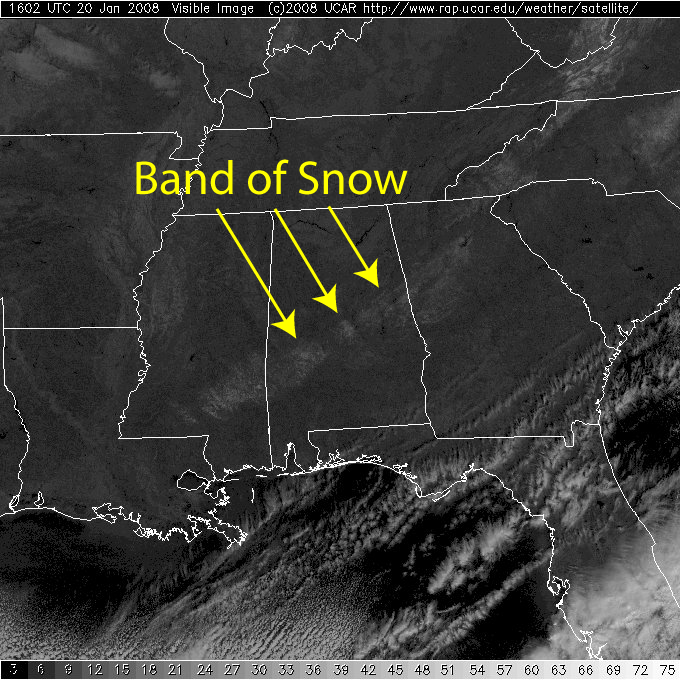
The rain started moving into Central Alabama the evening of Friday, January 18th. There was a bit of sleet and snow mixed in with the rain during the overnight hours on January 18th into the early morning of Saturday, January 19th. After a brief lull in the precipitation, the cold air and another batch of moisture met up just perfectly to produce a swath of accumulating snow across the middle of the state during the early daylight hours. This swath was bounded roughly by Interstate 20 on the north side, and Interstate 85 on the south side. The highest totals were in a narrower band, from Sumter and Marengo Counties, north-eastward up to Chilton and Coosa Counties. (See the map below.) The snow finally tapered off across the state around noon to 1 PM.
Because ground temperatures were just above freezing, much of the snow outside of the highest snow band melted within an hour or two after the snow ended, but not before kids of all ages in many areas were able to go out and play in a rare Central Alabama snow storm.
Click Here for Area Snowfall Reports
Click for Larger Images


 Follow us on YouTube