Overview
|
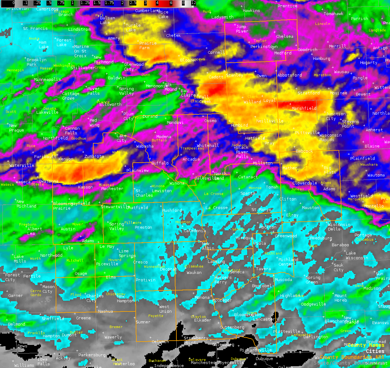
In what was already a very active week for severe weather, the night of the 19th (Friday) through the day on the 20th (Saturday) brought 3 more rounds of strong to severe storms. The main impacts were from damaging winds, a few brief tornadoes, and heavy rain resulting in flooding. Late Friday night (July 19th), a complex of thunderstorms tracked southeast across northwest Wisconsin, bringing damaging winds (60 to 70 mph), several tornadoes, and very heavy rainfall. The bulk of the storms stayed north of Interstate 94. The next cluster of strong to severe storms rolled into southeast Minnesota around 7 am Saturday (July 20th), bringing strong to damaging winds and heavy rain. The rainfall led to some flash flooding. In addition, two brief tornadoes occurred in Trempealeau and Jackson Counties in Wisconsin. By late morning, another thunderstorm complex was already approaching from the west, tracking along a surface front that played a roll in firing the storms from Friday night and early Saturday morning. This complex developed into a northeast-southwest running line, bringing damaging winds from 60 to 75 mph through the area. The strongest winds and most of the related damage held south of Interstate 94. Rain was not as heavy with this cluster. |
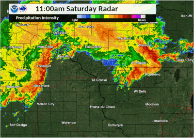 Radar Loop From "3rd" Wave Of Storms Late Sat Morning-Afternoon |
Tornadoes:
|
|
||||||||||
|
||||||||||
|
Tornado - Withee 4 W
|
||||||||||||||||
|
Tornado - Withee 2NNW
|
||||||||||||||||
|
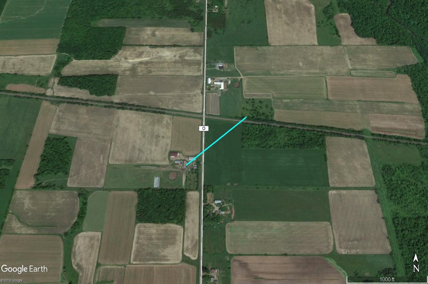
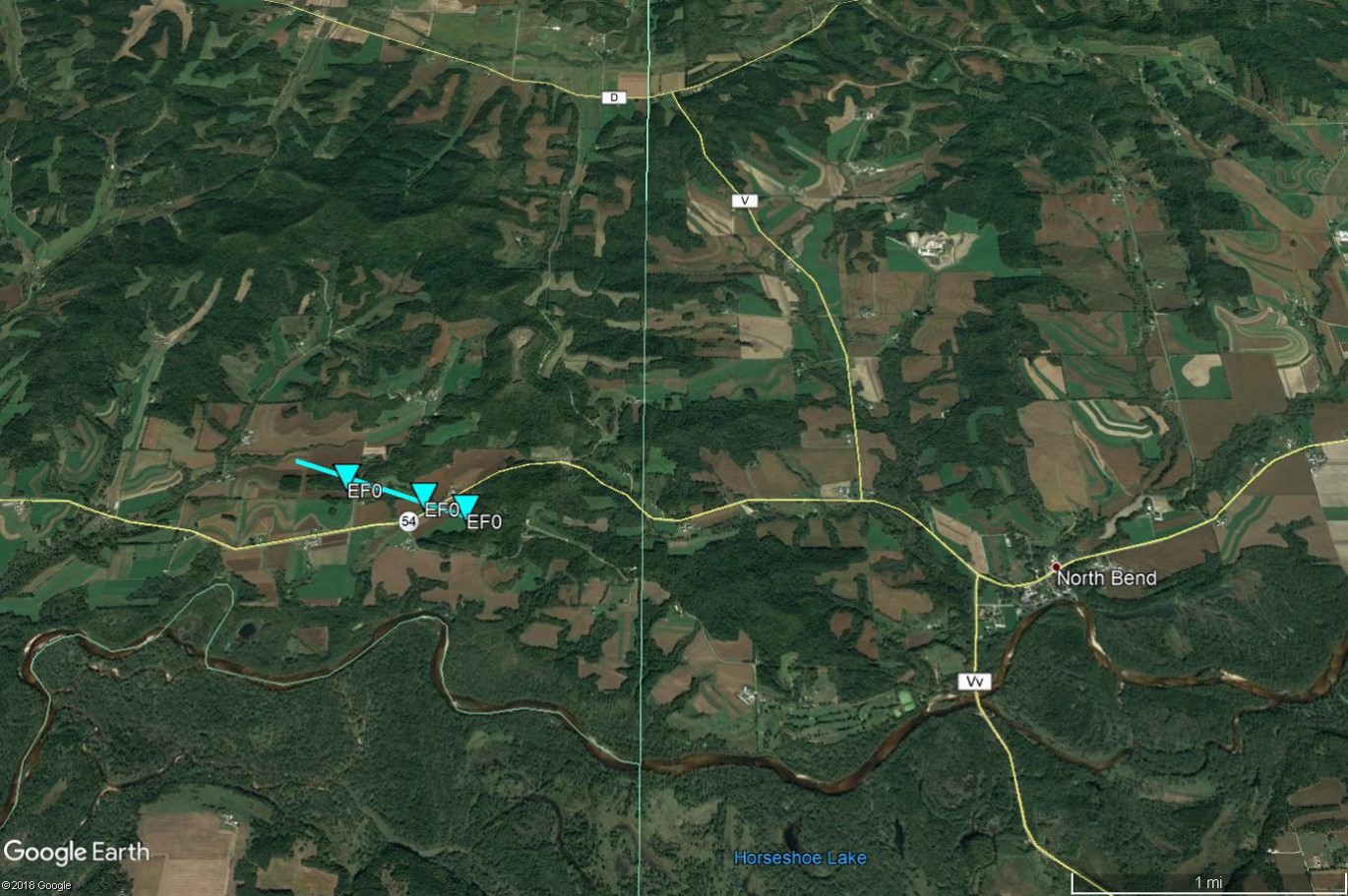
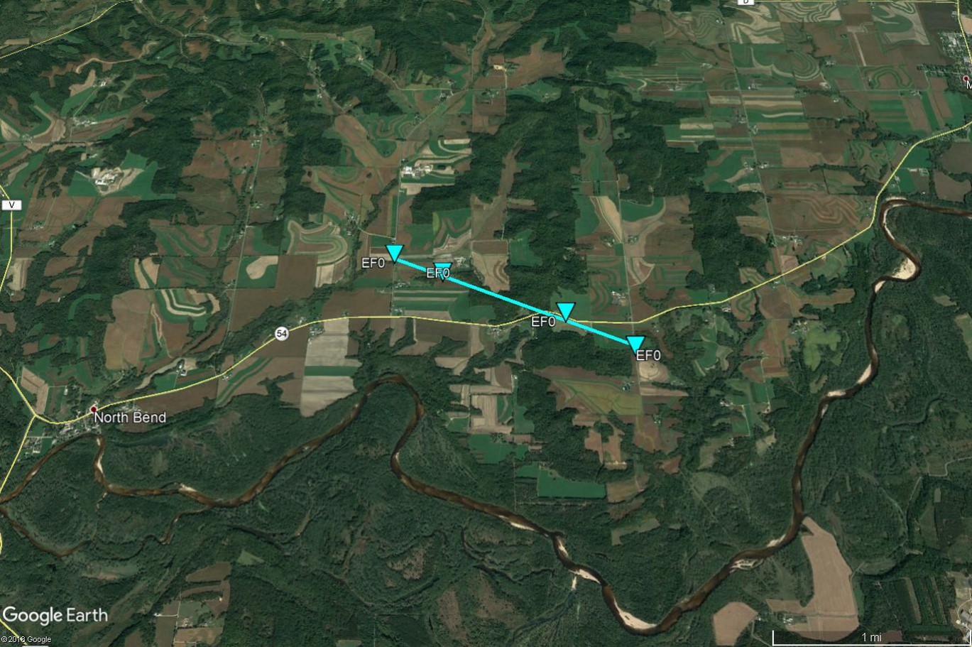
Tornado - North Bend 3.1W
|
||||||||||||||||
|
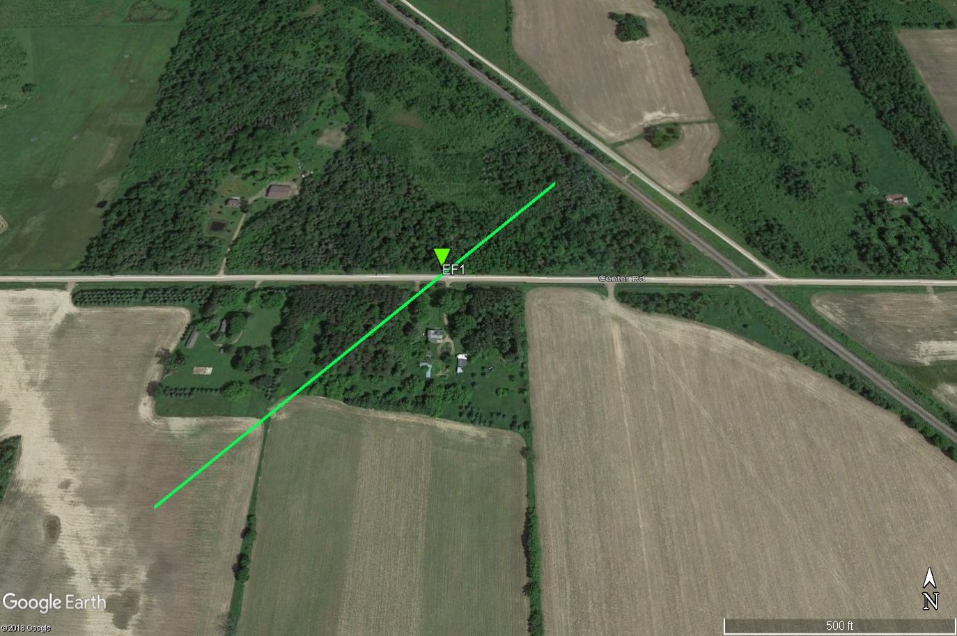
Tornado - North Bend 2NE
|
||||||||||||||||
The Enhanced Fujita (EF) Scale classifies tornadoes into the following categories:
| EF0 Weak 65-85 mph |
EF1 Moderate 86-110 mph |
EF2 Significant 111-135 mph |
EF3 Severe 136-165 mph |
EF4 Extreme 166-200 mph |
EF5 Catastrophic 200+ mph |
 |
|||||
Wind:
Wind
Public Information Statement
National Weather Service La Crosse WI
626 PM CDT Sat Jul 20 2019

...Strongest Wind Gusts Today...

Location                     Speed     Time/Date       Lat/Lon

...Iowa...

...Fayette County...
Oelwein Municipal Airport    44 MPH    1255 PM 07/20   42.67N/91.97W

...Floyd County...
Charles City Airport         54 MPH    1155 AM 07/20   43.07N/92.62W

...Winneshiek County...
5 NW Frankville              47 MPH    1241 PM 07/20   43.25N/91.70W
Decorah Municipal Airport    46 MPH    1235 PM 07/20   43.27N/91.72W

...Minnesota...

...Dodge County...
2 E Kasson                   54 MPH    0850 AM 07/20   44.02N/92.71W
Dodge Center                 53 MPH    1115 AM 07/20   44.02N/92.82W

...Fillmore County...
2 ESE Canton                 48 MPH    1220 PM 07/20   43.52N/91.89W
Preston Airport              47 MPH    1155 AM 07/20   43.68N/92.17W

...Mower County...
Austin Municipal Airport     48 MPH    1115 AM 07/20   43.67N/92.92W

...Olmsted County...
Rochester International Airp 74 MPH    0757 AM 07/20   43.90N/92.50W
3 N Stewartville             54 MPH    0905 AM 07/20   43.90N/92.48W
Mayo Helipad                 52 MPH    0855 AM 07/20   44.02N/92.48W
Jct CR 7 I-90 Mile Post 226  50 MPH    1150 AM 07/20   43.96N/92.21W
Byron                        48 MPH    1130 AM 07/20   44.04N/92.64W

...Wabasha County...
1 SSE Kellogg                41 MPH    0920 AM 07/20   44.28N/91.99W
Lake City                    40 MPH    1132 AM 07/20   44.32N/92.44W

...Winona County...
Winona Municipal Airport     35 MPH    0855 AM 07/20   44.07N/91.70W

...Wisconsin...

...Crawford County...
Prairie Du Chien  Airport    47 MPH    0115 PM 07/20   43.02N/91.12W

...Grant County...
Boscobel                     48 MPH    0203 PM 07/20   43.15N/90.68W
Platteville Municipal Airpor 36 MPH    0215 PM 07/20   42.68N/90.43W

...Jackson County...
Black River Falls Area Airpo 40 MPH    0935 AM 07/20   44.25N/90.85W
1 E Black River Falls        38 MPH    1015 AM 07/20   44.30N/90.73W

...Juneau County...
Mauston Airport              37 MPH    0135 PM 07/20   43.83N/90.13W

...La Crosse County...
La Crosse Regional Airport   52 MPH    1238 PM 07/20   43.88N/91.25W
St. Joseph 3W                40 MPH    1254 PM 07/20   43.78N/91.10W

...Taylor County...
3 NE Lublin                  48 MPH    0814 PM 07/19   45.11N/90.69W
Medford Airport              39 MPH    0115 PM 07/20   45.10N/90.30W

Observations are collected from a variety of sources with varying
equipment and exposures. We thank all volunteer weather observers
for their dedication. Not all data listed are considered official.

$$
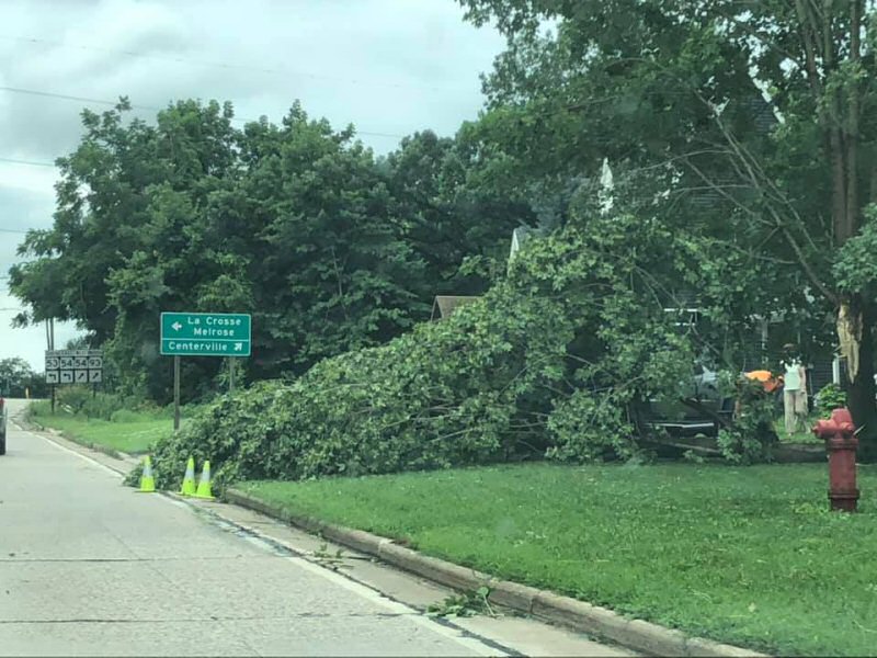
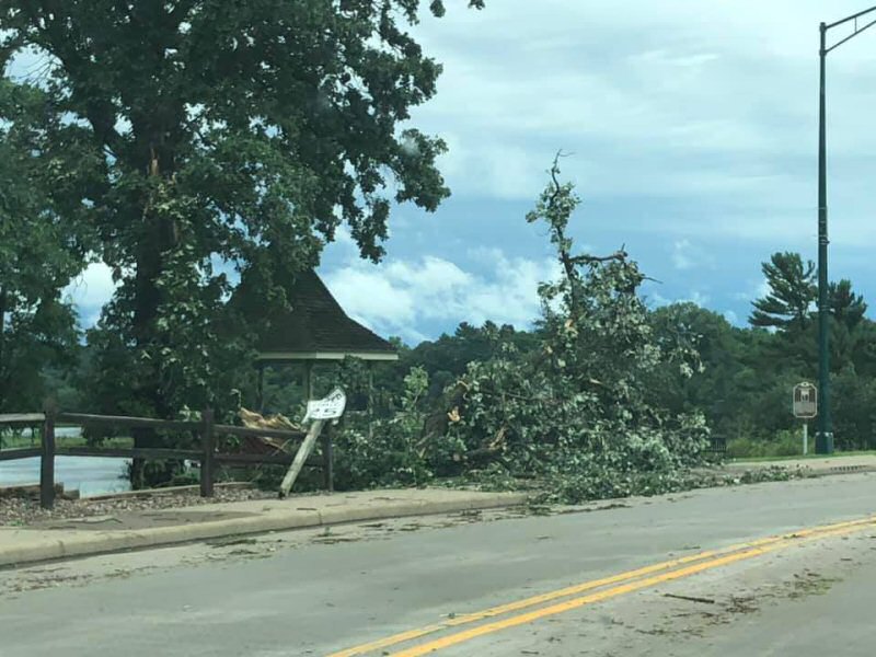
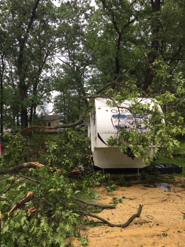
Photos & Video:
Saturday morning
 |
 |
 |
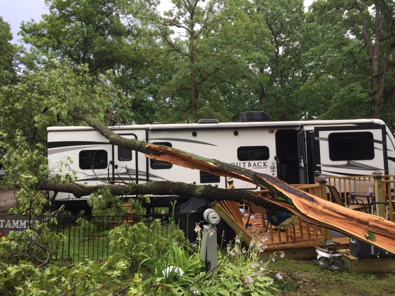 |
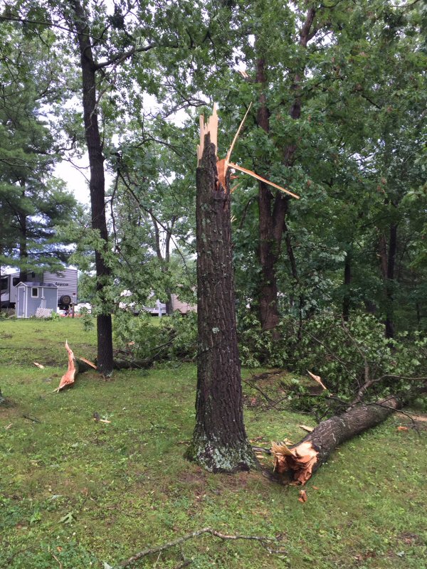
| Galesville (Hanah Fredrickson) |
Galesville (Hanah Fredrickson) |
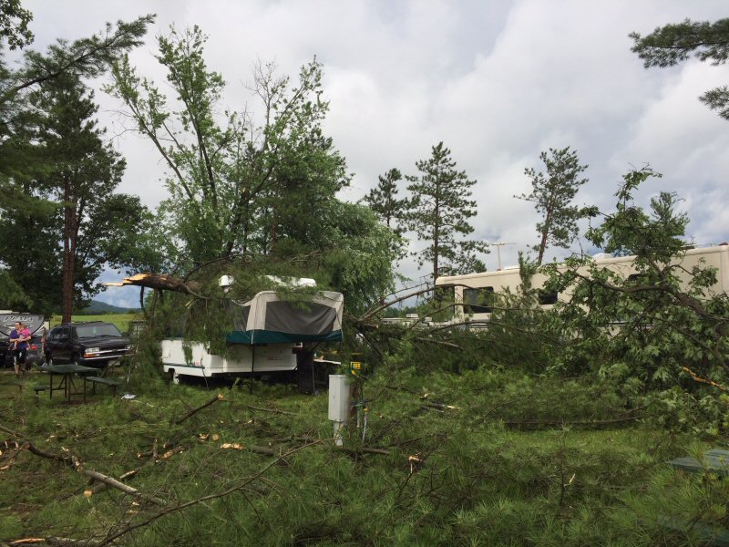
Champions Campground (NWS La Crosse) |
Champions Campground (NWS La Crosse) |
 |
 |
 |
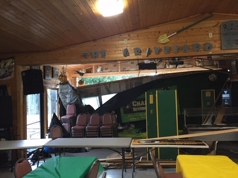 |
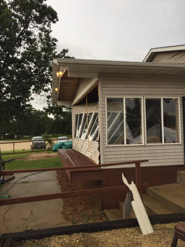
| Champions Campground (NWS La Crosse) |
Champions Campground (NWS La Crosse) |
Champions Campground (NWS La Crosse) |
Champions Campground (NWS La Crosse) |
Radar:
Storm Reports
PRELIMINARY LOCAL STORM REPORT...SUMMARY
NATIONAL WEATHER SERVICE LA CROSSE WI
824 PM CDT SAT JUL 20 2019

..TIME...   ...EVENT...      ...CITY LOCATION...     ...LAT.LON...
..DATE...   ....MAG....      ..COUNTY LOCATION..ST.. ...SOURCE....
            ..REMARKS..

0857 AM     TSTM WND GST     3 NNW STEWARTVILLE      43.90N 92.50W
07/20/2019  M74 MPH          OLMSTED            MN   ASOS

            ASOS STATION KRST ROCHESTER INTERNATIONAL
            AIRPORT.

0857 AM     TSTM WND DMG     GALESVILLE              44.08N 91.36W
07/20/2019                   TREMPEALEAU        WI   PUBLIC

            DELAYED REPORT. MULTIPLE TREES AND BRANCHES
            DOWN IN GALESVILLE. RELAYED VIA SOCIAL
            MEDIA. TIME ESTIMATED FROM RADAR.

0900 AM     TSTM WND DMG     4 ESE GALESVILLE        44.06N 91.29W
07/20/2019                   TREMPEALEAU        WI   NWS EMPLOYEE

            DELAYED REPORT. NUMEROUS REPORTS OF TREES
            DOWN. TIME ESTIMATED FROM RADAR.

0936 AM     TSTM WND DMG     1 W LAKE ARBUTUS        44.43N 90.71W
07/20/2019                   CLARK              WI   PUBLIC

            NUMEROUS TREES DOWN BETWEEN HATFIELD AND
            NEILLSVILLE. TIME ESTIMATED FROM RADAR.

0950 AM     TSTM WND GST     GREENWOOD               44.77N 90.60W
07/20/2019  E50 MPH          CLARK              WI   PUBLIC

            ESTIMATED 50 MPH WINDS.

0958 AM     TSTM WND DMG     1 SW NEILLSVILLE        44.56N 90.60W
07/20/2019                   CLARK              WI   EMERGENCY MNGR

            REPORT OF A SEMI TRUCK BLOWN OFF HIGHWAY 10.

1002 AM     TSTM WND GST     ALMA CENTER             44.44N 90.91W
07/20/2019  E50 MPH          JACKSON            WI   PUBLIC

            NUMEROUS MEDIUM AND SMALL BRANCHES DOWN ON
            MULTIPLE ROADS.

1008 AM     TSTM WND DMG     1 SE RIPLINGER          44.82N 90.39W
07/20/2019                   CLARK              WI   TRAINED SPOTTER

            VERY STRONG WINDS. ESTIMATED 60 MPH OR
            GREATER. SOME ROOF DAMAGE AND MANY TREES
            DOWN.

1012 AM     TSTM WND DMG     3 SW SPENCER            44.71N 90.34W
07/20/2019                   CLARK              WI   TRAINED SPOTTER

            1 TO 1.5 FT DIAMETER TREE DOWN. TIME
            ESTIMATED FROM RADAR.

1100 AM     HEAVY RAIN       4 ESE DOUGLAS           44.08N 92.51W
07/20/2019  M2.80 INCH       OLMSTED            MN   PUBLIC


1122 AM     TSTM WND DMG     WALTHAM                 43.82N 92.88W
07/20/2019                   MOWER              MN   PUBLIC

            SOCIAL MEDIA PHOTOS OF TREES DOWN. RELAYED
            VIA BROADCAST MEDIA.

1124 AM     TSTM WND DMG     1 NW AUSTIN             43.68N 92.98W
07/20/2019                   MOWER              MN   PUBLIC

            LARGE TREE DOWN IN NORTHWEST AUSTIN. SOCIAL
            MEDIA PHOTO RELAYED BY BROADCAST MEDIA.

1124 AM     TSTM WND DMG     BYRON                   44.03N 92.65W
07/20/2019                   OLMSTED            MN   PUBLIC

            TREE UPROOTED. RELAYED VIA BROADCAST MEDIA.
            TIME ESTIMATED FROM RADAR.

1132 AM     TSTM WND DMG     4 NNW ROCHESTER         44.06N 92.50W
07/20/2019                   OLMSTED            MN   PUBLIC

            SOCIAL MEDIA PHOTO OF LARGE PORTION OF TREE
            DOWN. RELAYED VIA BROADCAST MEDIA. TIME
            ESTIMATED FROM RADAR.

1134 AM     TSTM WND DMG     STACYVILLE              43.44N 92.78W
07/20/2019                   MITCHELL           IA   EMERGENCY MNGR

            TREE BLOWN DOWN.

1142 AM     TSTM WND GST     1 N OSAGE               43.30N 92.81W
07/20/2019  M55 MPH          MITCHELL           IA   EMERGENCY MNGR


1149 AM     TSTM WND DMG     CHARLES CITY            43.07N 92.67W
07/20/2019                   FLOYD              IA   PUBLIC

            PHOTO OF TREE DOWN ON HOUSE. RELAYED VIA
            BROADCAST MEDIA. TIME ESTIMATED FROM RADAR.

1157 AM     TSTM WND GST     COLWELL                 43.16N 92.59W
07/20/2019  E50 MPH          FLOYD              IA   TRAINED SPOTTER


1204 PM     TSTM WND GST     1 NW CRESCO             43.38N 92.13W
07/20/2019  M40 MPH          HOWARD             IA   PUBLIC


1232 PM     FLASH FLOOD      OXBOW PARK              44.08N 92.65W
07/20/2019                   OLMSTED            MN   EMERGENCY MNGR

            WATER OVER ROADS IN RURAL NORTHWEST OLMSTED
            CO. LEVELS STILL RISING.

1235 PM     TSTM WND GST     1 N ONALASKA            43.90N 91.23W
07/20/2019  M39 MPH          LA CROSSE          WI   TRAINED SPOTTER

            .

1235 PM     TSTM WND GST     2 E DECORAH             43.31N 91.75W
07/20/2019  M46 MPH          WINNESHIEK         IA   AWOS


1248 PM     HEAVY RAIN       MANTORVILLE             44.07N 92.76W
07/20/2019  M6.00 INCH       DODGE              MN   BROADCAST MEDIA

            RELAYED VIA BROADCAST MEDIA.

1254 PM     TSTM WND DMG     ROCKLAND                43.91N 90.92W
07/20/2019                   LA CROSSE          WI   PUBLIC

            PHOTOS OF TREES DOWN. RELAYED VIA BROADCAST
            MEDIA.

1258 PM     TSTM WND DMG     2 N ELKADER             42.88N 91.40W
07/20/2019                   CLAYTON            IA   LAW ENFORCEMENT

            A FEW TREES DOWN ON POWER LINES.

0101 PM     HEAVY RAIN       1 NE KASSON             44.04N 92.74W
07/20/2019  M1.72 INCH       DODGE              MN   TRAINED SPOTTER

            MEASURED BETWEEN 1025 AM AND 1230 PM.

0115 PM     TSTM WND GST     1 SE PRAIRIE DU CHIEN   43.03N 91.13W
07/20/2019  M47 MPH          CRAWFORD           WI   AWOS


0124 PM     TSTM WND GST     BOSCOBEL                43.14N 90.70W
07/20/2019  M38 MPH          GRANT              WI   ASOS


0125 PM     TSTM WND DMG     4 N ROCKBRIDGE          43.50N 90.37W
07/20/2019                   RICHLAND           WI   EMERGENCY MNGR

            TREES KNOCKED DOWN. TIME ESTIMATED FROM
            RADAR.

0147 PM     TSTM WND GST     8 ESE FENNIMORE         42.94N 90.50W
07/20/2019  E55 MPH          GRANT              WI   TRAINED SPOTTER

            VARIOUS WIND GUSTS OF 52 TO 55 MPH.

0148 PM     TSTM WND GST     LONE ROCK               43.18N 90.20W
07/20/2019  M55 MPH          RICHLAND           WI   ASOS


0155 PM     TSTM WND GST     KIELER                  42.58N 90.60W
07/20/2019  E50 MPH          GRANT              WI   FIRE DEPT/RESCUE

            REPORTED IN JAMESTOWN AREA AS WELL.

0200 PM     HEAVY RAIN       BUFFALO                 44.23N 91.86W
07/20/2019  M1.98 INCH       BUFFALO            WI   AMATEUR RADIO

            .

0244 PM     HEAVY RAIN       MANTORVILLE             44.07N 92.76W
07/20/2019  M4.10 INCH       DODGE              MN   PUBLIC


0300 PM     HEAVY RAIN       1 WNW MANTORVILLE       44.07N 92.77W
07/20/2019  M4.07 INCH       DODGE              MN   CO-OP OBSERVER

            CO-OP OBSERVER STATION MVLM5 MANTORVILLE.

0315 PM     HEAVY RAIN       6 E BLACK RIVER FALLS   44.30N 90.73W
07/20/2019  M2.13 INCH       JACKSON            WI   MESONET

            MESONET STATION BFWW3 1 E BLACK RIVER FALLS.

0400 PM     HEAVY RAIN       1 NNE BYRON             44.04N 92.64W
07/20/2019  M1.98 INCH       OLMSTED            MN   MESONET

            MESONET STATION EW5820 BYRON.

0401 PM     HEAVY RAIN       3 SSW HAMMOND           44.18N 92.41W
07/20/2019  M2.06 INCH       OLMSTED            MN   MESONET

            MESONET STATION EW7548 ROCHESTER.

0410 PM     HEAVY RAIN       4 ESE DOUGLAS           44.09N 92.51W
07/20/2019  M2.95 INCH       OLMSTED            MN   MESONET

            MESONET STATION AU624 ROCHESTER.

0411 PM     HEAVY RAIN       3 ESE DOUGLAS           44.08N 92.52W
07/20/2019  M2.23 INCH       OLMSTED            MN   MESONET

            MESONET STATION FW3896 ROCHESTER.

0412 PM     HEAVY RAIN       PLAINVIEW               44.17N 92.17W
07/20/2019  M2.23 INCH       WABASHA            MN   MESONET

            MESONET STATION AV025 PLAINVIEW.

0413 PM     HEAVY RAIN       1 W BYRON               44.03N 92.66W
07/20/2019  M2.24 INCH       OLMSTED            MN   MESONET

            MESONET STATION EW7238 BYRON.

0414 PM     HEAVY RAIN       PLAINVIEW               44.16N 92.17W
07/20/2019  M2.05 INCH       WABASHA            MN   MESONET

            MESONET STATION PLNVW PLAINVIEW.

0414 PM     HEAVY RAIN       3 NE LUBLIN             45.11N 90.69W
07/20/2019  M2.16 INCH       TAYLOR             WI   MESONET

            MESONET STATION DMLW3 3 NE LUBLIN.

0605 PM     HEAVY RAIN       1 N WABASHA             44.38N 92.04W
07/20/2019  M2.40 INCH       WABASHA            MN   PUBLIC

            .


&&
Rain Reports
Public Information Statement
National Weather Service La Crosse WI
819 PM CDT Sat Jul 20 2019

...24 Hour Rainfall Reports...

Location                     Amount    Time/Date       Lat/Lon

...Iowa...

...Clayton County...
Turkey River                 0.14 in   0300 PM 07/20   42.74N/91.26W
Monona                       0.13 in   0414 PM 07/20   43.04N/91.39W
Big Spring Fish Hatchery     0.13 in   0315 PM 07/20   42.91N/91.47W
Mcgregor                     0.11 in   0414 PM 07/20   43.02N/91.19W

...Floyd County...
Charles City Airport         0.33 in   0700 PM 07/20   43.07N/92.62W

...Howard County...
Riceville                    0.48 in   0401 PM 07/20   43.40N/92.50W
Saratoga                     0.46 in   0415 PM 07/20   43.35N/92.42W

...Mitchell County...
St.Ansgar                    0.33 in   0408 PM 07/20   43.38N/92.92W

...Winneshiek County...
1 ENE Jackson Junction       0.40 in   0415 PM 07/20   43.11N/92.04W
Decorah Municipal Airport    0.30 in   0700 PM 07/20   43.27N/91.72W
Decorah                      0.25 in   0414 PM 07/20   43.30N/91.79W

...Minnesota...

...Dodge County...
Mantorville                  4.10 in   0244 PM 07/20   44.07N/92.76W
Mantorville                  4.07 in   0300 PM 07/20   44.07N/92.77W

...Houston County...
Houston                      0.47 in   0410 PM 07/20   43.79N/91.59W

...Olmsted County...
Rochester                    2.95 in   0410 PM 07/20   44.09N/92.51W
Byron                        2.24 in   0413 PM 07/20   44.03N/92.66W
Rochester                    2.23 in   0411 PM 07/20   44.08N/92.52W
Rochester                    2.06 in   0401 PM 07/20   44.18N/92.41W
Byron                        1.98 in   0400 PM 07/20   44.04N/92.64W
Rochester                    1.74 in   0413 PM 07/20   44.01N/92.49W
Rochester                    1.63 in   0415 PM 07/20   44.05N/92.45W
South Fork Zumbro River      1.57 in   0300 PM 07/20   44.06N/92.47W
Rochester-Beltline Bear Cree 1.55 in   0315 PM 07/20   44.01N/92.45W
Mayo Helipad                 1.09 in   0416 PM 07/20   44.02N/92.48W
Rochester International Airp 0.88 in   0700 PM 07/20   43.90N/92.50W

...Wabasha County...
Plainview                    2.23 in   0412 PM 07/20   44.17N/92.17W
Plainview                    2.05 in   0414 PM 07/20   44.16N/92.17W
Wabasha                      1.64 in   0413 PM 07/20   44.30N/92.00W
Lake City                    1.04 in   0412 PM 07/20   44.32N/92.44W
Lake City                    0.77 in   0400 PM 07/20   44.45N/92.27W

...Winona County...
North Fork Whitewater River  1.28 in   0345 PM 07/20   44.09N/92.03W
Winona Municipal Airport     0.92 in   0700 PM 07/20   44.07N/91.70W
Mississippi River Control Po 0.60 in   0300 PM 07/20   43.91N/91.36W

...Wisconsin...

...Buffalo County...
Cochrane                     1.70 in   0414 PM 07/20   44.22N/91.83W

...Crawford County...
De Soto                      0.14 in   0411 PM 07/20   43.42N/91.19W

...Grant County...
Platteville Municipal Airpor 0.47 in   0700 PM 07/20   42.68N/90.43W
Muscoda                      0.39 in   0410 PM 07/20   43.19N/90.46W
Boscobel Airport             0.21 in   0700 PM 07/20   43.15N/90.68W
Boscobel                     0.19 in   0403 PM 07/20   43.15N/90.68W

...Jackson County...
1 E Black River Falls        2.13 in   0315 PM 07/20   44.30N/90.73W

...Juneau County...
Mauston                      0.53 in   0412 PM 07/20   43.80N/90.07W

...La Crosse County...
La Crosse Regional Airport   0.54 in   0700 PM 07/20   43.88N/91.25W
1 SE La Crosse               0.43 in   0657 PM 07/20   43.81N/91.22W
St. Joseph 3W                0.40 in   0414 PM 07/20   43.78N/91.10W
La Crosse                    0.28 in   0415 PM 07/20   43.77N/91.22W

...Monroe County...
2 E Cataract                 1.02 in   0413 PM 07/20   44.09N/90.79W

...Taylor County...
3 NE Lublin                  2.16 in   0414 PM 07/20   45.11N/90.69W
Medford                      1.21 in   0401 PM 07/20   45.30N/90.30W
Medford Airport              1.24 in   0700 PM 07/20   45.10N/90.30W

...Trempealeau County...
Galesville 1.0 NE            1.54 in   0300 PM 07/20   44.10N/91.34W
Trempealeau                  0.68 in   0413 PM 07/20   44.07N/91.51W

Observations are collected from a variety of sources with varying
equipment and exposures. We thank all volunteer weather observers
for their dedication. Not all data listed are considered official.

$$
 |
Media use of NWS Web News Stories is encouraged! Please acknowledge the NWS as the source of any news information accessed from this site. |
|