
A stationary front will continue to bring heavy to excessive rainfall to South Florida into Saturday with localized and urban flooding possible. Heavy to excessive rainfall is forecast through Saturday over the southern Rockies into the northern Plains. Instances of flash flooding are possible, especially in higher terrain and burn scars. Read More >
Probability of Precipitation Type
Forecasting precipitation has its share of difficulties. When several different precipitation types are possible, a new set of forecast challenges are presented. Foremost of these challenges is expressing in an easily understood manner what precipitation type is most likely, and how much.
The Probability of Precipitation Type product (depicted below) provides information on the forecast precipitation types in the next 72 hours. This new and experimental product is a numerical depiction of the probability of having a particular weather type occur at a given time, and the expected amount of precipitation. The description below the table is designed to bring clarity to what the numbers in the product mean and how they relate to the forecast weather.
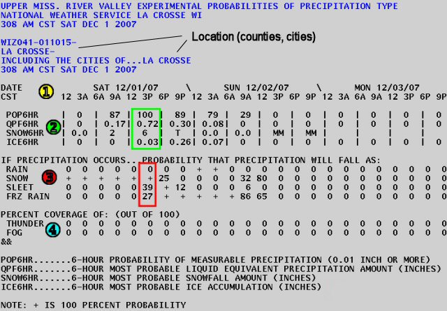
| 1 | The date and time (local) of the forecast, in 3 hour increments. In the example above, the forecast was made at 308 am on December 1, 2007. The forecast times ran from 12 am on Dec 1st through 9 pm on Dec 3rd. |
| 2 | The explanation for these 4 rows can be found at the bottom of the table and represents the "most probable" amounts of liquid, freezing, and frozen precipitation for 6 hour periods. In the example highlighted by the green box, there is a 100% chance of measurable precipitation, 0.72 inches of liquid equivalent precipitation, 6 inches of snow, and 0.03 inches of ice (from 12 pm to 6 pm on Dec 1). Again, these are most probable amounts and should be used as a guide, not a definitive amount. |
| 3 | If precipitation occurs, this section lists the percentages for each precipitation type. Note that the percentages do not have to add up to 100%. A 100% probability of both snow and rain in a forecast would indicate that both precipitation types are equally likely. In the example highlighted by the red box, there is 0% chance of rain, 100% chance of snow, 39% chance of sleet, and a 27% chance of freezing rain. If precipitation does fall, the forecaster believes it will fall as snow, but sleet could mix in, and to a lesser extent, freezing rain. |
| 4 | This section indicates the percent coverage (out of 100%) that thunder or fog could occur. This can also be interpreted as coverage. A 40% coverage of fog means 40% of the area will be covered by fog at that given time. |

