Four-County F1 Tornado
(Clay, Tallapoosa, Randolph, Chambers)
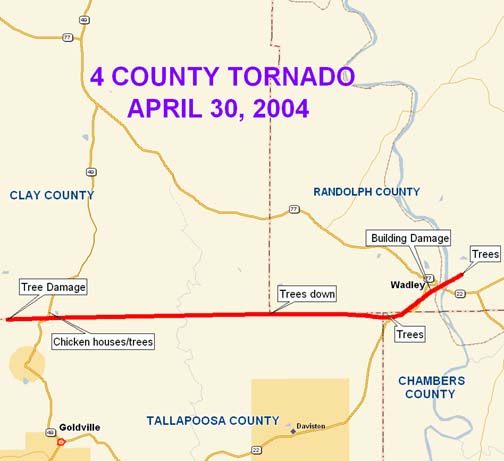
National Weather Service meteorologists surveyed tornado damage that started over extreme northern Tallapoosa County...about 2.2 miles northwest of Goldville. It appears the tornado began at 614 am. There was F0 damage, in the form of scattered tree damage, from Vine Road just south of the Clay County line, east to near Highway 49. The damage increased to F1 damage along Highway 49, especially to the southeast of the highway. There were several dozen trees snapped and uprooted, with many signs of convergence in the pattern of fallen trees. There were a few broken windows in two houses, and one house had its carport lifted up off most of its support columns. In the same area of concentrated damage, four chicken houses sustained significant roof damage, and the tin was blown down the tornado track for about 100 yards. The chicken houses were just north of the county line, in Clay County. The tornado damage path was about 200 yards wide at this point. This damage occurred around 618 am.
The tornado path continued to the east with more trees blown down along the Tallapoosa-Clay county line, including across Simpson Road and County Road 79. As it crossed County Road 79, around 627 am, the damage was along the Tallapoosa-Randolph county line. The damage path entered extreme northwest chambers county, around 630 am, along and north of Highway 22. At this point the tornado track ran parallel to Highway 22 all the way to Wadley, on a northeast track.
Three brick buildings were significantly damaged in downtown Wadley, about 100 yards north of the Highway 22/77 intersection, on the east side of Highway 77. The southern most building, built in 1925, sustained a fire several years ago and was condemned. The fire had gutted the two-story building, and only the four walls were left standing. There was no roof on this building and it was taller than the two adjacent and attached buildings. The tornado significantly damaged at least two of the walls, and the top of the building toppled over onto the adjacent buildings, causing more damage. Since the integrity of the building had already been compromised, it was determined the damage was consistent with F0/F1 wind speeds.
The tornado continued northeast across the Tallapoosa River and knocked down more trees near the intersection of County Road 33 and County Road 828, just south of Louina. The total length of the tornado was 15.9 miles.
Watches/Warnings:
Tornado Watch number 215 was in effect from 500 AM until 1200 PM CDT.
The following Severe Thunderstorm Warnings were in effect: Clay County from 539 AM until 630 am; Randolph County from 607 AM until 645 AM; Tallapoosa County from 608 AM until 715 AM; Chambers County from 624 AM until 730 AM.