National Weather Service United States Department of Commerce

Local Sounding Data

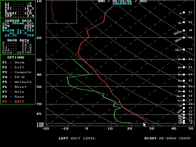
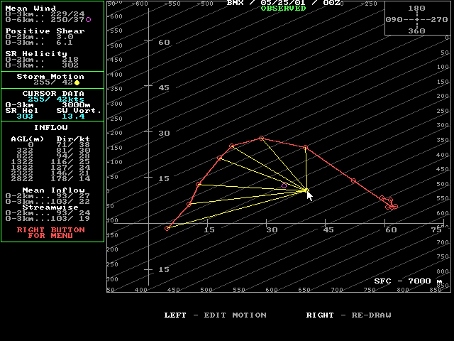
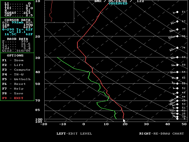
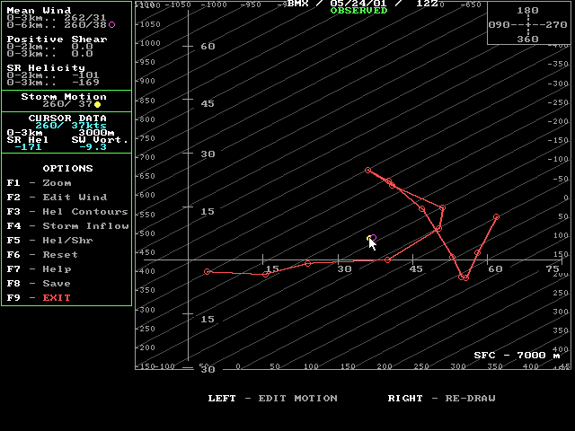
Shown below are the morning and evening soundings on May 24, 2001, at the Shelby County Airport, Alabama. There are four images. The Skew T diagram shows the temperature, moisture and wind profile through the atmosphere. The hodograph shows how the winds change with height. Soundings are also used to generate other parameters which are listed below.

The soundings from May 24, 2001, show that the atmosphere was relatively stable during the morning and became unstable through the day and into the evening. Most notable is the vertical profile of winds and how it changed through the day. Storm Relative Helicity and the shape of the hodograph significantly changed from morning to evening. The wind profile became more favorable through the afternoon for rotating storms.

Observed sounding at the Shelby County Airport on May 24, 2001, 7:00 AM CDT ( or 1200 UTC ).

  • CAPE = 0 J/Kg
  • Lifted Index = 1
  • K-Index = 31
  • Showalter Index = 0
  • Total Totals = 51
  • Sweat Index = 263
  • BRN = 0
  • BRN Shear = 113(m/s)2
  • Precipitable Water = 1.07 inches
  • Cap Strength = 3.2
  • Wet-Bulb Zero = 7800 feet
  • Mean Wind (0-6Km).. 260/ 37 kts
  • Pos Shear (0-2Km).. 0 (10-3 S-1)
  • Storm Motion....... 290/ 28 kts
  • Storm Relative Directional Shear (0-3km) = 96 degrees
  • Energy/Helicity Index = 0.00
  • Storm Relative Helicity (0-3Km) = -87 (m/s)2

Shelby County Airport Skew T on May 24, 2001, 1200 UTC or 7:00 AM CDT

Shelby County Airport hodograph on May 24, 2001, 1200 UTC or 7:00 AM CDT

Observed sounding at the Shelby County Airport on May 24, 2001 7:00 PM CDT ( or May 25, 2001 0000 UTC ).

  • CAPE = 571 J/Kg
  • Lifted Index = -2
  • K-Index = 32
  • Showalter Index = 1
  • Total Totals = 50
  • Sweat Index = 310
  • BRN = 5
  • BRN Shear = 110(m/s)2
  • Precipitable Water = 1.08 inches
  • Cap Strength = 1.8 C
  • Wet-Bulb Zero = 9900 feet
  • Mean Wind (0-6Km).. 250/ 36 kts
  • Pos Shear (0-2Km).. 3 (10-3 S-1)
  • Storm Motion....... 259/ 43 kts
  • Storm Relative Directional Shear (0-3km) = 114 degrees
  • Energy/Helicity Index = 0.87
  • Storm Relative Helicity (0-3Km) = 340 (m/s)2


Shelby County Airport Skew T on May 25, 2001, 0000 UTC or 7:00 PM CDT May 24, 2001

Shelby County Airport hodograph on May 25, 2001, 0000 UTC or 7:00 PM CDT May 24, 2001