Republican River Flood of May 30, 1935

This website is dedicated to preserving the history of the Republican River Flood of 1935.
Recently David Pearson, Senior Service Hydrologist at Omaha, Nebraska released a paper on the top five floods in Nebraska. The 1935 Republican River flood remains at the top of the list! If you would like to learn more about his research you can check out his paper here!
On May 30, 1935 in the middle of the Dust Bowl, one of the greatest droughts the Great Plains has seen, a historic flood swept through the Republican River, creating devastation along it's path. As stated on the historical marker at Orleans, Nebraska, "On May 30, 1935, torrential rains fell in eastern Colorado and southwestern Nebraska; by early morning of the 31st, the usually peaceful Republican River was running bluff-to-bluff along its upper reaches. When the waters subsided two days later, over 100 lives had been lost and many millions of dollars of damage had been done..." Thus begins the story about the flood.
"The entire Republican-Kansas River Valley is well provided with tributary streams, and numerous tributaries join the main river, both from the north and from the south. Many of these tributaries are comparatively short, with a total fall of 200 to 300 feet, so that storm run-off is delivered quickly from them to the main stream.
The Republican River flows through a valley which, throughout most of its course, has a width of 2 to 3 miles, with bordering uplands rising 100 to 200 feet above the valley floor. The main valley and those of its principle tributaries are bordered by a definite system of terraces." From Follansbee and Speigel, 1937 pg. 30.
History of the Republican River Basin
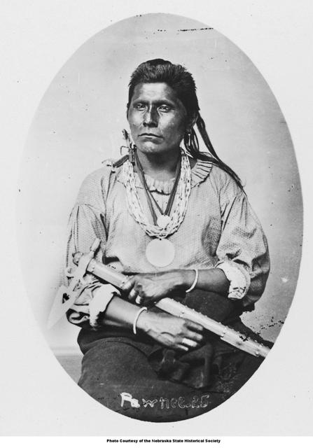
Before the homesteaders began farming and ranching in the Republican River Basin, the Native American tribe of the Republican Pawnee lived in the region. A photo of a Republican Pawnee courtesy of the Nebraska State Historical Society is shown below.
 |
"For the Republican River, as for many other western streams, there is the usual Indian tradition of a higher flood before the days of the white man. Engineers, in the course of their investigations of the flood of May and June of 1935, found three separate references to such flood. An old Indian in the vicinity of Benkelman made the statement that 40 years before he was born there was a great flood 2 feet higher than that of 1935. As he was about 70 years old, this would date the legendary flood as approximately 1826. A resident near Cambridge stated that when his father settled the Republican River bottoms would be flooded out, as he had seen, while a boy, the waters 'extending from bluff to bluff.' At Red Cloud several residents stated that one of Chief Red Cloud's relatives who lived nearby was authority for the statement that more than 100 years ago a flood covering the bottoms "from bluff to bluff" had occurred. These statements are consistent and apparently had partial historic confirmation. At the time of this earlier flood there were no white settlers in the Republican River Basin, and the only white travelers were fur traders on the way from St. Louis to the Rocky Mountains and points beyond. Search through the available writings of these travelers fails to reveal any reference to such a flood. It is therefore necessary to rely on inferential evidence from localities where whites had settled." From Follansbee and Spiegel, 1937, pg 50. |
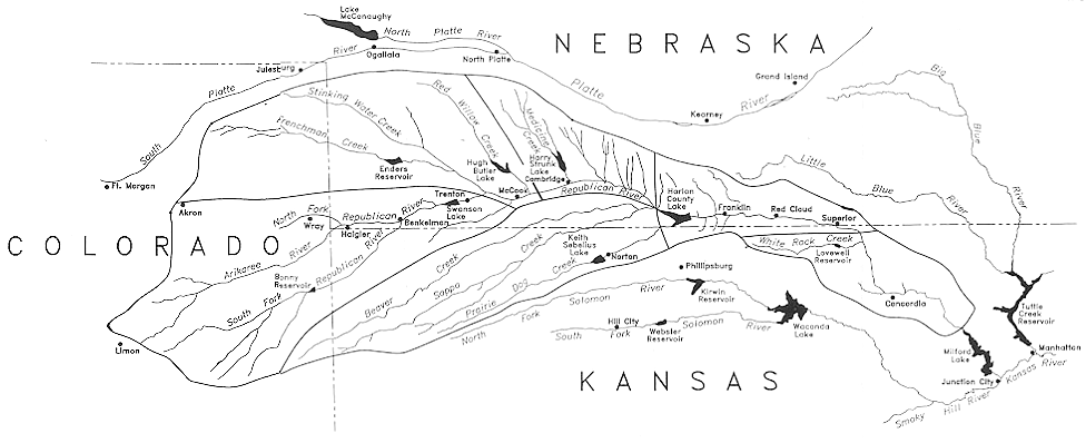
Below are maps of the Republican River Basin. The colors indicate sub-basins within the Republican River Basin. The first map is a map of towns in the basin while the second map shows the names of the rivers and tributaries. Click on each map to enlarge.


Below is a map of the river as it exists today:
 |


 Follow us on YouTube