National Weather Service United States Department of Commerce


Christian County tornadoes since 1950


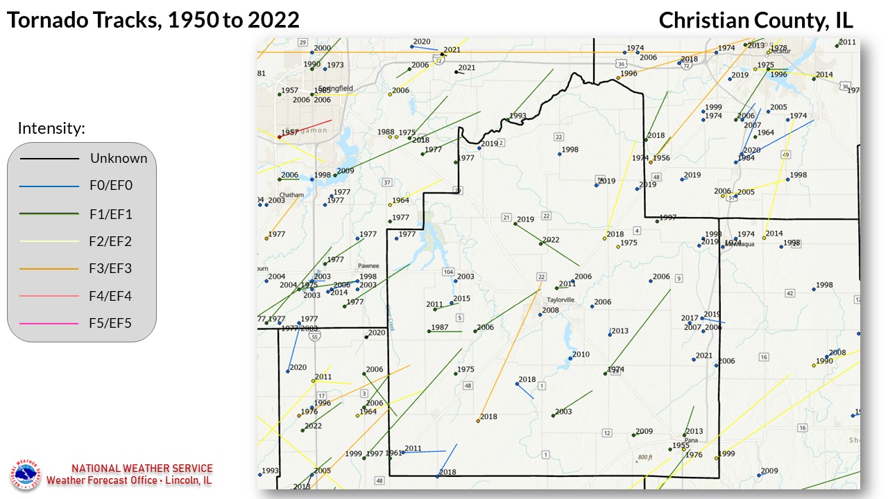
50 TORNADOES were reported in Christian County, Illinois between 01/01/1950 and 12/31/2022.

Click on Location or County to display Details.

Mag:
Dth:
Inj:
PrD:
CrD:
Magnitude
Deaths
Injuries
Property Damage
Crop Damage
Illinois
Location or County Date Time (CST) Mag Dth Inj PrD CrD
Pana 11/15/1955 04:45 PM F1 0 0 N/A 0
Harvel 09/30/1961 01:45 PM F1 0 0 25K N/A 
Morrisonville 04/02/1964 08:49 PM F2 0 0 25K 0
4 Stonington 04/03/1974 01:30 PM F3 0 0 N/A 0
Owaneco 04/03/1974 01:45 PM F1 0 0 250K 0
Palmer 05/11/1975 05:00 PM F1 0 2 3K 0
Assumption 07/08/1975 06:30 PM F2 0 0 0K 0
Pana 02/16/1976 03:45 PM F2 0 0 250K 0
Morrisonville 03/20/1976 12:12 PM F3 0 0 250K 0
10 Sangchris Lake 08/06/1977 03:55 PM F0 0 0 0K 0
11 Breckenridge 08/06/1977 04:00 PM F1 0 0 0K 0
12 Morrisonville 04/13/1987 09:30 AM F1 0 2 25K 0
13 Assumption 04/07/1998 05:14 PM F0 0 0 0 0
14 Mt Auburn 06/14/1998 06:52 PM F0 0 0 0 0
15 Morrisonville 06/01/1999 06:13 PM F1 0 0 750K 0
16 Kincaid 05/10/2003 07:08 AM F0 0 0 0 0
17 Owaneco 08/31/2003 03:14 PM F1 0 0 0 0
18 Morrisonville 04/02/2006 04:58 PM F0 0 0 0 0
19 Taylorville 04/02/2006 05:08 PM F1 0 1 0 0
20 Pana 04/02/2006 05:15 PM F1 0 0 0 0
21 Taylorville 04/02/2006 05:17 PM F0 0 0 0 0
22 Assumption 04/02/2006 05:20 PM F1 0 0 0 0
23 Taylorville 04/16/2006 01:53 PM F0 0 0 0 0
24 Assumption 04/16/2006 02:05 PM F0 0 0 0 0
25 Stonington 04/16/2006 02:07 PM F0 0 0 0 0
26 Morrisonville 05/24/2006 03:10 PM F0 0 0 0 0
27 Assumption 04/25/2007 01:40 PM EF0 0 0 0 0
28 Taylorville 05/30/2008 07:20 PM EF0 0 0 0 0
29 Rosamond 05/13/2009 11:04 PM EF1 0 0 50K 0
30 Owaneco 06/03/2010 12:06 PM EF0 0 0 0 0
31 Tovey 04/19/2011 05:17 PM EF1 0 0 90K 0
32 Morrisonville 04/19/2011 05:30 PM EF0 0 0 95K 0
33 Taylorville 04/19/2011 05:32 PM EF1 0 0 60K 0
34 Owaneco 05/09/2013 04:41 PM EF0 0 0 0 0
35 Pana 11/17/2013 12:15 PM EF1 0 0 300K 0
36 Pana 02/20/2014 04:09 PM EF1 0 0 500K 0
37 Tovey 04/09/2015 06:47 PM EF0 0 0 0 0
38 Assumption 05/23/2017 03:30 PM EF0 0 0 0 0
39 Palmer 05/15/2018 03:37 PM EF0 0 0 0 0
40 Harvel 12/01/2018 04:48 PM EF0 0 0 140K 0
41 Taylorville 12/01/2018 05:01 PM EF3 0 22 118.9M 0
42 Stonington 12/01/2018 05:34 PM EF2 0 0 3.3M 0
43 Stonington 05/29/2019 03:28 PM EF0 0 0 0 0
44 Roby 05/29/2019 03:30 PM EF0 0 0 0 0
45 Stonington 05/29/2019 03:35 PM EF0 0 0 0 0
46 Moweaqua 06/19/2019 05:40 PM EF0 0 0 0 0
47 Sharpsburg 08/12/2019 08:08 PM EF1 0 0 75K 630K
48 Assumption 08/12/2019 08:40 PM EF0 0 0 20K 0
49 Assumption 05/06/2021 01:11 PM EF0 0 0 25K 0
50 Sharpsburg 04/24/2022 04:49 PM EF1 0 0 N/A 0
TOTALS: 0 27 125.1M 630K


Details:

  1. 11/15/1955:  Demolished several farm buildings near Pana.
  2. 9/30/1961:  Destroyed several farm buildings near Harvel.
  3. 4/2/1964:  This tornado touched down in Montgomery County, 4 miles east-southeast of Farmersville.  It moved into Christian County, passing 2 miles northwest of Morrisonville.
  4. 4/3/1974:  This was part of the "Super Outbreak" of 148 tornadoes which affected the eastern half of the U.S. in less than 24 hours.   This particular tornado touched down north of Stonington, and moved into Macon County, passing along the west and north edge of Decatur.
  5. 4/3/1974:  This was part of the "Super Outbreak" of 148 tornadoes which affected the eastern half of the U.S. in less than 24 hours.  This tornado hit the north side of Owaneco, destroying a building and many farm sheds.
  6. 5/11/1975:  Touched down near Palmer.  Two injuries were reported in overturned trailers.
  7. 7/8/1975:  Touched down between Stonington and Assumption.
  8. 2/16/1976:  This tornado moved across Pana, destroying one home and damaging 40 others.
  9. 3/20/1976:  This tornado touched down near Farmersville, in northern Montgomery County, and moved into Christian County about 5 miles northwest of Morrisonville.  It was on the ground for 11 miles.
  10. 8/6/1977:  This was one of 18 tornadoes to affect southern Sangamon and northwest Christian Counties on this date.  This particular tornado originated south of Pawnee in Sangamon County, and moved into Christian County for 1.1 miles, affecting the Sangchris Lake area.
  11. 8/6/1977:  This was one of 18 tornadoes to affect southern Sangamon and northwest Christian Counties on this date. This tornado touched down near Breckenridge in southeast Sangamon County, then moved briefly into Christian County.  While roof damage occurred in Roby, this was likely due to an associated downburst of wind.
  12. 4/13/1987:  Touched down 2 miles west and 6 miles north of Morrisonville.  It moved across 5 farms along the 3 mile track.
  13. 4/7/1998:  Brief touchdown in a field, 7.5 miles north of Assumption.
  14. 6/14/1998:  Brief touchdown in a field, 2 miles south of Mount Auburn.
  15. 6/1/1999:  Originally touched down in Montgomery County, and entered Christian County 4.4 miles southwest of Morrisonville.  It was on the ground for 11 miles in Christian County, before lifting 4 miles north of Palmer.  Many outbuildings were severely damaged or destroyed.
  16. 5/10/2003:  Brief touchdown 1 mile west of Kincaid, destroying a grain silo and several trees.
  17. 8/31/2003:  Touched down 6 miles southwest of Owaneco, and was on the ground for 5 miles, lifting 3 miles south-southwest of Owaneco.
  18. 4/2/2006:  Touched down in Montgomery County, and briefly moved into Christian county 5 miles northwest of Morrisonville before dissipating.
  19. 4/2/2006:  Touched down 6 miles west-southwest of Taylorville before moving into town.
  20. 4/2/2006: Originally touched down in far southwest Shelby County, before entering Christian County and hitting Pana.
  21. 4/2/2006:  Brief touchdown in a field, 4 miles northeast of Taylorville.
  22. 4/2/2006:  Took a 1-mile path through Assumption.
  23. 4/16/2006:  Brief touchdown in a field, 5 miles east of Taylorville.
  24. 4/16/2006:  Brief touchdown in a field, 3 miles south-southeast of Assumption.
  25. 4/16/2006:  Brief touchdown in a field, 5 miles southeast of Stonington.
  26. 5/24/2006:  Touched down in Montgomery County, and entered Christian County 5 miles west-northwest of Morrisonville.  It caused significant roof damage at a farm.
  27. 4/25/2007:  Brief touchdown in a field 4 miles west of Assumption.
  28. 5/30/2008:  Brief touchdown in a file 1 mile south of Taylorville.
  29. 5/13/2009:  This tornado touched down 4 miles west of Pana, and moved northeast for 1 mile.  A pole barn was severely damaged, and some minor roof damage occurred to a house.
  30. 6/3/2010:  Brief touchdown 3 miles northwest of Owaneco.
  31. 4/19/2011:  Touched down 4 miles southwest of Kincaid, and was on the ground for 2 miles.  Destroyed several grain bins and a large farm storage building.
  32. 4/19/2011:  Touched down 2 miles northeast of Harvel, and lifted 3 miles southeast of Morrisonville.  It destroyed a small barn and damaged a hog pen and large metal farm building.
  33. 4/19/2011:  Touched down 2 miles northeast of Taylorville, knocking over 8 empty railroad cars.
  34. 5/9/2011:  Touched down in a field 2.4 miles north of Owaneco, and moved north for about half a mile, causing no damage.
  35. 11/17/2013:  This was part of a 10 tornado outbreak in central Illinois.  This tornado touched down on the north edge of Pana.  Click here for more details.
  36. 2/20/2014:  This tornado originally touched down in Montgomery County, then clipped Shelby County before passing just east of Pana and back into Shelby County.  Click here for more details.
  37. 4/9/2015:  Brief touchdown in a field 2.6 miles south-southeast of Tovey.
  38. 5/23/2017:  A brief landspout tornado occurred in an open field. 
  39. 5/15/2018:  Touched down in an open field 3.7 miles east of Palmer, and traveled southeast for 1.8 miles. No damage was reported.
  40. 12/1/2018:  This was part of a historic late-season tornado outbreak in central Illinois. This tornado moved in from Montgomery County before lifting 2.9 miles south-southeast of Morrisonville. Click here for more details. 
  41. 12/1/2018:  This strong tornado touched down 3.2 miles east-southeast of Morrisonville, tracking northeast and causing severe damage in Taylorville.  Click here for more details.
  42. 12/1/2018:  Touched down on the southwest edge of Stonington, and was on the ground for 8.4 miles. Click here for more details.
  43. 5/19/2019:  Landspout tornado touched down 3.8 miles north-northwest of Stonington, causing no damage.
  44. 5/19/2019:  Landspout tornado touched down 1 mile northeast of Roby, causing no damage.
  45. 5/19/2019:  Landspout tornado touched down 4.1 miles northeast of Stonington, causing no damage. 
  46. 6/19/2019:  Brief touchdown 2 miles west of Moweaqua, causing some crop damage.
  47. 8/12/2019:  This tornado touched down 2.7 miles east-southeast of Edinburg, and was on the ground for 6.2 miles. Click here for more details. 
  48. 8/12/2019:  Touched down 1 mile north of Assumption before crossing into Shelby County.  Click here for more details. 
  49. 5/6/2021:  Touched down 2.6 miles southwest of Assumption. It damaged several trees, which punched a hole in the roof of a building.
  50. 4/24/2022:  Touched down 3 miles east-northeast of Sharpsburg, demolishing a 60x120 foot shed.