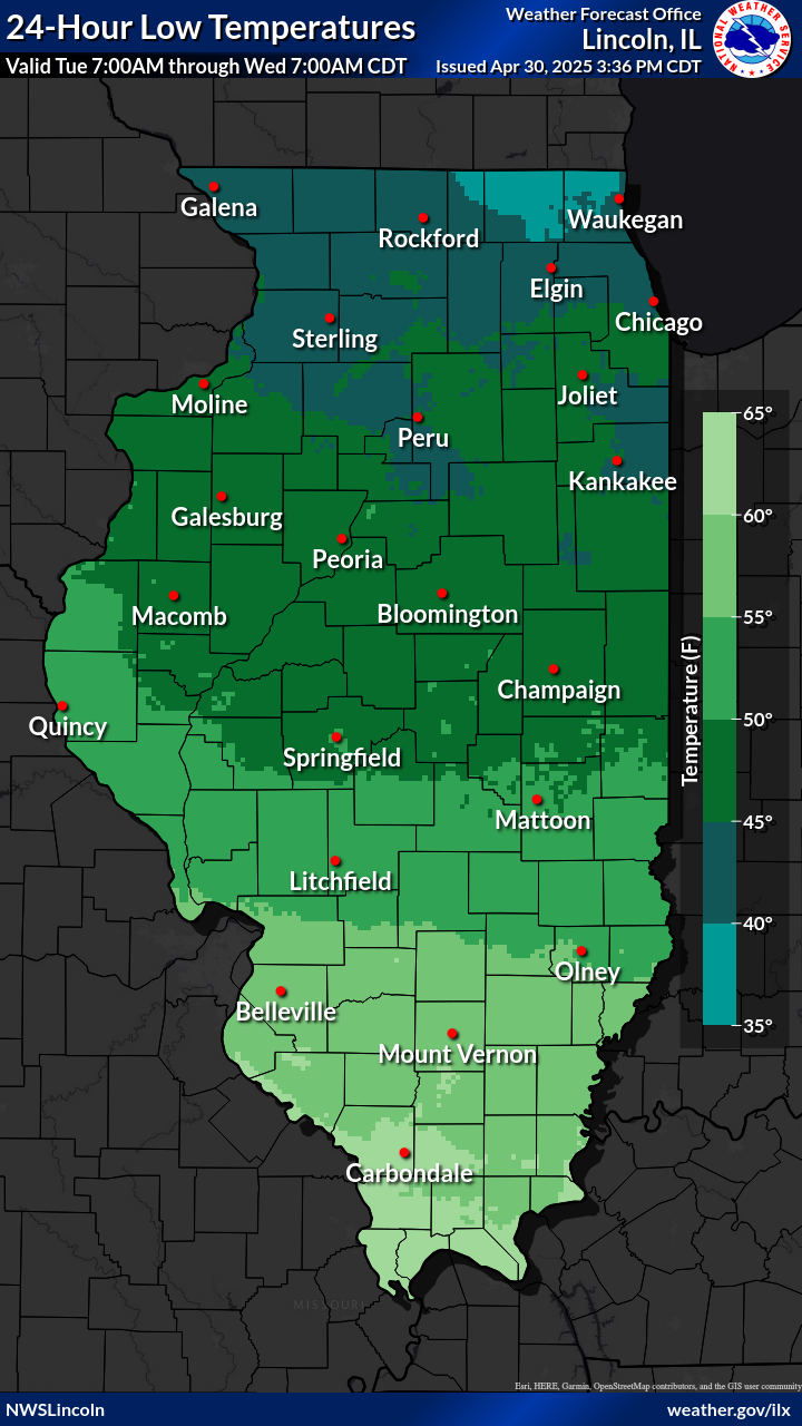
| Preliminary data based on the Real-Time Mesoscale Analysis (RTMA) 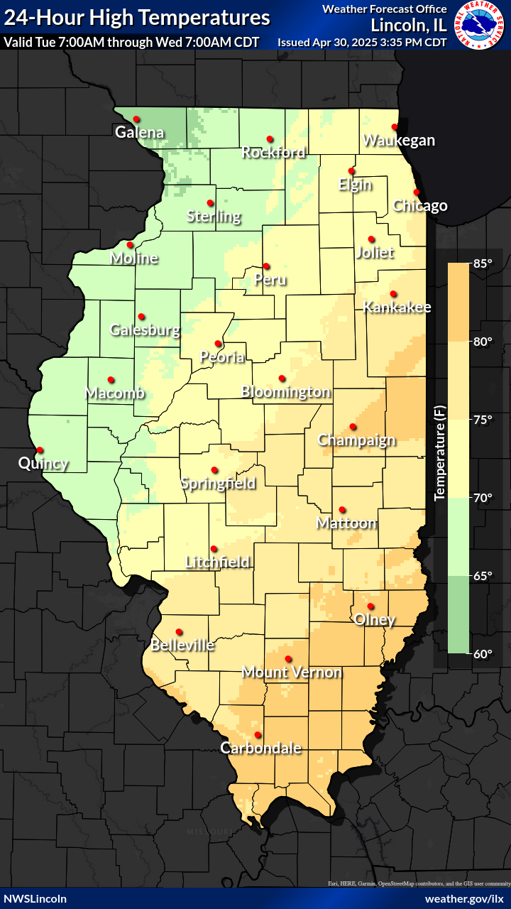 |
Observed data reported by NWS, FAA and cooperative weather observers
925 AM CST Sat Nov 29 2025

Automated and Cooperative Observer Reports
Values represent high and low temperatures
for the 24-hour period ending around 7 am.

          Location               High   Low

...NORTHERN ILLINOIS...
Aurora/Sugar Grove Arpt           31     17
Barrington                        31     19
Batavia                           32     19
Chicago Midway Arpt               32     21
Chicago Midway COOP               32     21
Chicago O'Hare Arpt               32     21
Coal City 4NNW                    35     19
DeKalb Municipal Arpt             30     18
DeKalb Northern IL Univ           31     17
Elgin                             32     19
Elizabeth                         33     17
Freeport                          33     19
Joliet Rgl Arpt                   34     21
Kewanee                           32     21
Lansing Municipal Arpt            32     20
Moline/Quad Cities Arpt           33     19
Morris                            32     20
Morris Municipal Arpt             32     18
New Boston L&D 17                 39     21
Ottawa                            35     19
Park Forest                       33     20
Peru/IL Valley Rgl Arpt           33     20
Romeoville/NWS Chicago            31     19
Schaumburg Rgl Arpt               32     21
Sterling/Rock Falls Arpt          33     17
Stockton                          31     17
Waukegan Rgl Arpt                 31     17
West Chicago/DuPage Arpt          31     19
Wheeling/Chicago Exec Arpt        32     21

...CENTRAL ILLINOIS...
Aledo                             38     17
Avon                              32     20
Bentley                           36     24
Bloomington/Cntrl IL Rgl Arpt     33     17
Champaign 3S                      35     22
Champaign/Willard Arpt            33     15
Coles County Arpt                 33     18
Decatur Arpt                      33     20
Edgar County Arpt                 33     19
Galesburg Municipal Arpt          32     15
Galesburg Water Plant             30     15
Jacksonville 2                    34     17
Jacksonville Municipal Arpt       32     15
Lacon/Marshall Co Arpt            33     16
Lincoln NWS                       32     19
Macomb Municipal Arpt             33     16
Minonk                            37     15
Normal 4NE                        30     18
Ogden                             33     19
Pana                              34     22
Paris                             33     19
Peoria Intl Arpt                  33     19
Pittsfield/Penstone Arpt          25     20
Pontiac Municipal Arpt            32     18
Quincy Rgl Arpt                   31     17
Rantoul Aviation Center           33     17
Shelbyville Dam                   33     21
Sidell 4N                         38     21
Springfield/Capital Arpt          34     17
Taylorville Municipal Arpt        32     19
Tuscola                           33     19
Windsor                           33     20

...SOUTHERN ILLINOIS...
Alton/Mel Price L&D               36     21
Anna                              40     24
Cahokia/Parks Arpt                37     19
Carbondale/Southern IL Arpt       39     23
Crawford County Arpt              35     21
Effingham Co Arpt                 35     20
Fairfield Municipal Arpt          37     23
Grand Chain Dam                   41     32
Harrisburg Arpt                   39     23
Kaskaskia L&D                     37     23
Lawrenceville/Vincennes Arpt      36     22
Millstadt                         35     18
Mt Carmel Municipal Arpt          37     22
Mt Vernon                         38     19
Olney/Noble Arpt                  36     23
Salem                             36     22
Salem/Leckrone Arpt               36     23
Smithland Dam                     40     27
Sparta Community Arpt             37     24

$$
|
|
Preliminary data based on the Real-Time Mesoscale Analysis
|
Observed data from NWS, FAA, and cooperative weather observers
925 AM CST Sat Nov 29 2025

Automated and Cooperative Observer Reports
Values represent high and low temperatures
for the 24-hour period ending around 7 am.

          Location               High   Low

...NORTHERN ILLINOIS...
Aurora/Sugar Grove Arpt           31     17
Barrington                        31     19
Batavia                           32     19
Chicago Midway Arpt               32     21
Chicago Midway COOP               32     21
Chicago O'Hare Arpt               32     21
Coal City 4NNW                    35     19
DeKalb Municipal Arpt             30     18
DeKalb Northern IL Univ           31     17
Elgin                             32     19
Elizabeth                         33     17
Freeport                          33     19
Joliet Rgl Arpt                   34     21
Kewanee                           32     21
Lansing Municipal Arpt            32     20
Moline/Quad Cities Arpt           33     19
Morris                            32     20
Morris Municipal Arpt             32     18
New Boston L&D 17                 39     21
Ottawa                            35     19
Park Forest                       33     20
Peru/IL Valley Rgl Arpt           33     20
Romeoville/NWS Chicago            31     19
Schaumburg Rgl Arpt               32     21
Sterling/Rock Falls Arpt          33     17
Stockton                          31     17
Waukegan Rgl Arpt                 31     17
West Chicago/DuPage Arpt          31     19
Wheeling/Chicago Exec Arpt        32     21

...CENTRAL ILLINOIS...
Aledo                             38     17
Avon                              32     20
Bentley                           36     24
Bloomington/Cntrl IL Rgl Arpt     33     17
Champaign 3S                      35     22
Champaign/Willard Arpt            33     15
Coles County Arpt                 33     18
Decatur Arpt                      33     20
Edgar County Arpt                 33     19
Galesburg Municipal Arpt          32     15
Galesburg Water Plant             30     15
Jacksonville 2                    34     17
Jacksonville Municipal Arpt       32     15
Lacon/Marshall Co Arpt            33     16
Lincoln NWS                       32     19
Macomb Municipal Arpt             33     16
Minonk                            37     15
Normal 4NE                        30     18
Ogden                             33     19
Pana                              34     22
Paris                             33     19
Peoria Intl Arpt                  33     19
Pittsfield/Penstone Arpt          25     20
Pontiac Municipal Arpt            32     18
Quincy Rgl Arpt                   31     17
Rantoul Aviation Center           33     17
Shelbyville Dam                   33     21
Sidell 4N                         38     21
Springfield/Capital Arpt          34     17
Taylorville Municipal Arpt        32     19
Tuscola                           33     19
Windsor                           33     20

...SOUTHERN ILLINOIS...
Alton/Mel Price L&D               36     21
Anna                              40     24
Cahokia/Parks Arpt                37     19
Carbondale/Southern IL Arpt       39     23
Crawford County Arpt              35     21
Effingham Co Arpt                 35     20
Fairfield Municipal Arpt          37     23
Grand Chain Dam                   41     32
Harrisburg Arpt                   39     23
Kaskaskia L&D                     37     23
Lawrenceville/Vincennes Arpt      36     22
Millstadt                         35     18
Mt Carmel Municipal Arpt          37     22
Mt Vernon                         38     19
Olney/Noble Arpt                  36     23
Salem                             36     22
Salem/Leckrone Arpt               36     23
Smithland Dam                     40     27
Sparta Community Arpt             37     24

$$
|
|
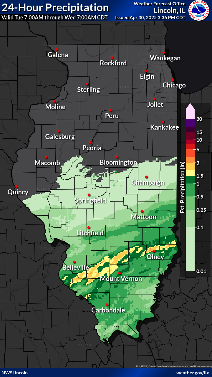
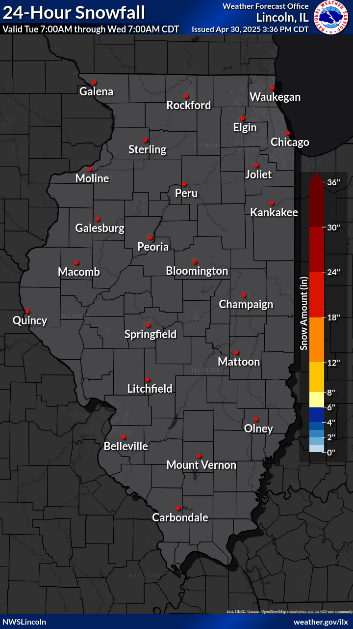
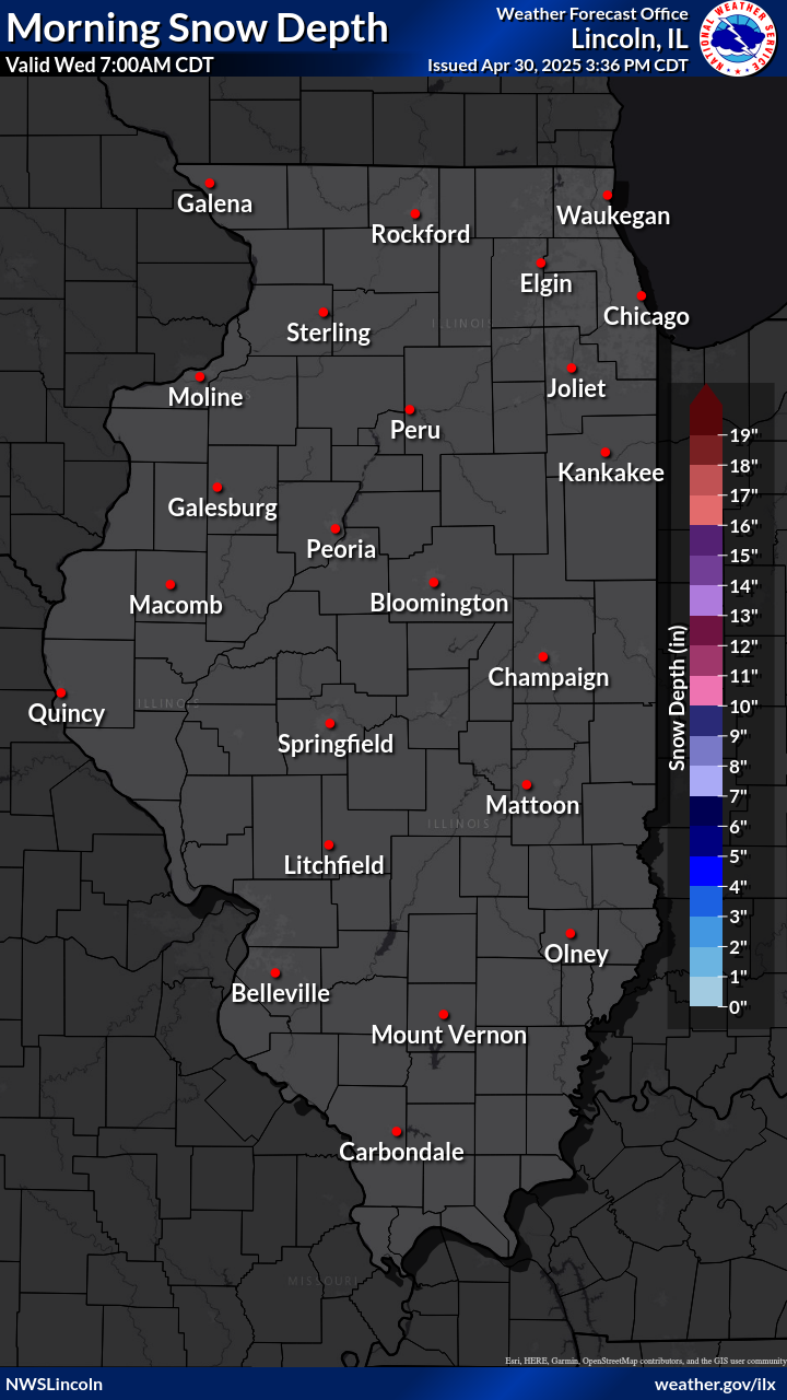
Preliminary data based on the Real-Time Mesoscale Analysis
CoCoRaHS Observations: |
Observations from NWS, FAA and cooperative weather observers
920 AM CST Sat Nov 29 2025

Automated and Cooperative Observer Reports
Values represent precipitation and snowfall
for the 24-hour period ending around 7 am.

          Location               Pcpn   Snow   Depth

...NORTHERN ILLINOIS...
Aurora/Sugar Grove Arpt          0.02
Barrington                       0.14    1.3     1
Batavia                          0.06    0.5     1
Bourbonnais                      0.14    0.9     1
Chatsworth                               3.0     3
Chicago Midway Arpt              0.00
Chicago O'Hare Arpt              0.03            1
Coal City 4NNW                   0.10    1.3     1
DeKalb Northern IL Univ          0.08    1.0     1
Elgin                            0.07    1.0     1
Elgin                            0.09    1.5     2
Elizabeth                        0.19    3.5     4
Freeport                         0.16    1.5     2
Genoa                            0.10    1.5     1
Hebron                           0.07    0.9     1
Joliet 2N                        0.03    0.5     1
Kewanee                          0.38    5.0     5
Lake Zurich                      0.08    0.7     1
Mendota                          0.08    0.8     1
Moline/Quad Cities Arpt          0.31
Morris                           0.15    2.0     2
New Boston L&D 17                0.00
Ottawa                           0.25    2.5     3
Park Forest                      0.01     T      T
Peotone                          0.11    1.2     1
Romeoville/NWS Chicago           0.01    0.2     T
Steward                          0.08    0.9     1
Stockton                         0.27    3.3     3
Streator                                 5.0
Waukegan Rgl Arpt                0.00
West Chicago/DuPage Arpt         0.02
Westmont                         0.08    0.3     0
Wheeling/Chicago Exec Arpt       0.01

...CENTRAL ILLINOIS...
Aledo                            0.04    2.6     3
Avon                             0.22    2.3     2
Bentley                          0.27    4.0     4
Bloomington/Cntrl IL Rgl Arpt    0.01
Buffalo                          0.10    1.5     2
Champaign 3S                     0.04    0.8     1
Champaign/Willard Arpt           0.00
Cisco                            0.06    0.7     1
Coles County Arpt                0.00
Decatur Arpt                     0.00
Galesburg Water Plant            0.01    0.5
Havana                                   3.5
Jacksonville 2                   0.40    6.0     6
Lake Springfield                 0.00
Lincoln NWS                      0.11    0.9     1
Lovington                          T      T      T
Mattoon                                  1.1     1
Minonk                                   2.8     3
Morton                           0.16    1.5     2
Mount Pulaski                    0.02    0.4     T
Moweaqua 2S                      0.00
Normal 4NE                       0.07    1.0     1
Ogden                            0.00    0.0     0
Paris                            0.00    0.0     0
Peoria 5NW                       0.09    1.5     2
Peoria Intl Arpt                 0.14
Quincy Rgl Arpt                  0.16
Rantoul                                          0
Roanoke                          0.17    2.0     2
Shelbyville Dam                    T      T      0
Sidell 4N                          T     0.2     T
Springfield/Capital Arpt         0.13
Tuscola                          0.02    0.5     T
Windsor                            T      T      T

...SOUTHERN ILLINOIS...
Alton/Mel Price L&D              0.02
Anna                             0.00
Cahokia/Parks Arpt               0.08
Carbondale/Southern IL Arpt      0.00
Centralia                        0.00
Edwardsville 2 W                 0.53    6.0     7
Grand Chain Dam                  0.00
Highland                         0.10    1.7     2
Hutsonville                      0.00    0.0     0
Kaskaskia L&D                    0.00    0.0     0
Lawrenceville/Vincennes Arpt     0.00
Millstadt                        0.03    4.4     4
Mt Vernon                        0.00
Salem                            0.00    0.0     0
Smithland Dam                    0.00    0.0     0

$$
|
| Preliminary data based on analysis from the NWS National Operational Hydrologic Remote Sensing Center (NOHRSC)
CoCoRaHS Observations: |
Observations from NWS, FAA and cooperative weather observers
920 AM CST Sat Nov 29 2025

Automated and Cooperative Observer Reports
Values represent precipitation and snowfall
for the 24-hour period ending around 7 am.

          Location               Pcpn   Snow   Depth

...NORTHERN ILLINOIS...
Aurora/Sugar Grove Arpt          0.02
Barrington                       0.14    1.3     1
Batavia                          0.06    0.5     1
Bourbonnais                      0.14    0.9     1
Chatsworth                               3.0     3
Chicago Midway Arpt              0.00
Chicago O'Hare Arpt              0.03            1
Coal City 4NNW                   0.10    1.3     1
DeKalb Northern IL Univ          0.08    1.0     1
Elgin                            0.07    1.0     1
Elgin                            0.09    1.5     2
Elizabeth                        0.19    3.5     4
Freeport                         0.16    1.5     2
Genoa                            0.10    1.5     1
Hebron                           0.07    0.9     1
Joliet 2N                        0.03    0.5     1
Kewanee                          0.38    5.0     5
Lake Zurich                      0.08    0.7     1
Mendota                          0.08    0.8     1
Moline/Quad Cities Arpt          0.31
Morris                           0.15    2.0     2
New Boston L&D 17                0.00
Ottawa                           0.25    2.5     3
Park Forest                      0.01     T      T
Peotone                          0.11    1.2     1
Romeoville/NWS Chicago           0.01    0.2     T
Steward                          0.08    0.9     1
Stockton                         0.27    3.3     3
Streator                                 5.0
Waukegan Rgl Arpt                0.00
West Chicago/DuPage Arpt         0.02
Westmont                         0.08    0.3     0
Wheeling/Chicago Exec Arpt       0.01

...CENTRAL ILLINOIS...
Aledo                            0.04    2.6     3
Avon                             0.22    2.3     2
Bentley                          0.27    4.0     4
Bloomington/Cntrl IL Rgl Arpt    0.01
Buffalo                          0.10    1.5     2
Champaign 3S                     0.04    0.8     1
Champaign/Willard Arpt           0.00
Cisco                            0.06    0.7     1
Coles County Arpt                0.00
Decatur Arpt                     0.00
Galesburg Water Plant            0.01    0.5
Havana                                   3.5
Jacksonville 2                   0.40    6.0     6
Lake Springfield                 0.00
Lincoln NWS                      0.11    0.9     1
Lovington                          T      T      T
Mattoon                                  1.1     1
Minonk                                   2.8     3
Morton                           0.16    1.5     2
Mount Pulaski                    0.02    0.4     T
Moweaqua 2S                      0.00
Normal 4NE                       0.07    1.0     1
Ogden                            0.00    0.0     0
Paris                            0.00    0.0     0
Peoria 5NW                       0.09    1.5     2
Peoria Intl Arpt                 0.14
Quincy Rgl Arpt                  0.16
Rantoul                                          0
Roanoke                          0.17    2.0     2
Shelbyville Dam                    T      T      0
Sidell 4N                          T     0.2     T
Springfield/Capital Arpt         0.13
Tuscola                          0.02    0.5     T
Windsor                            T      T      T

...SOUTHERN ILLINOIS...
Alton/Mel Price L&D              0.02
Anna                             0.00
Cahokia/Parks Arpt               0.08
Carbondale/Southern IL Arpt      0.00
Centralia                        0.00
Edwardsville 2 W                 0.53    6.0     7
Grand Chain Dam                  0.00
Highland                         0.10    1.7     2
Hutsonville                      0.00    0.0     0
Kaskaskia L&D                    0.00    0.0     0
Lawrenceville/Vincennes Arpt     0.00
Millstadt                        0.03    4.4     4
Mt Vernon                        0.00
Salem                            0.00    0.0     0
Smithland Dam                    0.00    0.0     0

$$
|
Map Archive:
A 365 day archive of these maps is available. Make your selections from the menu boxes below.
Tabular observations: