June 9-12, 2018
A persistent frontal boundary provided the focusing mechanism for several rounds of thunderstorms across central and southeast Illinois from the early morning of Sunday, June 10th through the morning of Tuesday, June 12th. The most significant severe weather occurred Sunday afternoon when a line of thunderstorms spawned two EF-0 tornadoes on the southwest side of Champaign and created scattered wind damage from McLean County southeastward to Vermilion and Edgar counties. These storms dropped southeastward, but then tended to re-develop on the back side of the departing complex...creating heavy rain and flash flooding along and south of I-70 Sunday evening. Additional thunderstorms developed along the boundary later Sunday night into Monday morning, then again Monday afternoon and night. Copious amounts of rain fell during this time...with areas from Taylorville southeastward to Mattoon and Robinson picking up 6 to 8 inches!
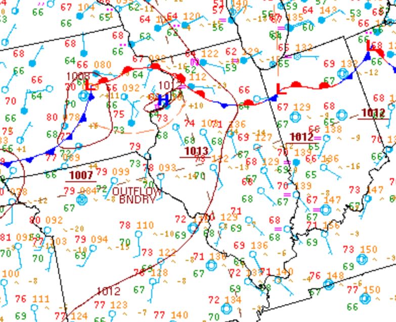
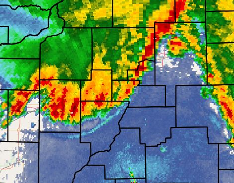
Surface analysis from the early morning of June 10th showed low pressure over east-central Iowa, with a nearly stationary frontal boundary extending eastward along the I-80 corridor. The airmass to the south of the front was very warm and humid...characterized by dewpoints in the upper 60s to around 70 degrees. As a low-level jet interacted with the approaching low, a large cluster of thunderstorms developed across northeast Iowa, southeast Minnesota, and southwest Wisconsin during the evening of June 9th...then began accelerating southeastward toward the more unstable air across central Illinois after midnight. Due to nocturnal stabilization of the boundary layer overnight, much of the wind energy with these storms remained aloft: however, widely scattered wind damage reports were received across the Illinois River Valley as a gust front raced out ahead of the storms. (Note the thin blue line across central Peoria County into far northern Fulton County on the radar picture below).
SURFACE WEATHER MAP 1AM CDT JUNE 10
RADAR IMAGERY 2:22AM CDT JUNE 10
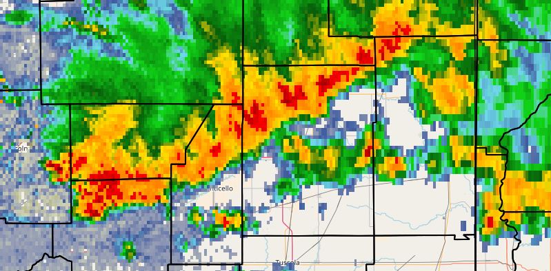
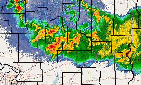
This first round of convection exited into Indiana during the morning of Sunday, June 10th: however, it left behind an outflow boundary that would serve as a renewed focus for additional storms during the afternoon. As the airmass destabilized, storms began to form along and just north of the primary frontal boundary between Peoria and Bloomington toward midday. These storms eventually congealed into a linear structure with a few embedded bowing segments as they tracked southeastward down the I-74 corridor. The surface map below shows that the front had dropped southward to a Quincy to Robinson line during the afternoon. South of the front, temperatures had soared into the lower to middle 90s...while to the north, readings were hovering in the upper 60s and lower 70s. Note the radar imagery from 2:15PM CDT, showing a line of strong to severe thunderstorms extending from northwest Vermilion County to northern Macon County. This line produced 60-70mph gusts and occasional wind damage from near Bloomington-Normal southeastward to Danville and Paris. In addition, two brief EF-0 tornadoes developed along the leading edge of the storms on the southwest side of Champaign....causing roof damage to a few homes and downing numerous trees and powerlines.
SURFACE WEATHER MAP 4PM CDT JUNE 10

RADAR IMAGERY 2:15PM CDT JUNE 10
These storms eventually settled into southeast Illinois by late Sunday afternoon: however, due to a very warm/moist inflow from the southwest, they tended to continuously regenerate on their rear flank. Due to the backbuilding of cells and the resulting prolonged rainfall, flash flooding occurred along and south of I-70 Sunday evening. Additional convection developed further west along the stationary frontal boundary overnight as the low-level jet strengthened and allowed warm/moist air to override the boundary. The radar imagery below from 3:12AM CDT June 11 shows widespread showers and thunderstorms stretching from just south of Springfield E/SE to Robinson.
RADAR IMAGERY 3:12AM CDT JUNE 11
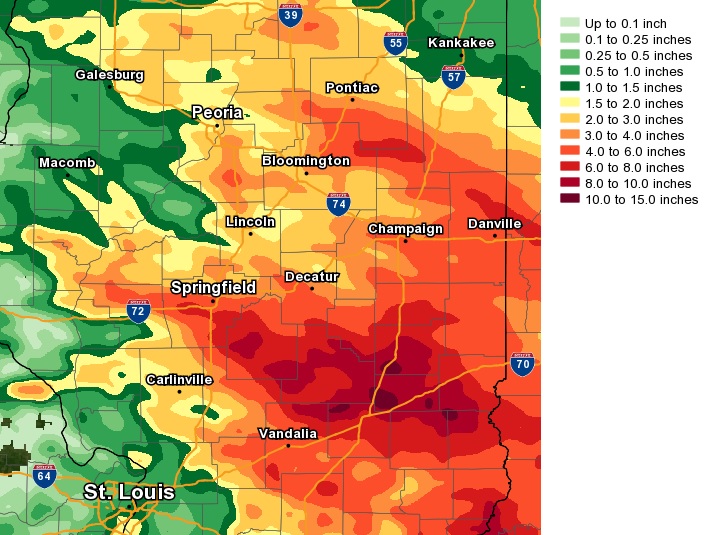
The unsettled weather continued on Monday, June 11th as several waves of convection developed along and just north of the persistent frontal boundary. The rain eventually shifted eastward out of the area by midday June 12th. Rainfall from this prolonged event was impressive...with as much as 6 to 8 inches being recorded from Christian County E/SE to Clark County. Doppler radar estimates a few locations across far southern Coles County into southeast Shelby and Cumberland counties could have picked up as much as 10 inches: however, no official measurement was received in these areas to corroborate this. Due to the excessive rainfall, widespread flash flooding caused road closures across portions of Christian, Shelby, Effingham, Cumberland, and Clay counties. Below is the June 9-12 rainfall map from this event.
JUNE 9-12 RAINFALL MAP