November 17-18, 2015 Tornadoes
Event Summary
A potent upper level storm system developed and intensified across the Plains on Monday into Tuesday (Nov 16-17) and set the stage for high winds and some severe weather across the ArkLaMiss region. As the storm system tracked across the Plains, it brought fairly rare severe weather to Texas, Oklahoma and Kansas for November late in the evening and overnight hours of the 16th and 17th. Several strong, long track tornadoes occurred across the Plains, which typically doesn’t see events like that except during the spring months. Ahead of the storm system, anomalous moisture for this time of year streamed into the ArkLaMiss region thanks to strong southerly winds. These winds gusted to around 40mph, causing some trees to fall ahead of any thunderstorms on the 17th.
By late afternoon on the 17th, a squall line began to take shape across Louisiana and Arkansas. This line was slow to develop severe weather but some damaging wind gusts occurred across Ashley and Chicot counties as well as portions of the Delta region. Plenty of wind energy was in place, which eventually was tapped into by the time the squall line reached the Interstate 55 corridor. The intensity of the thunderstorms increased as well as additional areas of rotation. As the line tracked across central and east Mississippi through the late evening and early morning hours, 12 tornadoes developed. These tornadoes developed as small areas of rotation occurred on the northern end of bowing segments within the squall line. Many of these tornadoes were short-lived and all were rated EF-0 and EF-1. The squall line cleared the region before dawn on the 18th.
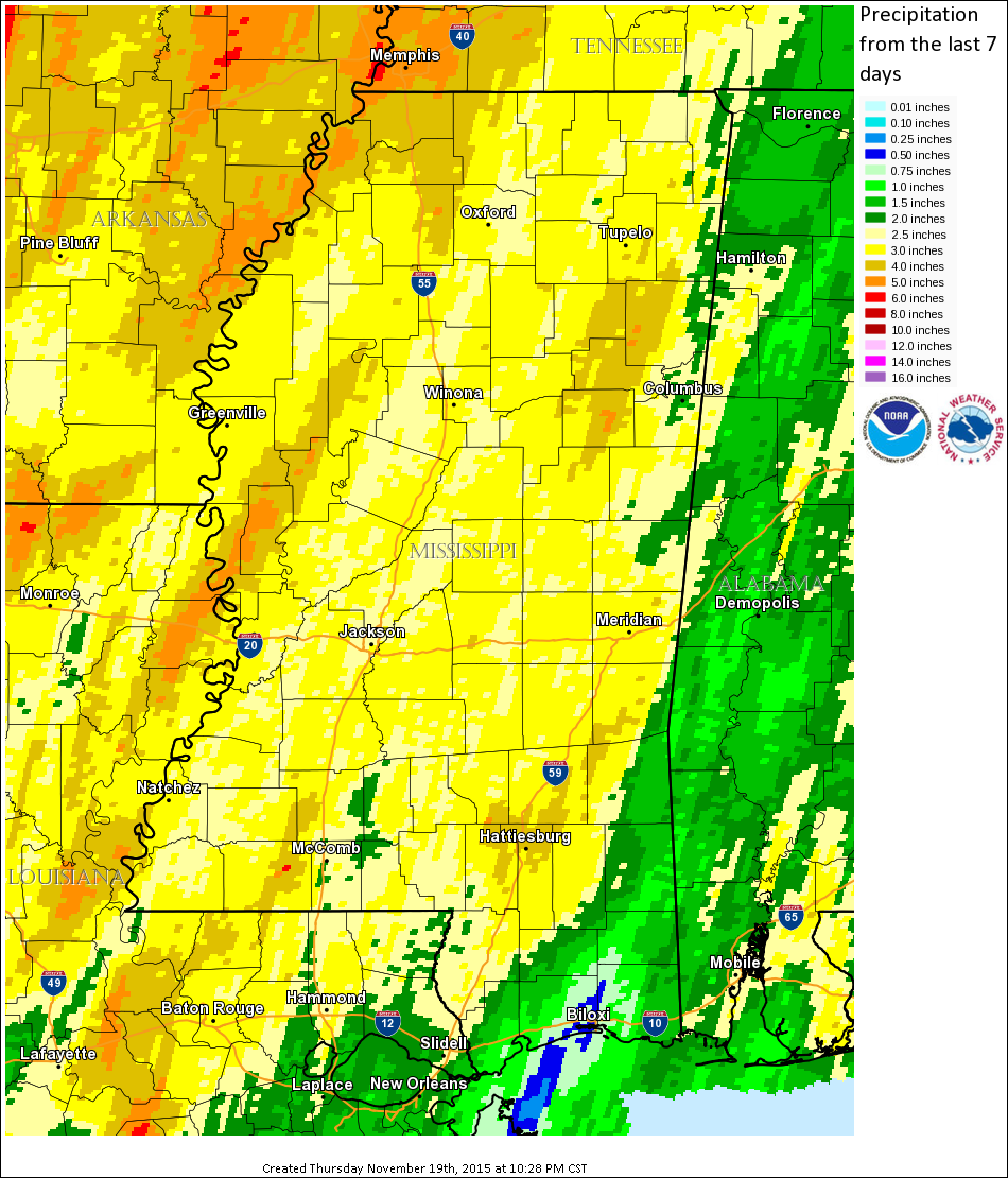
In addition to the damaging winds and tornadoes, heavy rain fell across the region. Many locations received two to five inches of rain, which resulted in some flash flooding. East and southeast Mississippi saw the least amount of rain, but still measured around one to two inches.
Tornado Track Map
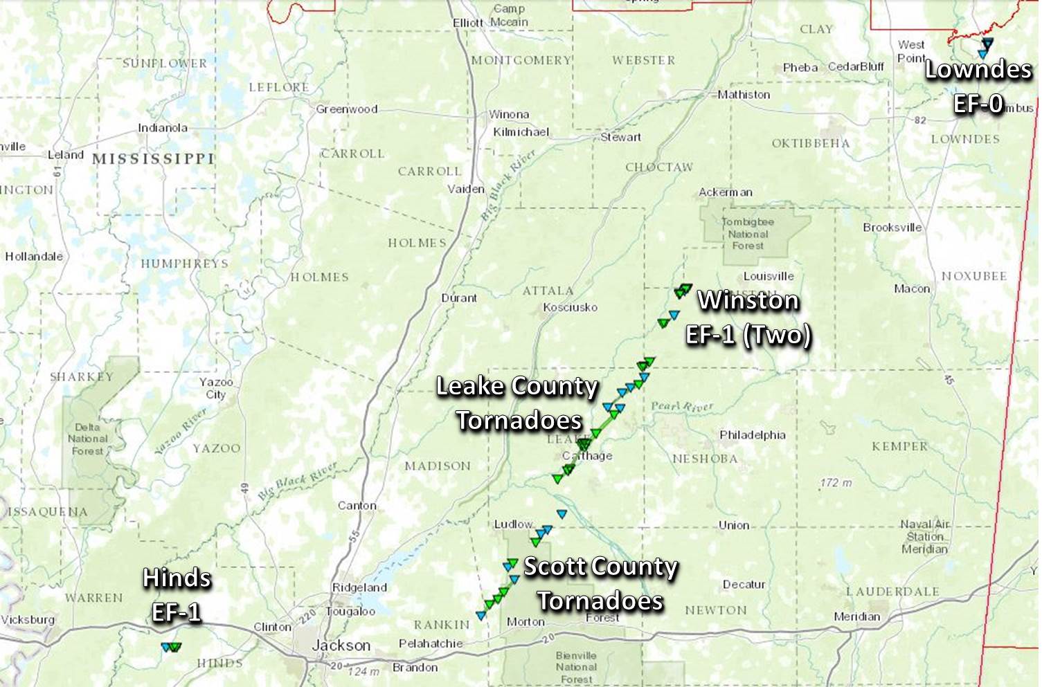
Click on map above to see entire event tracks and damage point notation.
Survey Information
Click on the location in the table for additional maps and details
| Location | Start/ End Time |
Event Type | Fatalities/ Injuries |
Path Length | Path Width |
| Hinds County 2 SE Edwards to 4 ESE Edwards |
9:33 PM- 9:35 PM |
EF-1 Tornado 100 mph |
none | 1.19 miles | 50 yards |
| Scott County 5 WNW Morton to 1 ENE Forkville |
11:40 PM- 11:50 PM |
EF-1 Tornado 110 mph |
none | 8.7 miles | 0.25 miles |
| Scott County 2 WNW Forkville to 3 N Forkville |
11:47 PM 11:51 PM |
EF-1 Tornado 90 mph |
none | 2.5 miles | 250 yards |
| Scott County 6 NNE Forkville to 5 SW Tuscola |
11:55 PM- 11:59 PM |
EF-1 Tornado 100 mph |
none | 3.0 miles | 200 yards |
| Leake County 1 SSW Tuscola to 3 WSW Tuscola |
12:05 AM 12:06 AM |
EF-0 Tornado 75 mph |
none | 0.6 miles | 75 yards |
| Leake County 4 S Carthage to 3 ENE Carthage |
12:05 AM 12:14 AM |
EF-1 Tornado 107 mph |
none | 7.4 miles | 400 yards |
| Leake County 3 E Carthage to 3.5 NW Edinburg |
12:14 AM 12:24 AM |
EF-1 Tornado 105 mph |
none | 8.1 miles | 0.25 miles |
| Leake County 2.4 SE Renfroe to 8.2 ENE Renfroe |
12:21 AM 12:31 AM |
EF-1 Tornado 95 mph |
none | 7.3 miles | 250 yards |
| Leake/Neshoba/Winston counties 4 SE Zama to 5.3 ESE Zama |
12:30 AM 12:34 AM |
EF-1 Tornado 100 mph |
none | 3.0 miles | 300 yards |
| Winston County 13.8 WSW Louisville to 11.6 WSW Louisville |
12:41 AM 12:43 AM |
EF-1 Tornado 104 mph |
none | 2.2 miles | 300 yards |
| Winston County 9.9 W Louisville to 8.4 W Louisville |
12:45 AM 12:49 AM |
EF-1 Tornado 105 mph |
none | 1.7 miles | 150 yards |
| Lowndes County 2 SE Columbus Air Force Base |
3:53 AM 3:56 AM |
EF-0 Tornado 85 mph |
none | 2.2 miles | 50 yards |
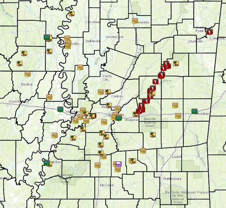
Local Storm Reports
Click on the map below for additional details.

Rainfall Totals
Storm Total Rainfall


 Follow us on YouTube