National Weather Service United States Department of Commerce
Click a location below for detailed forecast.

Last Map Update: Fri, Apr. 26, 2024 at 6:18:53 am CDT

National Weather Service Fort Worth/Dallas, TXNational Weather Service Shreveport, LANational Weather Service Jackson, Mississippi
National Weather Service Houston/Galveston, TXZoom
Out

National Weather Service New Orleans/Baton Rouge
National Weather Service National Weather ServiceNational Weather Service National Weather ServiceNational Weather Service National Weather Service

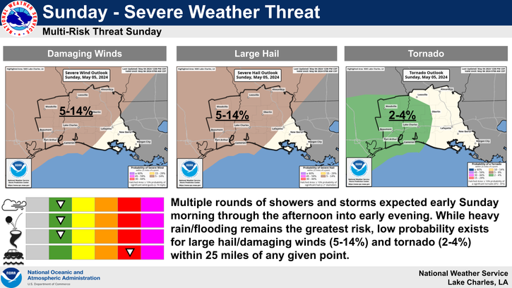
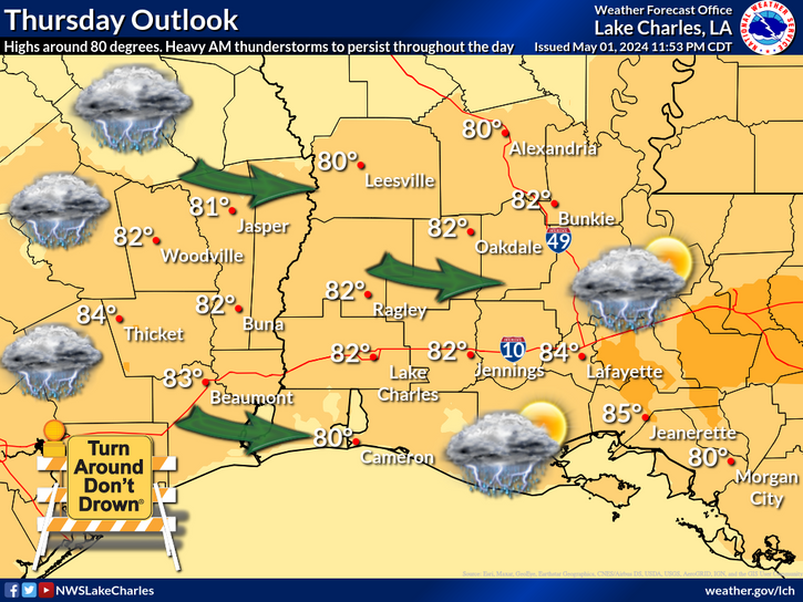
A tight pressure gradient between a High off the southeast US coast and deep low pressure over the Southern Plains will allow for windy conditions from Friday into Sunday. Sustained south winds will range from 15 to 25 mph with gusts between 30 and 40 mph. By late Sunday into Monday, a stalled frontal boundary to the north will clash with rich Gulf moisture to produce showers and thunderstorms. Some of the stronger storms will have the potential to produce heavy rainfall in a short period of time.
Partly sunny, warm, and muggy. High temperatures will be in the lower to mid 80s, except upper 70s near the coast. Winds will be mainly from the southeast at 5 to 15 mph.
Becoming mostly cloudy and muggy. Lows in the upper 60s to lower 70s. Southeast winds 10 to 15 mph.
Rainfall returns Sunday with those in Inland Southeast Texas having the chance of flooding due to excessive rainfall. 1 to 2 inches of rainfall may fall within a short time causing urban type flooding and rises on bayous, creeks and rivers.
Rainfall stalls over the region Monday and Tuesday which may lead to more flooding issues on these days.

Latest Text Product Selector
 
 
Hourly Weather Roundup ( )
Location Sky/Weather Temp Dewpt RH Wind Baro Remarks
Lake Charles
N/A
N/A
N/A
N/A
N/A
N/A
N/A
Abbeville
N/A
N/A
N/A
N/A
N/A
N/A
N/A
Alexandria
N/A
N/A
N/A
N/A
N/A
N/A
N/A
Beaumont
N/A
N/A
N/A
N/A
N/A
N/A
N/A
De Quincy
N/A
N/A
N/A
N/A
N/A
N/A
N/A
De Ridder
N/A
N/A
N/A
N/A
N/A
N/A
N/A
Fort Johnson
N/A
N/A
N/A
N/A
N/A
N/A
N/A
Jasper
N/A
N/A
N/A
N/A
N/A
N/A
N/A
Jennings
N/A
N/A
N/A
N/A
N/A
N/A
N/A
Lafayette
N/A
N/A
N/A
N/A
N/A
N/A
N/A
Nederland/Port Arthur
N/A
N/A
N/A
N/A
N/A
N/A
N/A
New Iberia
N/A
N/A
N/A
N/A
N/A
N/A
N/A
Oakdale
N/A
N/A
N/A
N/A
N/A
N/A
N/A
Opelousas
N/A
N/A
N/A
N/A
N/A
N/A
N/A
Orange
N/A
N/A
N/A
N/A
N/A
N/A
N/A
Patterson
N/A
N/A
N/A
N/A
N/A
N/A
N/A
Pineville
N/A
N/A
N/A
N/A
N/A
N/A
N/A
Sulphur/Carlyss
N/A
N/A
N/A
N/A
N/A
N/A
N/A
"N/A" or "MISG" will be displayed if values are not available. In the LOCATION column, click on links for a list of recent observations at sites of interest. In the WIND column, VRB is "variable" and G is "gust". Wind speeds are in MPH. In the BARO (pressure) column, values are in inches. In the REMARKS column, HX is "heat index", WCI is "wind chill index", and VSB is "visibility" (if shown).
 

Current Weather
 
Rivers & Lakes
 
Forecast Maps
 
Hour By Hour Forecast
 
Tropical Weather
 
Marine Forecast
 
Text Bulletins
 
Forecast Discussion
 
NOAA Weather Radio
 
Submit Storm Report