 |
| About Skywarn™... |
| The National Weather Service modernized during the 1990s, with technological advances and employee training greatly improving the warning process. |
|
| |
|
While changes have taken place, some things have remained the same. Skywarn™ has been around for several decades, and is valuable when severe weather threatens. For more about Skywarn™, click here.
|
| |
|
Each year, the value of this program is celebrated during Skywarn™ Recognition Day. For more details, click here.
|
| |
|
Read about Skywarn™ and other topics below...
|
|
|
|
Skywarn™ (formed in the early 1970s) is the National Weather Service (NWS) program of trained volunteer severe weather spotters. Skywarn™ volunteers support their local community and government by providing the NWS with timely and accurate severe weather reports. These reports, when integrated with modern NWS technology, are used to inform communities of approaching severe weather. The focus of Skywarn™ (and of the NWS) is simple...to save lives and property.
|
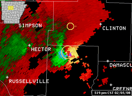 |
| In the picture: The WSR-88D (Doppler Weather Radar) Storm Relative Velocity Map (SRM) image indicates strong rotation in northern Conway County between Russellville (Pope County) and Clinton (Van Buren County) at 519 pm CST on 02/05/2008. Strong inbound winds (green/blue colors) are adjacent (gate-to-gate) to strong outbound winds (red/yellow/purple colors)...indicating a lot of rotation. In fact, the radar TVS (Tornado Vortex Signature) algorithm detected a tornado...with a red triangle placed at the center of the rotation. |
|
| |
| For a long time, the NWS has relied on radar data when issuing warnings. Since the early 1990s, the WSR-88D (Doppler Weather Radar) has provided valuable information to forecasters...with better detection of severe storm phenomena and more accurate and timely warnings. |
|
However, even with the advance in technology..."ground truth" is still a very important part of the warning process. "Ground truth" answers what exactly is going on. Is the storm tornadic? Is it producing large hail? How about damaging winds? Most of the "ground truth" is provided by trained storm spotters (through Skywarn™)...or the "eyes of the NWS."
|
|
The NWS believes so much in storm spotters (and Skywarn™) that it provides continuous training. The students are members of law enforcement, emergency management, HAM radio clubs, and are also ordinary citizens who just want to help. All that is necessary is to spend a few hours learning about severe weather...what a severe storm is, the structure of a severe storm, how it develops, and how to inform the NWS of severe weather.
|
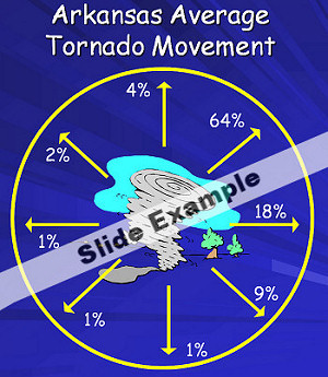 |
The course is presented in a multimedia format. Many visuals and animations are provided to make the material easier to understand.
|
| In the picture: An example of a slide in the spotter training multimedia presentation. |
|
At the completion of the course, students are eligible to receive certificates which make them official NWS storm spotters for five years.
|
|
The course is normally taught by the Warning Coordination Meteorologist (WCM) from a local NWS office. The WCM helps develop the coursework and is the liason between storm spotters and the NWS.
|
 |
|
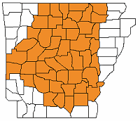
Courses through the NWS Forecast Office in Little Rock are offered in 47 counties... namely the office's County Warning Area (CWA). For a closer look at CWAs across Arkansas, click on the links below:
|
| |
| Graphical |
Text |
|
| |
| To become a trained storm spotter, you must complete the coursework provided by the NWS. The NWS often works with county emergency managers and officials to plan classes, with numerous classes given each year. |
| |
|
|
| |
| Have you considered becoming a spotter via the internet? While we try to schedule classes whenever there is a need, you may consider becoming a National Weather Service storm spotter by taking a course online. Our office accepts the online course as fulfilling all the requirements to become an official spotter. This course contains two segments that are found at the link below. |
| |
|
|
| |
|
For Skywarn™ to work, it is crucial for reports to make it from storm spotters to the NWS. The easiest way to make contact is by phone through a special 800 number.
|
|
Also, during many severe weather events...reports can be submitted through HAM radio.
|
 |
|
The Arkansas Weather Net, Inc. often provides its services at the NWS...with reports immediately relayed from HAM operators to radar operators
|
|
Reports can also be filed at this web site through a special "Weather Reporting Form." To see this form, click here.
|
|
Obviously, the reports go to the NWS. They are used both during and after severe weather events. During the events, the reports help radar operators determine what a storm is producing so they can warn counties farther downstream. After the events, the reports are used for studies. Quite often, reports are correlated with radar data to help measure the performance of the radar and to help forecasters interpret the data. In the end, forecasters end up becoming better radar operators.
|
|
|
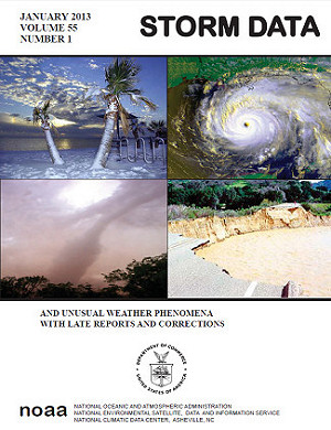
Reports are also compiled in a monthly publication called "Storm Data."
|
| Skywarn™ involves getting yourself trained to identify and report severe weather. |
| |
|
StormReady goes one step further, training communities how to prepare for severe weather.
|
 |
| Is your community StormReady? If you're not sure, or you would like to learn more about StormReady...click here |
|


 Follow us on YouTube