National Weather Service United States Department of Commerce
Fire Weather
Product Notice
If a product is not current or unavailable, try clicking the LATEST button.
 
Operating Plan
 

Do you wish to get more familiar with fire weather, and find out how the National Weather Service prepares to meet the needs of the fire weather community? Then you will want to check out the latest Arkansas Fire Weather Operating Plan (updated January, 2024). To obtain this document (file size is around 2.2 MB), click here.

Note: The document is in PDF format. If you don't have a PDF reader, you can get one free by clicking here.
 
Spot Forecast
 
Submit Spot Request | Monitor Spot Forecasts (in UTC or "Z" time)
Latest Spot ForecastsLatest Product(for the Little Rock County Warning Area only)
 
 
Arkansas Voluntary Smoke Management Guidelines for Row Crop Burning
Safety and the health of others should be considered before burning. It is generally not safe to burn when it is breezy (winds over 15 mph) and dry (humidity less than 20 percent). So that nearby towns do not get smoked out, proper ventilation is crucial. The goal is for smoke to get up and out. Ventilation increases as inversions (rising temperature with height) weaken and winds aloft (transport winds) ramp up to carry smoke away. Higher ventilation rates lead to optimal Category Day (a scale from 1 to 5) classifications. Given a Category Day of "1", smoke transport is poor, and "5" is excellent.
 
Category Day Information
Use the dropdown menu below to get the latest "Category Day" for the county of your choice. For help locating parts of counties in the list, click here.


While Category Day is a valuable predictor of fire behavior, other variables such as the Dispersion Index (a scale from 1 to 100+) should be considered. This index estimates the ability of the atmosphere to dilute smoke. Daytime values below "40" (and especially under "20") are not ideal (smoke dispersal is fair to poor), and burning is generally not recommended.


Forestry Forecast Information
 

Forestry ForecastLatest Product(for the Little Rock County Warning Area only)

Fire Weather Point ForecastLatest Product(trends of temperature, humidity, winds, etc)
 
Tabular Weather Forecasts
Cities in Arkansas Coordinates (make sure "Lon" is negative)
Lat:   Lon:
 
Try Our Clickable Maps!

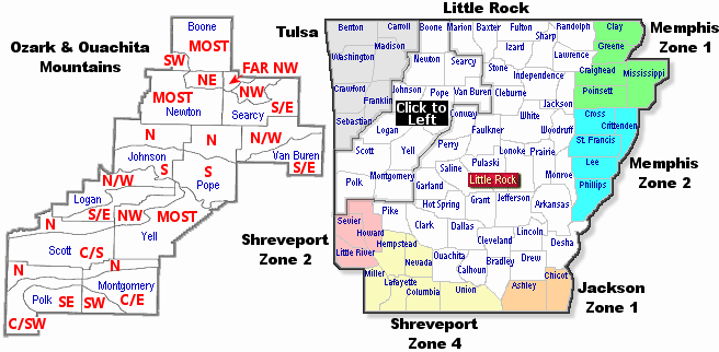
Click on the maps below to get a forestry forecast from the indicated office. For a closer look at office areas of responsibility, click here. Please Note: In the map below left, abbreviations are as follows..."N" is north, "S" is south, "E" is east, "W" is west, "NW" is northwest, "NE" is northeast, "SW" is southwest, "SE" is southeast, "C" is central, and "MOST" is most of the county. For more about the map, click here.

<<<< Click Here For a Regional Forecast >>>>

<<<< Click Here For Specific National Forest Forecasts >>>>

Little Rock - Boone County Little Rock - Boone County Little Rock - Newton County Little Rock - Newton County Little Rock - Searcy County Little Rock - Searcy County Little Rock - Johnson County Little Rock - Pope County Little Rock - Van Buren County Little Rock - Johnson County Little Rock - Pope County Little Rock - Van Buren County Little Rock - Searcy County Little Rock - Logan County Little Rock - Logan County Little Rock - Yell County Little Rock - Scott County Little Rock - Scott County Little Rock - Yell County Little Rock - Polk County Little Rock - Montgomery County Little Rock - Polk County Little Rock - Montgomery County Little Rock - Polk County Little Rock - Montgomery County Tulsa - Benton CountyTulsa - Carroll CountyTulsa - Washington CountyTulsa - Madison CountyTulsa - Crawford CountyTulsa - Franklin CountyTulsa - Sebastian CountyMemphis - Zone 2Memphis - Zone 1Shreveport - Zone 2Shreveport - Zone 4Jackson - Zone 1Little Rock - Arkansas CountyLittle Rock - Baxter County Little Rock - Boone CountyLittle Rock - Bradley CountyLittle Rock - Calhoun CountyLittle Rock - Clark CountyLittle Rock - Cleburne CountyLittle Rock - Cleveland CountyLittle Rock - Conway CountyLittle Rock - Dallas CountyLittle Rock - Desha CountyLittle Rock - Drew CountyLittle Rock - Faulkner CountyLittle Rock - Fulton CountyLittle Rock - Garland CountyLittle Rock - Grant CountyLittle Rock - Hot Spring CountyLittle Rock - Independence CountyLittle Rock - Izard CountyLittle Rock - Jackson CountyLittle Rock - Jefferson County Little Rock - Johnson CountyLittle Rock - Lincoln County Little Rock - Logan CountyLittle Rock - Lonoke CountyLittle Rock - Marion CountyLittle Rock - Monroe County Little Rock - Montgomery County Little Rock - Newton CountyLittle Rock - Ouachita CountyLittle Rock - Perry CountyLittle Rock - Pike County Little Rock - Polk County Little Rock - Pope CountyLittle Rock - Prairie CountyLittle Rock - Pulaski CountyLittle Rock - Saline County Little Rock - Scott County Little Rock - Searcy CountyLittle Rock - Sharp CountyLittle Rock - Stone County Little Rock - Van Buren CountyLittle Rock - White CountyLittle Rock - Woodruff County Little Rock - Yell CountyLittle Rock - Randolph CountyLittle Rock - Lawrence County

 
To get a forestry forecast for all counties in Arkansas, select from the list below.
Arkansas | Ashley | Baxter | Benton | Boone (Most) | Boone (Southwest) | Bradley | Calhoun | Carroll | Chicot
Clark | Clay | Cleburne | Cleveland | Columbia | Conway | Craighead | Crawford | Crittenden | Cross | Dallas
Desha | Drew | Faulkner | Franklin | Fulton | Garland | Grant | Greene | Hempstead | Hot Spring | Howard
Independence | Izard | Jackson | Jefferson | Johnson (North) | Johnson (South) | Lafayette | Lawrence | Lee
Lincoln | Little River | Logan (North/West) | Logan (South/East) | Lonoke | Madison | Marion | Miller | Mississippi
Monroe | Montgomery (Central/East) | Montgomery (North) | Montgomery (Southwest) | Nevada
Newton (Most) | Newton (Northeast) | Ouachita | Perry | Phillips | Pike | Poinsett | Polk (Central/Southwest)
Polk (North) | Polk (Southeast) | Pope (North) | Pope (South) | Prairie | Pulaski | Randolph | St. Francis
Saline | Scott (North) | Scott (Central/South) | Searcy (Far Northwest) | Searcy (Northwest)
Searcy (South/East) | Sebastian | Sevier | Sharp | Stone | Union | Van Buren (North/West)
Van Buren (South/East) | Washington | White | Woodruff | Yell (Most) | Yell (Northwest)
Latest Red Flag Warning/Fire Weather WatchLatest Product
Latest Fire Danger StatementLatest Product
Latest Single Station ForecastsLatest Product (how to decode)
 
Fire Danger Assessment