 |
| For Your Information |
| If there is something that may be of interest to you, we will try to make that information available. |
|
|
 |
New Elevation Based Zones in the Little Rock County Warning Area |
 |
| |
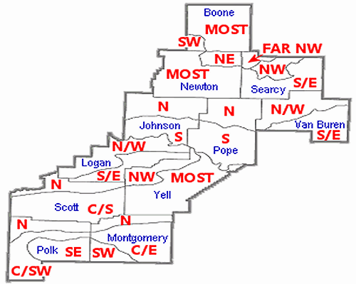 |
| In the picture: Eleven counties in the Little Rock (LZK) County Warning Area were split into twenty five zones based on elevation (mainly in the Ozark and Ouachita Mountains in northern and western sections of the state). In the map, abbreviations are as follows..."N" is north, "S" is south, "E" is east, "W" is west, "NW" is northwest, "NE" is northeast, "SW" is southwest, "SE" is southeast, "C" is central, and "MOST" is most of the county. |
|
| |
|
On April 5, 2022, eleven counties in northern and western Arkansas (Ozark and Ouachita Mountains) were split into twenty five zones based on climatological differences (mainly due to terrain) and to help forecast elevation dependent weather events more accurately. The split affected Boone, Johnson, Logan, Montgomery, Newton, Polk, Pope, Scott, Searcy, Van Buren, and Yell Counties.
|
|


 Follow us on YouTube