
Scattered strong to severe storms, excessive rainfall, and flooding are expected across parts of the Mid-Atlantic into the Northeast today. Flood Watches are in effect. Heat will continue to impact the West today. Heat advisories are in effect for portions of the Intermountain West; and Extreme Heat Warnings are in effect for portions of Arizona and southeast California. Read More >
Alec Lyster and Greg Murdoch
1. Introduction
A prescribed burn escaped on Casa Grande Peak in the Big Bend National Park on 4 May 1999 making three aggressive runs which put the lives of three fire fighters in jeopardy. Based on an operational narrative provided by the Big Bend National Park a general narrative will be given describing the fire's history. We then will attempt to relate this fire's behavior to the weather by investigating the precipitation patterns and available fuels from the perspective of the El Niño Southern Oscillation (ENSO) and the La Niña Southern Oscillation (LNSO). We will also diagnose the synoptic scale weather pattern and relate this to the attendant fire.
Over the years, fire weather has not been a high priority in west Texas, with the exception of the Guadalupe Mountains in Texas. As a result, local meteorological studies in relation to fire behavior have been nil and it is in this regard that this paper will focus. Of utmost concern to forecasters is recognizing fire weather patterns that can lead to dangerous situations. Fire management teams have long recognized the connection between critical weather elements and extreme fire behavior. This has resulted in a red flag warning program, which points out to the fire management teams that critical fire weather elements are occurring or are imminent. In hopes of establishing area-specific critical fire weather patterns, we will look for similarities by comparing this case to other documented critical fire weather patterns. Finally, we will relate some of the factors of weather and topography to specific firebrands that affected the start and spread of this wildland fire.
2. The Basin Campground Prescribed Burn
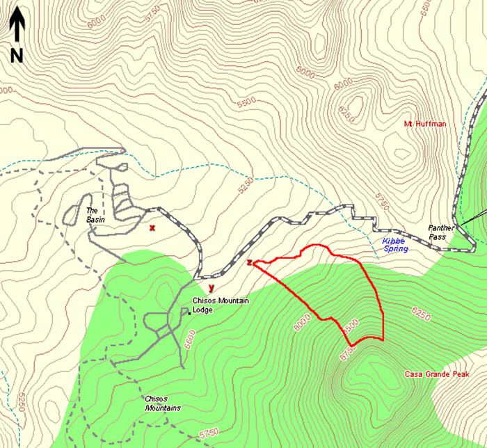
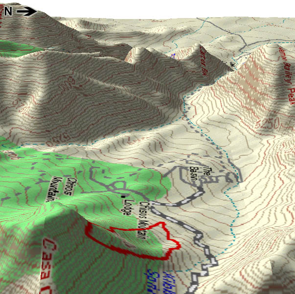
Casa Grande Peak (elevation 7325 ft) is located roughly 1476 ft south-southwest of Panther Pass and the east-west oriented Chisos Basin road (Fig. 1). A steep grade consisting of a 400 ft drop in elevation is located just north of the peak (Fig. 2). Other easily noted features include: a gradual declining ridge extending roughly 656 ft to the north-northwest from the steep grade, and an arroyo extending roughly 984 ft from the peak just to the west of the ridge.
 |
 |
The following account (Carver, et al. 1999) of the burn was taken from the Casa Grande Incident Interagency Investigative Report. A test burn was initiated at 1630 UTC on 4 May 1999 immediately south of the Basin Campground ((Fig. 1). The conditions at ignition time were: 1) ambient temperature - 70F; 2) relative humidity - 20%; and 3) west wind 2-5 mph with gusts to 10 mph. Flame lengths in grass were 8-12 inches with brush torching out. At 1648 UTC, another test burn was initiated roughly 3280 ft northwest of Casa Grande Peak with similar fire behavior noted (Fig. 1).
The enclosed area outlined in bold red on Figs. 1 and 2 indicate where the fire runs occurred. The first spot fire was reported at 1817 UTC (Fig. 1). New ignitions were halted as firefighters and equipment were re-distributed to deal with the spot fire progressing upslope and eastward. By 1900 UTC, wind speeds from the automated observations at Chisos Basin indicated a west wind of 13 mph with gusts to 29 mph. Eye level wind observations at the fire site were averaging 2-5 mph with gusts to 15 mph. The extremely dry conditions, meteorological setting, and fuel types (lechuguilla, grass, and small shrubs) allowed the fire to make several runs. The fire achieved upslope speeds of roughly 10 chains per hour (ch/hr) and downslope speeds of roughly 5 ch/hr. As the fire topped one of the drainages, two firefighters deployed their shelters while the lookouts were forced to retreat into the black (i.e. area that has already burned) west of the advancing fire. The lookouts did not deploy their shelters, but had to pass through flames approximately 18-24 inches in height.
During the night of 4 May, the wind subsided and the fire's progression slowed. A west wind increased again during the day of 5 May, and a control line at Kibbe Spring Trail was abandoned for the Chisos Basin road. Efforts succeeded late on 5 May and during the day of 6 May such that burnout operations were completed at 2323 UTC 6 May. The fire was declared controlled at 2200 UTC 7 May after a day of mop-up 1 ch deep into the black along the fire line.
3. El Niño/La Niña
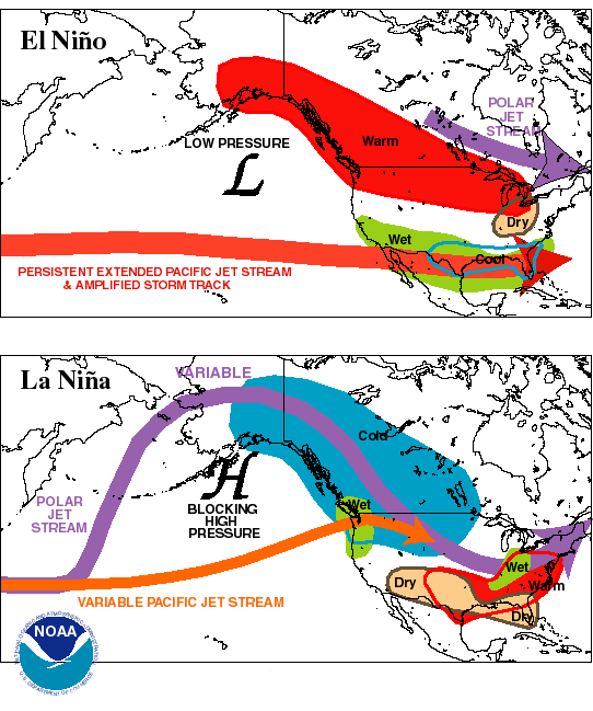
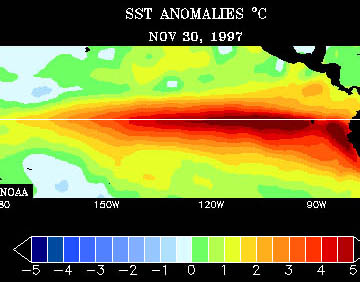
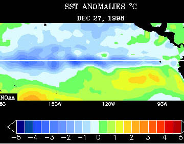
Normally, an El Niño episode favors upper air patterns conducive to cooler and wetter than normal winters across southwest Texas, while a La Niña event tends to favor drier and warmer than normal conditions (Fig. 3). The 1997/1998 El Niño (Fig. 4a), one of the strongest events on record (Bell, et al. 1998) gradually weakened during the first four months of 1998. In May/June 1998 rapid cooling of the equatorial Pacific sea surface temperatures (SST's) produced weak La Niña conditions (Fig. 4b) which progressed to a moderate La Niña episode by early 1999. The above information was taken from a February 1999 El Niño/La Niña update published on the Internet by the National Meteorological and Hydrological Services of the World Meteorological Organization Member States and affiliated users (www.wmo.ch/nino/updat.htm#intro).
 |
 |
 |
Drier than normal conditions were observed throughout southwest Texas from 1 May 1998 to 30 April 1999. Midland International Airport received only 5.74 inches of rain during this period, well below the normal of 14.96 inches. Conversely, Panther Junction in Big Bend National Park received 12.81 inches of rainfall during this span, only slightly below normal. However, from 1 January to 30 April 1999, rainfall totaled 1.74 inches at Midland International Airport which was below the normal of 2.43 inches. During the same period, Panther Junction received only 0.62 inches of rainfall.
Climatological normals already account for the drier winter and early spring months in southwest Texas, however the effects of a strengthening La Nina were evident. The adequate rainfall received during 1998 aided in green-up of Big Bend National Park, but considerable drying and lowering of fuel moisture occurred in this area during the first five months of 1999 culminating in a surplus of dry fuel by May 1999.
4. Synoptic Setting
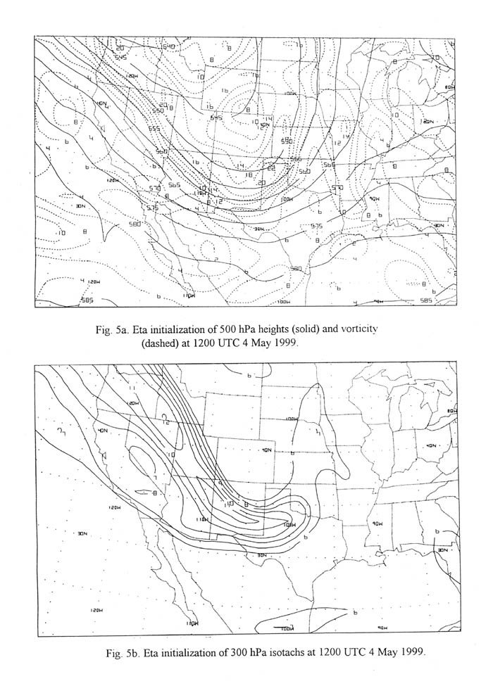
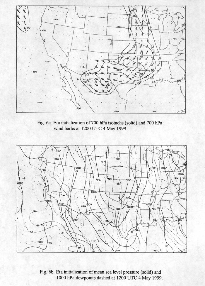
The Eta numerical prediction model's initial conditions on 1200 UTC 4 May showed a negatively tilted, longwave trough at 500 hPa digging south-southeastward into west Texas (Fig. 5a) aided by a strong 300 hPa 110 kt jet streak (Fig. 5b). A 700 hPa 45 kt jet (Fig. 6a) was progressing eastward across northern Mexico. At the surface an elongated area of low pressure lay across Nebraska, Kansas, and northern Oklahoma with a dryline extending through the eastern Texas Panhandle and Edwards Plateau (Fig. 6b).
 |
 |
As the 300 hPa jet streak progressed eastward through the southwest United States, a strong shortwave trough translated through the base of the longwave trough by 0000 UTC 5 May. Steep environmental lapse rates favored the transport of momentum from the 700 hPa wind maximum to the surface. Springtime storm systems with these attributes typically indicate potential for strong wind and little chance for precipitation across southwest Texas.
The synoptic pattern established a dry environment over southwest Texas by 1200 UTC 4 May. Dewpoints were 32- 41F at the surface and 23- 32F at 850 hPa. In addition,1-hour fuel moistures were at or near record lows of 1.5% - 3%. As surface cyclogenesis occurred over the central U.S. plains in response to the ejecting shortwave trough, a tightening of the surface pressure gradient occurred. This surface pressure gradient and the passing of the 700 hPa 45 kt jet (Fig. 6a) resulted in increased surface winds and assisted in drying the air from already low morning dewpoint readings.
The present synoptic scale pattern would raise concerns of gusty west winds funneled in some locations by the terrain. This burn site was susceptible to funneling of west winds due to a break in the mountainous terrain directly west of the site (Fig. 2). A critical fire weather day was occurring due to very low fuel moisture and drier air mixing down to the surface.
5. Critical Fire Weather Patterns
Critical fire weather results from environmental factors which significantly enhance the threat of large and destructive wildland fires (National Fire Weather Forecasters Training Course, 1998). Included in these environmental factors are: available fuels, strong wind, low atmospheric moisture, and instability. Available fuels significantly enhance the threat for wildland fires when the fuel moisture content is low enough for fuels to become combustible.
Strong wind adds oxygen to the fire and can significantly increase the intensity and rate of spread of the fire. Short term changes in atmospheric moisture and 1-hour fuel moisture content are directly related. During times of low atmospheric moisture, the moisture content of available fuels may become low enough for combustion. The more unstable the environment, the more oxygen will be available for a fire. Additionally, an unstable environment will also tend to enhance the transport of firebrands, thereby increasing the likelihood of spotting.
The following information on Critical Fire Weather Patterns was taken from the S-591 National Fire Weather Forecasters Training Course (1998). Schroeder (1969) found that most periods of critical fire weather are commonly associated with surface anticyclones (cold frontal passages) and upper level ridges (results in a hot dry pattern) or the dissipation of such features. Schroeder found that there are two exceptions to these scenarios: 1) Chinook winds in the lee of the Rockies; and 2) the dry windy area of a tropical storm circulation. Our case study falls into the Chinook wind type scenario. A Chinook wind (i.e. a downslope wind in west Texas and southeast New Mexico) is common across the Big Bend in the winter and spring.
The use of the term "downslope" here is different from the "downslope wind" or "down valley wind" that is part of the nocturnal wind pattern circulation that develops in mountains and is a result of cooling and gravity, but is that part of the general wind that is associated with the synoptic scale pattern. Since the mountains act as a barrier to the return of moisture from the Gulf of America, the airmass west of the Texas mountains is usually dry. The developing west downslope wind serves to dry and warm the airmass further through adiabatic descent, aiding in the formation of the dryline. Casual observations of moisture and wind across the Big Bend, west of the spring and fall dryline, suggests that the most common critical fire weather factors present will be low atmospheric moisture and occasionally wind. A fire weather forecaster needs to recognize patterns which will favor low atmospheric moisture (15%) and significant 20 ft winds (22 kt). This is the criteria established for issuing a red flag warning for the Davis and Chisos Mountains. Knowing the typical seasonal and diurnal patterns across west Texas suggest that the downslope wind pattern will be the most common critical fire weather pattern.
There are certainly other critical fire weather patterns that develop across west Texas and southeast New Mexico. For instance, the unusually strong ENSO of 1998 primed the environment for aggressive fire behavior across the Chinati Mountains as spring green-up was significantly inhibited. In May 1998 a broad expanse of high pressure developed aloft across the southwestern U.S.. This interrupted the season diurnal pattern of thunderstorm development in the mountains of west Texas, during which time a prescribed burn in southern Presidio County escaped burning over 50,000 acres.
6. Firebrands and Factors of Topography
According to National Wildfire Coordinating Group (1994) a firebrand is "any source of heat, natural or manmade, capable of igniting wildland fuels. Flaming or glowing particles that can be carried naturally by wind, convective currents, or by gravity into unburned fuels." Spotting, fire whirls, and rolling logs are examples of firebrands. The National Wildfire Coordinating Group says spotting is "a fire behavior characteristic by which sparks or embers are carried by the wind and/or convective column which ignites additional fires beyond the zone of direct ignition by the main fire". Spotting is related to the wind speed and the wind speed influences the depth of the convective column. Strong flame length level winds will typically result in embers being carried downwind for relatively short distances. The depth of the convective column has a greater effect on the spotting distance. Deep (shallow) convective columns tend to form in light (strong) winds which lift embers higher (lower) favoring a longer (shorter) spotting distances.
According to the incident report on the Casa Grande Fire, spotting was the mechanism by which new fires were started, while observations from the fire suggest the convective column varied from a well defined plume rising several hundreds of feet to a sheared plume confirming the gustiness of the winds. Measurements indicate the spotting occurred at a distance of 10 ch (700 ft). From the test burn site these spot fires developed on the north aspect of the Casa Grande Peak making several upslope runs. The increased wind speed noted around 1900 UTC increased the forward speed of the fire upslope to roughly 200 m/hr (656 ft/hr or 10 ch/hr). Another interesting aspect of the fire's behavior was in the drainages. Drainages on Casa Grande Peak can be describe as narrow channels extending up the mountain and observations from the fire suggest that there may have been a "Chimney Effect" in a drainage. Fires near the base of a drainage tend to draw air into the fire, creating potentially dangerous winds which may result in rapid spread of the fire. A rapid spread of the fire was not observed in the drainage, however this did appear to facilitate the spotting process as the fire jumped up 200 ft cliff bands reaching the top of Casa Grande Peak, a vertical leap of some 500 ft.
7. Conclusion
Fire weather forecasting is a significant challenge due to the specificity of the forecast. This is exacerbated by the affects that terrain can have on the local weather such as: mountain/valley circulations, differential heating of slopes, rain shadows, and channeling of winds to name a few. Planetary circulation patterns can play a role in setting the stage for aggressive localized fire events. A wet season with above annual growth that is related to the ENSO can turn dangerous as a drier LNSO pattern evolves and persists. This was the case during the 1997/1998 ENSO episode as abundant rain fell across the Big Bend resulting in new fuel growth. The transition to the drier LNSO pattern led to an abundance of cured fuels by May 1999.
Critical fire weather patterns are generally unique because of the topography and geographic location in relation to moisture sources. Forecasters should be keenly aware of conditions that may perpetuate existing controlled fires into additional wildland fires. During the spring a diurnal oscillation of the downslope wind is common, however this occurs in varying degrees. A forecaster needs to recognize and anticipate evolving critical fire weather patterns so effective preventive fire planning strategies can be implemented.
The development of the downslope wind aggravated a sensitive environment in which 1-hour fuels were dangerously low (around 1.5% -3% ). Forecasters should also be cognizant of the potential for firebrands and effects of topography. During the Casa Grande incident, firebrands and topography contributed greatly to the spread of the fire as the strong winds resulted in short-range spotting. Upslope and across slope winds contributed to the run and spread of the fire. Thus, to provide an effective fire weather forecast, forecasters are tasked with assimilating a variety of information regarding weather, fuels, topography, and basic fire behavior.
8. Acknowledgments
The authors thank Brian Francis, Science and Operations Officer at Midland, TX, Loren Phillips, Science and Operations Officer at Lubbock, TX, and John Morlock, Fire Weather Officer at the Big Bend National Park for their helpful insight and reviews. Also a special thanks is extended to Dan Koch, Senior Forecaster at Midland, for his help with the graphics.
References
Bell, Gerald D., Michael S. Halpert, Vernon E. Kousky, Melvyn E. Gelman, Chester F. Ropelewski, Arthur V. Douglas, Russell C. Schnell, 1999: Climate Assessment for 1998. Bulletin of the American Meteorological Society: Vol. 80, No. 5, pp. 1040-1040.
Carver, G., P. Garcia, T. Sexton, D. Lentz, 1999: Casa Grande Incident Interagency Investigation Report, 1999.
National Wildfire Coordinating Group, Intermediate Wildland Fire Behavior Course S-290, Glossary, 1994.
Schroeder, M.J., 1969: Critical Fire Weather Patterns in the Conterminous United States. ESSA Technical Report, WB 8. 31 pp.
U.S. Dept of Commerce National Oceanic and Atmospheric Administration, National Fire Weather Forecaster's Training Course S-591, Unit II-C, 1998: Critical Fire Weather Patterns.
1999 "El Niño/La Niña Update No.8". In "El Niño/La Niña". https://www.wmo.ch/nino/updat.htm#intro. February 18, 1999.

