
Hurricane Georges - September 28, 1998
 Hurricane Georges formed on September 15, 1998 as a tropical depression 300 miles south-southwest of the Cape Verde Islands in the far eastern Atlantic. Georges strengthened to a hurricane on September 17th and reached Category 4 intensity on September 19th. Georges tracked across Puerto Rico, the island of Hispaniola, and eastern Cuba from the evening of the 21st through the 24th. The track over the mountainous terrain weakened Georges to a Category 1 hurricane. However, Georges began to re-intensify as it trekked north of the Cuban coast and tracked west-northwest toward the Gulf waters.
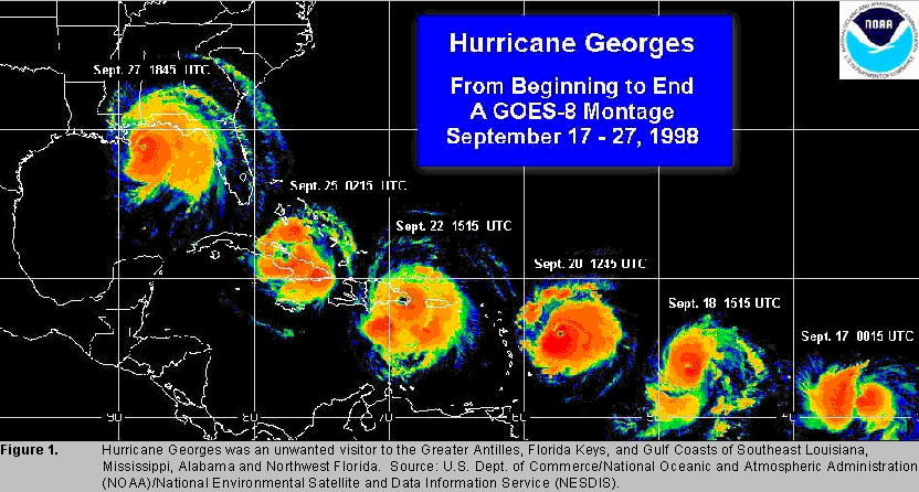
Hurricane Georges made landfall in Key West, FL on the morning of the 25th as a Category 2 hurricane. The hurricane maintained Category 2 intensity as it tracked through the Gulf. For the second time in less than a month, the northern Gulf Coast was again threatened by a hurricane! Georges made landfall near Biloxi, MS in the early morning hours of September 28th with maximum winds of 110mph and a minimum pressure of 964mb. After landfall, Georges moved very slowly across southern Mississippi and weakened to a tropical depression by the morning of the 29th when the center was about 30 miles north-northeast of Mobile, AL. The storm dissipated near the northeast Florida and southeast Georgia coast by the morning of October 1, 1998. A GOES-8 Satellite montage displaying the track of Hurricane Georges from September 17 - 27, 1998 is displayed above.
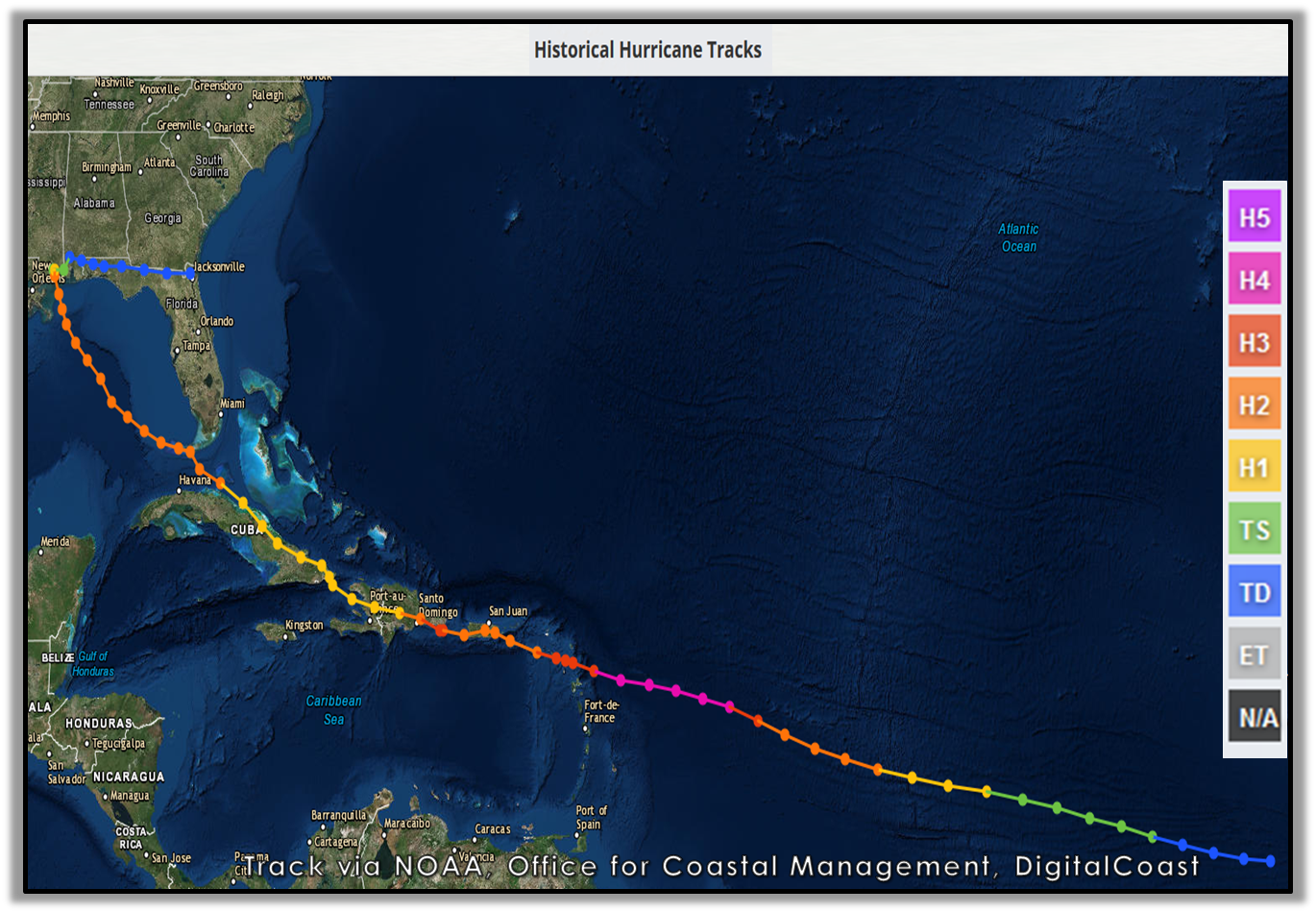
Photo courtesy of NOAA, Office for Coastal Management, DigitalCoast
There was only one fatality reported in the mainland United States directly related to the hurricane. That lone fatality occurred in Mobile, AL due to freshwater flooding. In Escambia County, FL, there were 3 fatalities indirectly related to Georges.
Insured property damage was estimated to have cost 2.955 billion dollars in Florida, Alabama, Mississippi, and Louisiana. Throughout the area, agriculture took a beating with the cotton, soybean, and pecan crop almost totally destroyed. Across northwest Florida, it was estimated that damage to agriculture was in the range of 20-25 million in losses to cotton, soybeans, peanuts, and chickens due to Georges.
Hurricane Georges was a slow-moving storm that dropped a significant amount of rain across the area, thus the majority of this document will focus on the impacts along the track across our area. Below are some of the regional impacts...
Jump to - Storm Surge, Rainfall, Wind, Animations, Imagery, or Additional Information sections.


Radar Imagery near landfall from KMOB Radar IR Satellite image near landfall on the Mississippi Coast
 Storm Surge NOTE: The original storm surge values during Hurricane Georges were denoted in MSL (mean sea level), but we currently measure storm surge in MHHW (mean higher high water). We have inserted the rough conversion to MHHW in italicized brackets [ ] next to each MSL range. All numbers are in feet (ft).
Hurricane Georges produced a storm surge of 7-12 ft MSL [6.2-11.2 ft MHHW] in Mobile and Baldwin Counties with a 5-10 ft MSL [4.2-9.2 ft MHHW] across the western Florida Panhandle, which caused extensive damage across coastal communities. The tidal gauge at the Mobile State Dock reported a peak surge of 8.94 ft MSL [8.13 ft MHHW], which is slightly higher than the 8.05 ft MSL recorded during Hurricane Frederic in 1979. The USGS Post-Storm Report also listed a storm surge of 8.80 ft MSL [7.9 ft MHHW] in Bayou La Batre. Many homes and businesses sustained damage from water in Bayou La Batre. The road parallel to Mobile Bay near Nan Seas got washed out due to storm surge.
A storm surge of 8.0 ft MSL was observed along the Causeway over Mobile Bay. Many businesses along the Causeway were damaged by the surge. The photo on the right shows the extent of the storm surge along the Causeway (courtesy of the University of South Alabama, photo by Kiichiro Sato, Mobile Register). There was a report that a male clung to a tree along the Causeway for nearly 24 hours to escape the high water. The high surge overtook the building where the male was located and he sought refuge in a tree once the building was destroyed. He was able to tread to another building after the water retreated and was found the next day.
The surge on the west end of Dauphin Island caused the most damage across the area. The USGS Post-Storm Report listed a storm surge of 5.6 ft MSL [4.96 ft MHHW]. 80 houses were damaged on Dauphin Island and nearly 40 were completely destroyed. Many gulf-front homes on the west end of the island were pushed across the island and ended up either against other homes or scattered across the sand.
Peak water level at the Pensacola gauge in the western Florida panhandle was 4.85 ft MSL [4.01 ft MHHW] while the USGS Post-Storm Report listed a storm surge of 5.2 ft MSL [4.4 ft MHHW] in the Ft Walton/Destin area. Major beach erosion occurred along the coast from Dauphin Island to Destin. High water breached Dauphin Island, Pensacola Beach, and Navarre Beach in several locations. Several motels from Gulf Shores to Destin suffered major damage. Two condominiums were heavily damaged in Orange Beach - one by fire and the other by high waves. Some of the motels that suffered damage were still closed nearly 2 months after the storm. Sand pushed in by the high water caused several coastal roads to be closed from Dauphin Island to Destin. Some of the roads were completely washed away and the roads had to be completely rebuilt on Dauphin Island, Pensacola Beach, and Navarre Beach. Some of the roads were still closed 2 months after the storm.

Before and After Picture of the West End of Dauphin Island, AL (Courtesy: USGS)
The slow movement of Hurricane Georges as it made landfall resulted in excessive rainfall and significant flooding across the region. Munson, FL (located in northeast Santa Rosa County) reported the highest storm total of 38.46 inches! Numerous other locations received between 1-2 feet of rain during Georges. The highest rainfall totals recorded across the area are summarized in the table below.

 Rainfall estimates were as high as 20-30 inches across Escambia County, FL, which can be seen in the WPC rainfall graphic on the right. Schools were closed for 3 days across the county due to the extensive flood damage to secondary roads. Many dirt roads in the rural parts of the county were completely washed away. Many bridges in the county were undermined by the high water and had to be closed. I-10 was closed due to high water near the Alabama/Florida state line. The NOAA Weather Radio transmitter was knocked off the air for more than a day as the building that housed the radio equipment had 2 feet of water in it and this shorted out the transmitter. The heavy rains also caused extensive river flooding in the county. The Perdido River crested at 26.3 feet, which was above the previous record of 23.94 feet. The Escambia River also recorded near record levels with a crest of 23.9 feet on September 30. This was almost as high as the record flood of 24.2 feet in March of that same year.
Rainfall estimates were as high as 15-25 inches across the rest of southwest Alabama, southeast Mississippi, and the northwest Florida panhandle. Most of the roads in the county had some form of flood damage with many roads closed for several days. Many bridges had to be closed because of possible undermining by high water. I-10 was closed both east and west of Crestview for several hours due to water flowing across the interstate. Schools were
closed for 2-3 days because the secondary roads were washed out. Many
secondary roads were closed for days because of a lack of people to repair them.
 The heavy rainfall and resulting runoff caused record river flooding throughout the county. The Blackwater River at Baker reached a reading of 25.57 feet on September 29, which was near the record of 25.61 feet in June of 1970. The Yellow River at Milligan crested at 24.09 feet on October 1, which was about 4 feet above the record of 20.32 feet in March of that same year. The Shoal River at Crestview crested at 21.4 feet on September 30, which was about 6 feet above the record of 15.58 feet in August of 1975. The Conecuh River at Brewton crested at 23.5 feet on October 4 which was 6.5 feet above flood stage. The Perdido River that separates Alabama and Florida crested at 26.30 feet which was above the record of 23.94 feet. The Styx River crested at 28.6 feet which was estimated to be a 200-year flood. The Fish River crested at 17.31 feet, which was lower than during Hurricane Danny of the previous year but still a 25-year flood. Many homes along these rivers were either destroyed or suffered major damage. The picture to the right is a home flooded in Seminole, AL (courtesy of the University of South Alabama, John David Mercer, Mobile Register).

Storm Total Precipitation from the KMOB Radar during Hurricane Georges.
Surface observations indicate sustained hurricane force winds were confined to the Mississippi Gulf Coast. The highest sustained winds recorded in Mobile were between 50-55mph with gusts near 65mph. The Pensacola area saw similar sustained winds. However, peak gusts of 79 and 91mph were recorded at Eglin AFB and Hurlburt Field, respectively. These higher gusts occurred in a strong convective outer band of Hurricane Georges. A C-MAN station located at Dauphin Island, AL reported a maximum sustained wind of 68mph with a peak gust of 82mph.
Georges made landfall near Biloxi with a minimum pressure of 964mb. The lowest pressure recorded in the NWS Mobile County Warning Area was 987mb at Dauphin Island. Mobile Regional Airport recorded a minimum pressure of 989.9mb.
Most of the inland counties across southeast Mississippi and southwest Alabama had damage from trees and powerlines being blown down by the persistent winds. One of the hardest hit areas by the high winds was Stone County, MS near where the center of Georges moved. 85 houses were damaged in Stone County by the wind - 54 houses sustained minor damage, 26 had major damage and 5 houses were completely destroyed. The worst of the damage was confined to the area along and east of Highway 49.


Animations
Animated GOES-8 Visible Satellite Imagery
Animated GOES-8 Enhanced Infrared Satellite Imagery
Imagery
NASA Sprite Imagery Above Hurricane Georges
NOAA HRD Satellite Imagery
More Information (Technical Papers and Reports)
NHC Advisory Archive
WPC Advisory Archive
NCDC Special Report - Georges
NHC Tropical Cyclone Report - Georges
USGS Report on Georges
FEMA Gulf Coast Report on Georges
Hurricane Georges Impacts - University of South Alabama
NWS Local Write-Ups and Webpages:
NWS San Juan, PR
NWS New Orleans
NWS Birmingham
Acknowledgments: Page created by Morgan Barry (forecaster), Jason Beaman (WCM), and Don Shepherd (senior forecaster, Tropical Focal Point). Page updated by Morgan Barry.
LAST UPDATED: September 2023

