Overview
Upper level high pressure set up across the region to end the month of June and lasted through the 4th of July holiday week. This resulted in high temperatures routinely reaching into the low to mid 90s across the Quad State region. Oppressive humidity levels were in place much of the time as well, with dewpoints up into the mid to upper 70s on a daily basis. We even had some dewpoint temperatures hit 80 degrees, which is considered extremely oppressive and uncomfortable. This resulted in daily heat index readings of 100 or above for 7 straight days. The most intense heat and humidity occurred on July 5th when high temperatures reached into the mid to upper 90s and heat index readings soared to between 110 and 115 across much of the region.
Graphics:
Observed Heat Index Readings Friday June 29th through Thursday July 5th, 2018
.gif) |
Table:
The table below shows the maximum daily heat index readings observed at all airport locations (ASOS/AWOS) and Kentucky Mesonet stations across our 58 county forecast area. These are the most reliable and accurate stations across the region. The bottom row of the chart gives the highest daily heat index reading observed across the area from these 32 stations. The heat index is calculated from a combination of air temperatures and dewpoint temperatures or relative humidity.
Maximum Daily Heat Index Readings:
| Location | State | Station Type | June 29 | June 30 | July 1 | July 2 | July 3 | July 4 | July 5 |
| Cape Girardeau | MO | ASOS | 102 | 103 | 105 | 105 | 102 | 102 | 107 |
| Carbondale | IL | ASOS | 106 | 105 | 105 | 102 | 102 | 103 | 109 |
| Evansville | IN | ASOS | 103 | 102 | 103 | 105 | 98 | 108 | 107 |
| Paducah | KY | ASOS | 102 | 106 | 103 | 106 | 102 | 110 | 114 |
| Poplar Bluff | MO | ASOS | 108 | 107 | 107 | 107 | 103 | 105 | 113 |
| Cairo | IL | AWOS | 100 | 105 | 108 | 105 | 103 | 106 | 110 |
| Murray | KY | AWOS | 100 | 100 | 105 | 105 | 103 | 107 | 111 |
| 3 WNW Fort Campbell North | KY | AWOS | 97 | 98 | 102 | 101 | 99 | 108 | 105 |
| 3 WSW Owensboro | KY | AWOS | 103 | 103 | 106 | 106 | 102 | 108 | 109 |
| Mayfield | KY | AWOS | 98 | 102 | 103 | 103 | 100 | 107 | 110 |
| Henderson | KY | AWOS | 103 | 102 | 106 | 102 | 102 | 109 | 114 |
| Madisonville | KY | AWOS | 105 | 102 | 107 | 105 | 106 | 112 | 113 |
| Mt Vernon | IL | AWOS | 105 | 109 | 105 | 100 | 108 | 109 | 107 |
| Metropolis | IL | AWOS | 102 | 105 | 106 | 107 | 105 | 107 | 112 |
| Harrisburg | IL | AWOS | 103 | 108 | 106 | 108 | 106 | 109 | 112 |
| Fairfield | IL | AWOS | 102 | 103 | 104 | 100 | 101 | 106 | 106 |
| Carmi | IL | AWOS | 106 | 106 | 108 | 111 | 106 | 111 | 113 |
| Marion | IL | AWOS | 105 | 107 | 106 | 106 | 105 | 105 | 110 |
| 1 ESE Princeton | KY | Mesonet | 99 | 102 | 106 | 102 | 102 | 107 | 110 |
| 1 W Murray | KY | Mesonet | 99 | 102 | 106 | 105 | 103 | 110 | 111 |
| 6 NNW Hopkinsville | KY | Mesonet | 102 | 102 | 105 | 103 | 101 | 108 | 109 |
| 3 NE Marion | KY | Mesonet | 103 | 102 | 105 | 104 | 104 | 106 | 111 |
| 1 ENE Hickman | KY | Mesonet | 101 | 106 | 108 | 108 | 103 | 110 | 112 |
| 3 NNE Wingo | KY | Mesonet | 102 | 106 | 108 | 107 | 103 | 110 | 112 |
| 4 ESE Henderson | KY | Mesonet | 104 | 103 | 106 | 105 | 103 | 109 | 112 |
| 1 E Earlington | KY | Mesonet | 103 | 102 | 106 | 108 | 103 | 109 | 111 |
| 4 NNE Benton | KY | Mesonet | 98 | 102 | 106 | 103 | 101 | 109 | 111 |
| 5 NW Calhoun | KY | Mesonet | 103 | 105 | 108 | 108 | 106 | 111 | 112 |
| 1 WSW Central City | KY | Mesonet | 103 | 103 | 108 | 106 | 103 | 109 | 112 |
| 3 NE Trenton | KY | Mesonet | 103 | 105 | 106 | 108 | 102 | 113 | 115 |
| 3 SW Cadiz | KY | Mesonet | 99 | 102 | 106 | 103 | 103 | 107 | 113 |
| 1 ENE Breckinridge Center | KY | Mesonet | 102 | 103 | 106 | 103 | 103 | 108 | 112 |
| Daily Maximum: | 108 | 109 | 108 | 111 | 108 | 113 | 115 |
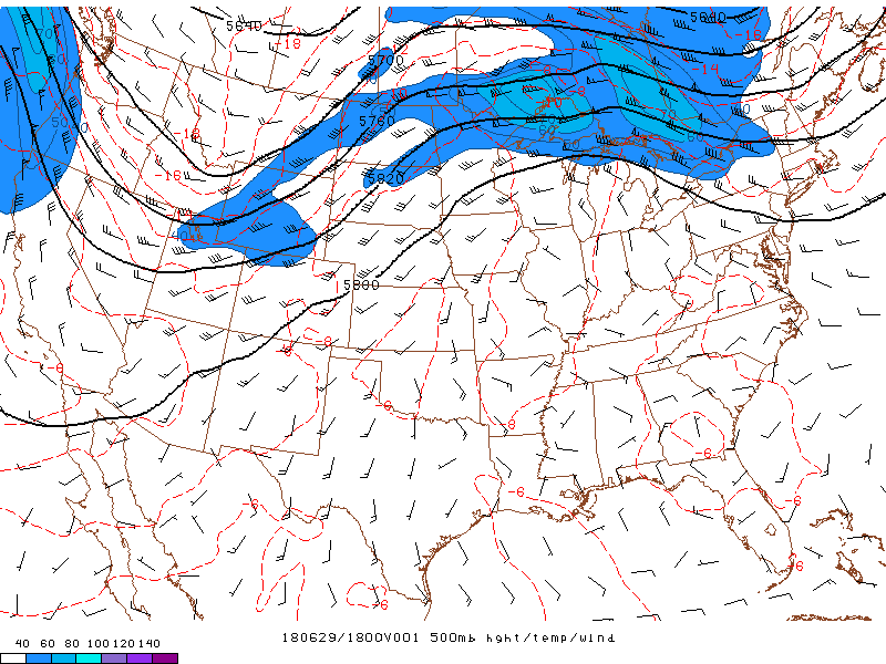
Upper Level Pattern
The graphic below shows a 7 day loop of observed 500 mb heights, wind, and temperature. This shows the overall weather pattern approximately 20,000 feet above the surface. The higher heights are indicative of upper level ridging which was located over our region on June 29th. The center of this ridge axis became oriented across the northeast U.S. by July 1st and 2nd before migrating back westward toward the Ohio Valley region for July 4th and 5th. The shortwave trough affecting the upper Midwest on July 1st didn't bring our region any relief. Thus an extended period of heat and humidity set up for the 4th of July holiday week.
 |
 |
Media use of NWS Web News Stories is encouraged! Please acknowledge the NWS as the source of any news information accessed from this site. |
|

