Overview
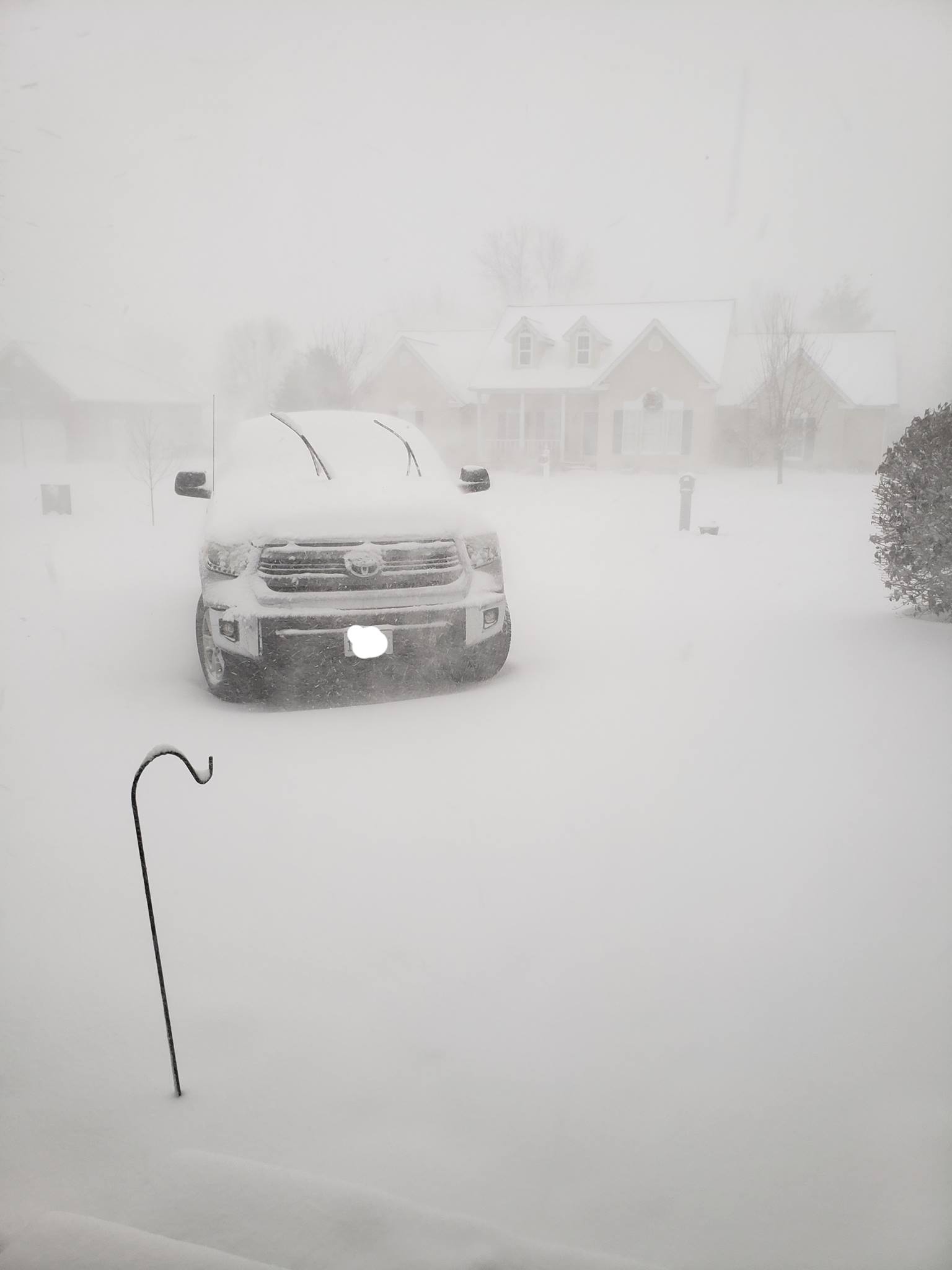
A strong storm system moved into the region on January 19th. As colder air quickly pushed southward, rain changed to snow as early as late morning in the Missouri Ozark Foothills. The changeover then worked eastward through the afternoon and early evening hours. Travel impacts were high, due to the combination of high snowfall rates (1-2" per hour), strong winds of 35-45+ mph, and rapidly falling temperatures below freezing. Roads quickly became snow and ice covered, and visibility was very low. Near-blizzard like conditions were experienced briefly in many areas. There were numerous accidents reported and some roads were closed for a while during the heart of the event. I-57 in southern Illinois was among the worst hit, which caused the Illinois State Police to close the interstate from Mount Vernon to Marion for a period of time on the evening of the 19th.Snow Amounts
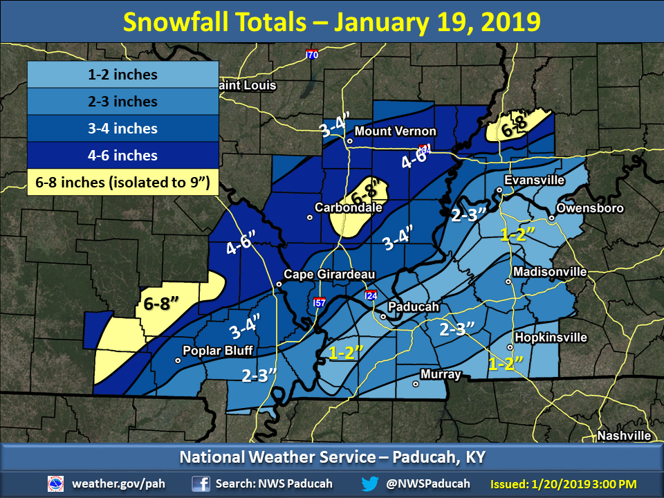
Here are the observed snowfall totals from the January 19th system across our region. The heaviest snowfall totals were observed across portions of southeast Missouri, southern Illinois, and southwest Indiana, generally from around Ellsinore and Cape Girardeau, MO, to Marion and Carmi, IL, and Princeton and Petersburg, IN. Widespread snowfall totals of 4 to 6 inches occurred in this band, with pockets of 6 to 8 inches, and locally up to 9 inches in a few towns. Across the Missouri Bootheel into western Kentucky and the Evansville, IN area, totals ranged from 1 to 3 inches. This snowfall map may be up to several inches higher than the current snow depth, due to various factors, like snow melt and compaction. Measuring the snowfall accurately was a challenge, due to the strong winds in place throughout the afternoon and evening hours. Convective elements, including thundersnow, helped enhance totals in some locations, like Marion, IL.
 |
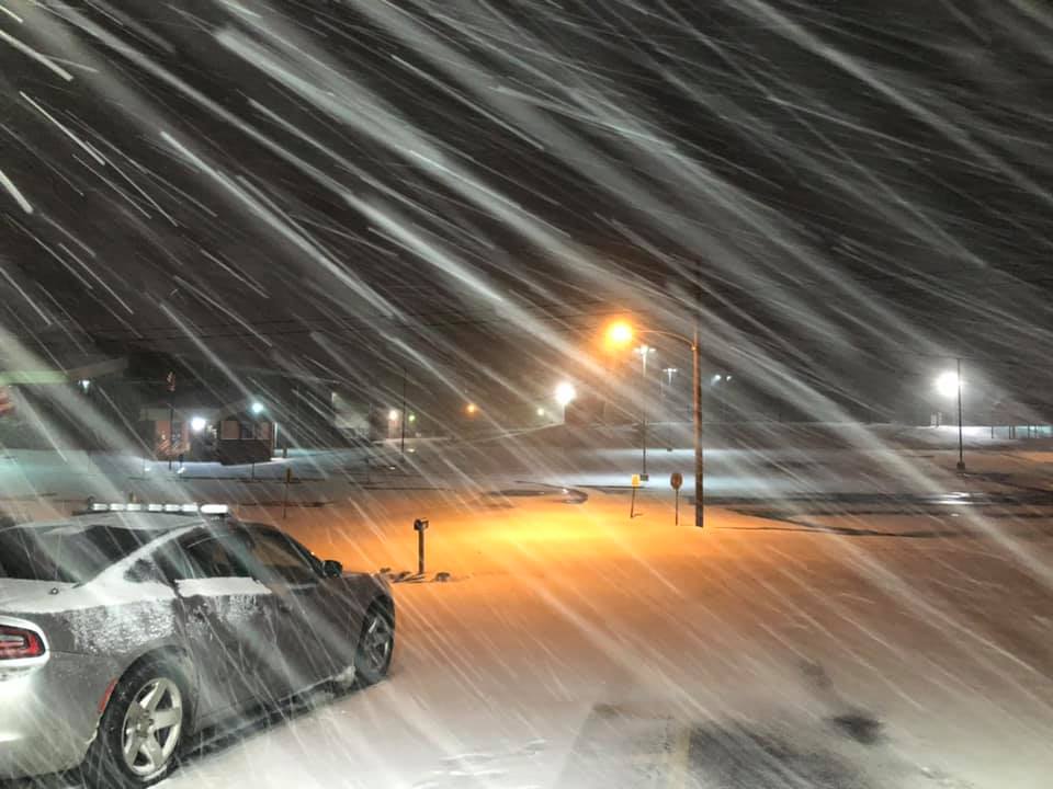
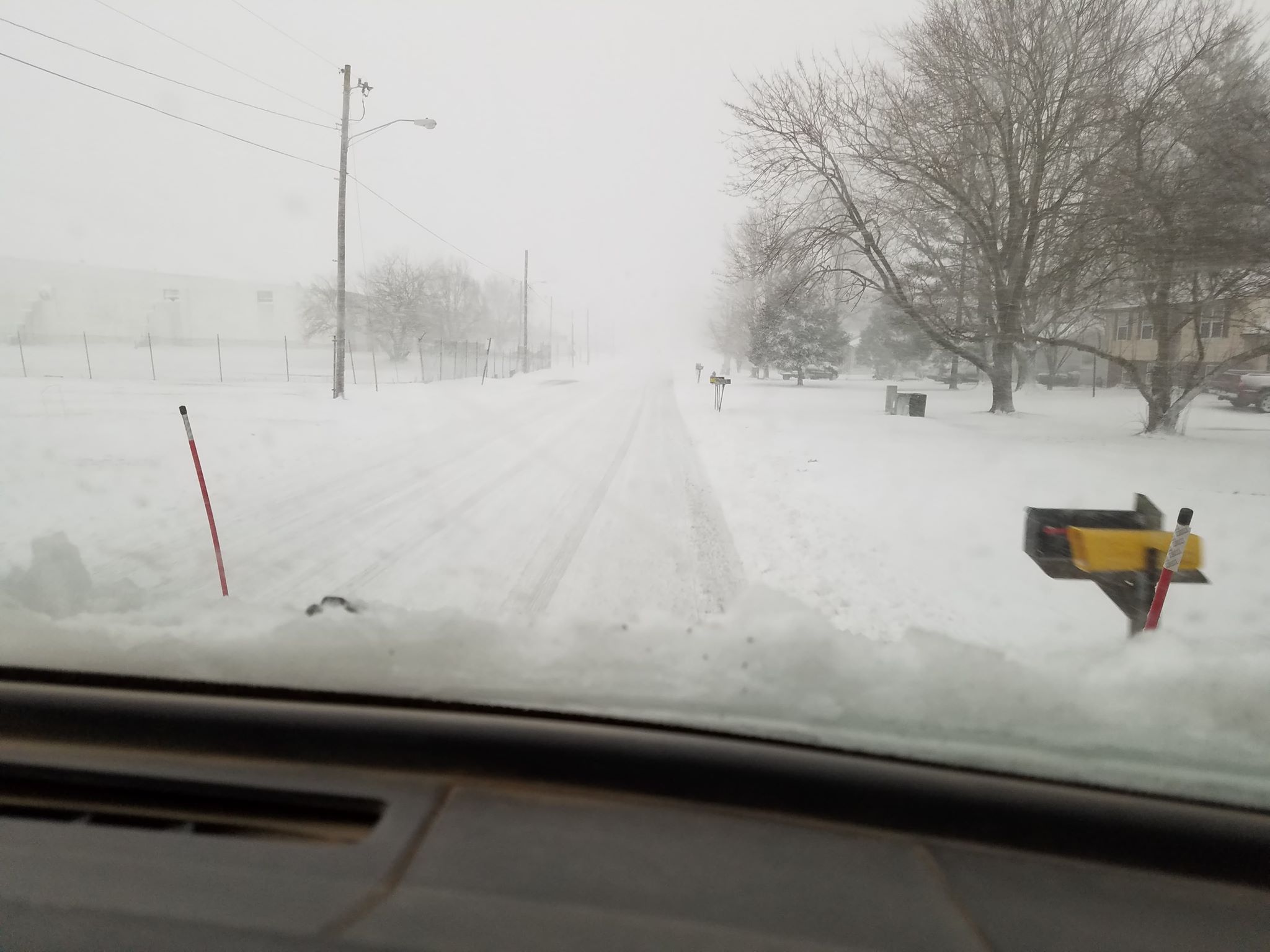
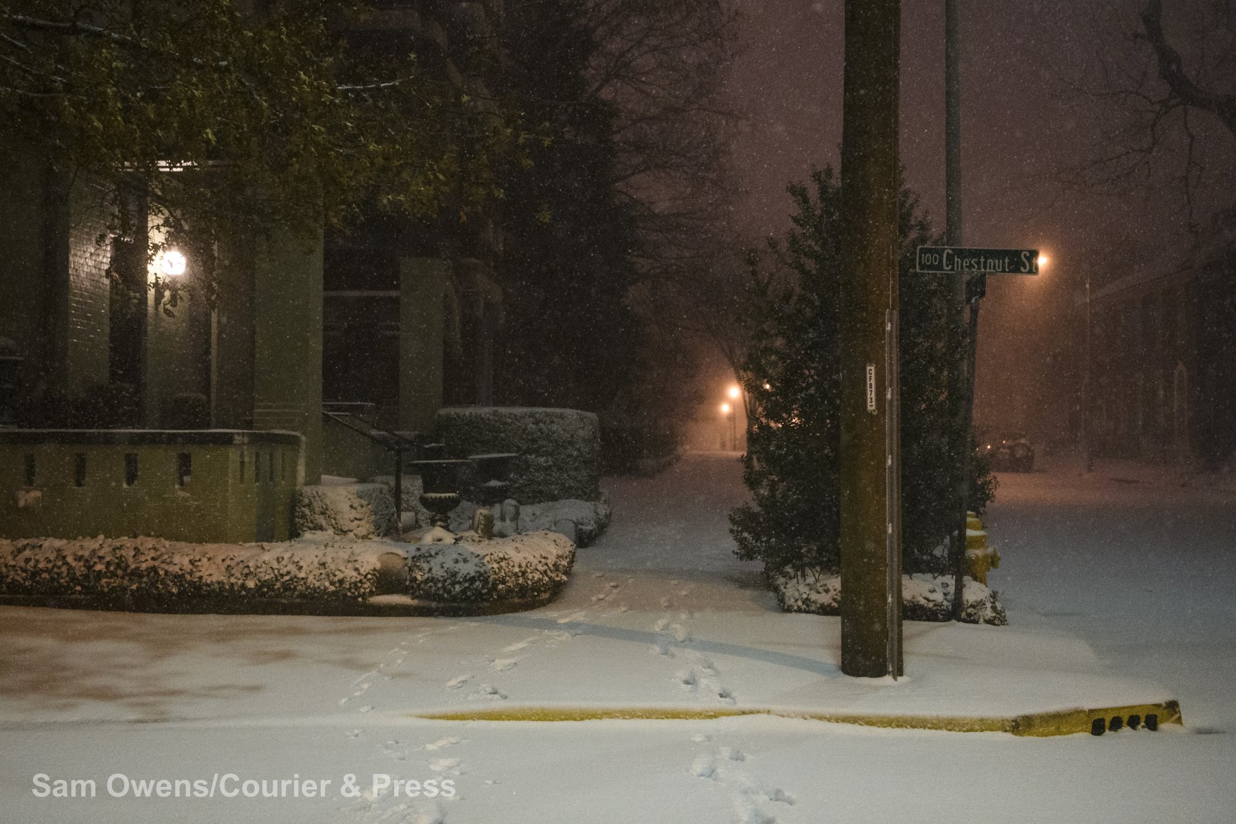
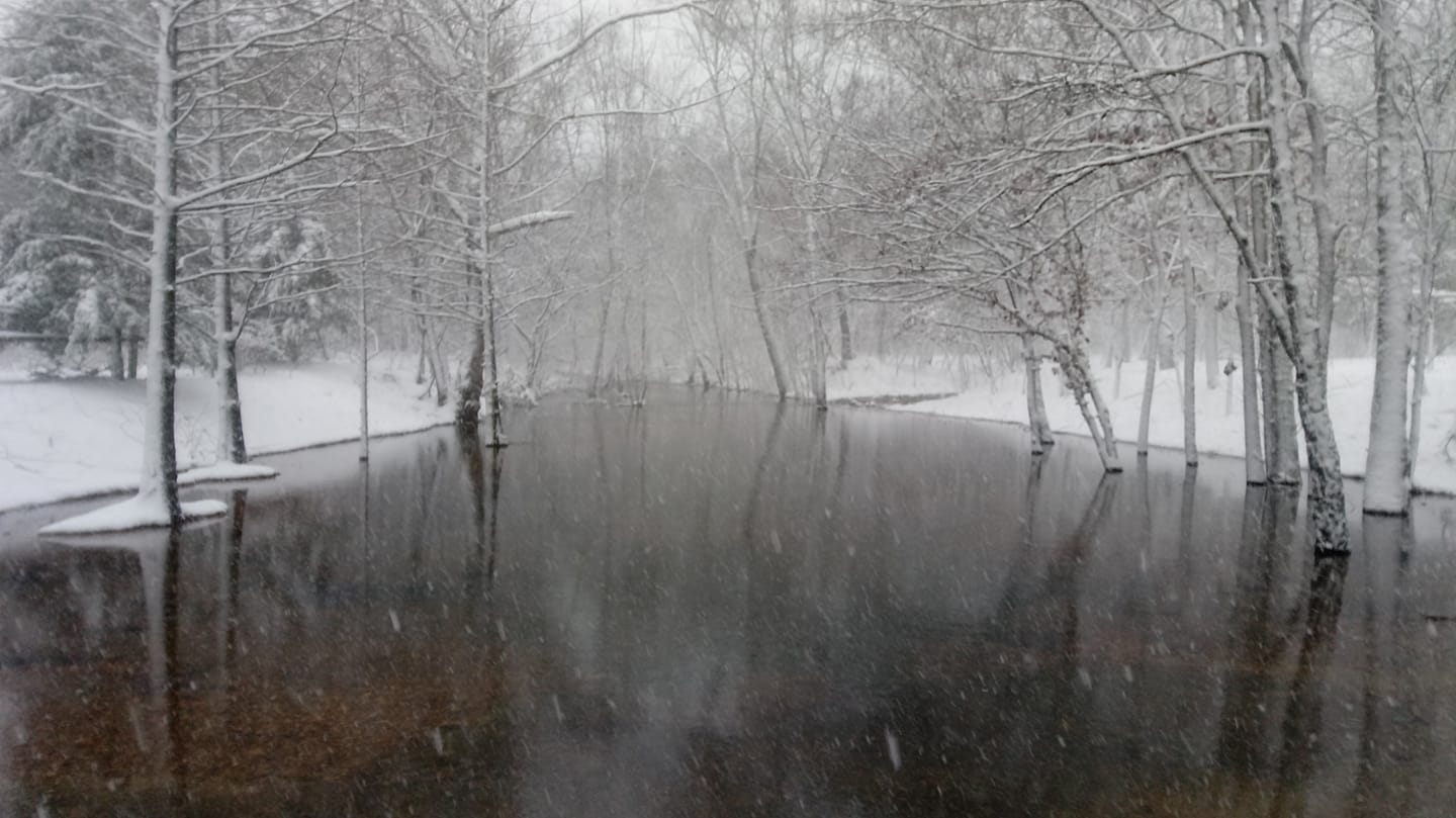
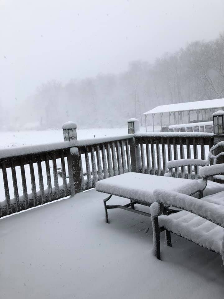
Photos
 |
 |
 |
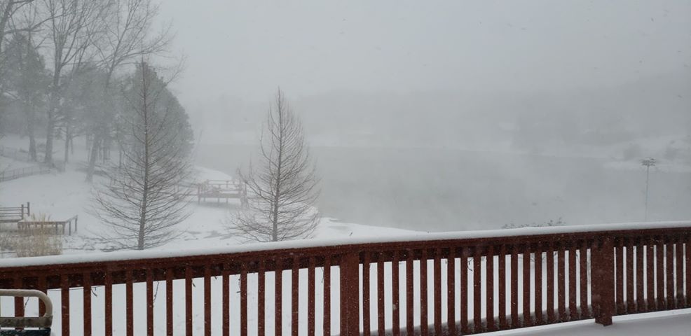 |
| Clinton, KY via Scott Smith | Du Quoin, IL via Guy Alongi | Evansville, IN via Sam Owens | Fruitland, MO via Jeff Gourd |
 |
 |
 |
 |
| Gipsy, MO via Rachel DiLeo Semmel | Marion, IL via Megan Thompson | Van Buren, MO via Melinda Hilton Christensen | Owensboro, KY via Chris Conley |
Storm Reports
Click here for an interactive map of snowfall reports.
PRELIMINARY LOCAL STORM REPORT...SUMMARY NATIONAL WEATHER SERVICE PADUCAH KY 1237 PM CST SUN JAN 20 2019 ..TIME... ...EVENT... ...CITY LOCATION... ...LAT.LON... ..DATE... ....MAG.... ..COUNTY LOCATION..ST.. ...SOURCE.... ..REMARKS.. 0100 PM SNOW VAN BUREN 37.00N 91.02W 01/19/2019 M2.5 INCH CARTER MO EMERGENCY MNGR REPORTS OF 2-3 INCHES HAVE FALLEN SO FAR IN VAN BUREN. 0102 PM SNOW ELLSINORE 36.93N 90.74W 01/19/2019 M3.0 INCH CARTER MO TRAINED SPOTTER 2.5 TO 3 INCHES AROUND ELLSINORE AREA SO FAR. STILL SNOWING HARD WITH BIG FLAKES AT TIME OF REPORT. 0107 PM SNOW GREENVILLE 37.13N 90.45W 01/19/2019 M1.0 INCH WAYNE MO EMERGENCY MNGR 0129 PM SNOW 5 W ELLSINORE 36.93N 90.84W 01/19/2019 M4.5 INCH CARTER MO TRAINED SPOTTER STILL SNOWING AT TIME OF REPORT. 0142 PM SNOW 2 E ELLSINORE 36.93N 90.71W 01/19/2019 M5.0 INCH CARTER MO TRAINED SPOTTER 0147 PM SNOW 7 SSW CHICOPEE 36.89N 91.03W 01/19/2019 M6.5 INCH CARTER MO TRAINED SPOTTER REPORTED IN TOWN OF EASTWOOD. 0148 PM SNOW PIEDMONT 37.15N 90.70W 01/19/2019 M2.0 INCH WAYNE MO EMERGENCY MNGR VISIBILITY OF ABOUT 50 YARDS. 0200 PM SNOW PIEDMONT 37.15N 90.70W 01/19/2019 E3.0 INCH WAYNE MO PUBLIC 0210 PM SNOW 3 W FARIDEALING 36.66N 90.68W 01/19/2019 M2.5 INCH RIPLEY MO TRAINED SPOTTER SNOW IS BLOWING AROUND WITH THE VISIBLITY LESS THAN 50 YARDS. 0210 PM SNOW ELLSINORE 36.93N 90.74W 01/19/2019 M6.5 INCH CARTER MO TRAINED SPOTTER VISIBILITY OF 50 TO 100 FEET. 0215 PM SNOW 9 S GREENVILLE 37.00N 90.45W 01/19/2019 M3.0 INCH WAYNE MO LAW ENFORCEMENT SNOW STILL COMING DOWN. ON HIGHWAY FF NEAR CAMP ALLEN. 0242 PM SNOW 1 E BARDLEY 36.69N 91.11W 01/19/2019 M8.0 INCH RIPLEY MO PUBLIC STILL SNOWING, VISIBILITY UNDER 0.25 MILE. NUMEROUS VEHICLES IN THE DITCH WEST OF DONIPHAN ALONG US 160. 0245 PM SNOW WOODLAWN 38.33N 89.04W 01/19/2019 M2.0 INCH JEFFERSON IL TRAINED SPOTTER SNOWING HEAVILY AT TIME OF REPORT. VISIBILITY ESTIMATED TO BE 1 TO 1.5 BLOCKS. 0253 PM SNOW HUNTER 36.89N 90.85W 01/19/2019 E9.0 INCH CARTER MO PUBLIC 0306 PM SNOW DE SOTO 37.81N 89.22W 01/19/2019 E1.0 INCH JACKSON IL PUBLIC BLIZZARD LIKE CONDITONS WITH MEASURED VISIBILITY AT 350 FEET. 0316 PM SNOW PIEDMONT 37.15N 90.70W 01/19/2019 E7.0 INCH WAYNE MO BROADCAST MEDIA 0341 PM SNOW CARBONDALE 37.73N 89.22W 01/19/2019 M2.0 INCH JACKSON IL TRAINED SPOTTER MEASURED ON THE SOUTH SIDE OF TOWN. 0342 PM SNOW 1 W BUCKNER 37.98N 89.04W 01/19/2019 E1.0 INCH FRANKLIN IL PUBLIC NEAR BLIZZARD CONDITIONS WITH VISIBILITY DOWN TO 100-200 YARDS AT TIMES. 0344 PM SNOW 2 W MARION 37.73N 88.97W 01/19/2019 M3.0 INCH WILLIAMSON IL TRAINED SPOTTER 0349 PM SNOW 2 E ELLSINORE 36.93N 90.71W 01/19/2019 E8.5 INCH CARTER MO PUBLIC FELL IN ABOUT 4 HOURS. 0355 PM SNOW MARION 37.73N 88.93W 01/19/2019 M4.0 INCH WILLIAMSON IL PUBLIC 0424 PM SNOW 9 S GREENVILLE 37.13N 90.45W 01/19/2019 M5.8 INCH WAYNE MO LAW ENFORCEMENT 0510 PM SNOW MOUNT CARMEL 38.42N 87.76W 01/19/2019 M2.1 INCH WABASH IL TRAINED SPOTTER 0535 PM SNOW CARMI 38.09N 88.17W 01/19/2019 E2.0 INCH WHITE IL PUBLIC 0544 PM SNOW DU QUOIN 38.00N 89.24W 01/19/2019 E5.0 INCH PERRY IL PUBLIC 0546 PM SNOW MARION 37.73N 88.94W 01/19/2019 M5.0 INCH WILLIAMSON IL TRAINED SPOTTER 0603 PM SNOW 2 WSW CARBONDALE 37.72N 89.25W 01/19/2019 M4.0 INCH JACKSON IL TRAINED SPOTTER 0615 PM SNOW 3 W CAMPBELL HILL 37.93N 89.61W 01/19/2019 E4.5 INCH JACKSON IL PUBLIC 0615 PM SNOW DE SOTO 37.82N 89.22W 01/19/2019 M4.0 INCH JACKSON IL PUBLIC STORM TOTAL SNOWFALL OF 4 INCHES WITH A THIN LAYER OF ICE UNDERNEATH. SIGNIFICANT DRIFTING OCCURRED. 0626 PM SNOW 1 W DEXTER 36.79N 89.97W 01/19/2019 E3.5 INCH STODDARD MO PUBLIC 0630 PM SNOW MOUNT CARMEL 38.42N 87.75W 01/19/2019 E5.5 INCH WABASH IL PUBLIC 0636 PM SNOW MT. VERNON 38.34N 88.80W 01/19/2019 E5.0 INCH JEFFERSON IL PUBLIC 0637 PM SNOW MARION 37.80N 89.00W 01/19/2019 E6.0 INCH WILLIAMSON IL PUBLIC 0706 PM SNOW AVA 37.89N 89.50W 01/19/2019 E5.5 INCH JACKSON IL PUBLIC 0708 PM SNOW MARION 37.74N 88.94W 01/19/2019 M8.5 INCH WILLIAMSON IL BROADCAST MEDIA 0713 PM SNOW 5 W EVANSVILLE 37.97N 87.64W 01/19/2019 E2.0 INCH VANDERBURGH IN PUBLIC 0714 PM SNOW CRAINVILLE 37.75N 89.06W 01/19/2019 E3.5 INCH WILLIAMSON IL PUBLIC 0722 PM SNOW 3 SE EVANSVILLE 37.96N 87.50W 01/19/2019 E2.0 INCH VANDERBURGH IN PUBLIC 0722 PM SNOW ALBION 38.37N 88.06W 01/19/2019 E5.0 INCH EDWARDS IL PUBLIC DRIFTING SNOW IS MAKING TRAVEL TOUGH. 0736 PM SNOW 1 WNW MARION 37.74N 88.96W 01/19/2019 E6.0 INCH WILLIAMSON IL PUBLIC 0739 PM SNOW DEXTER 36.79N 89.96W 01/19/2019 E3.1 INCH STODDARD MO PUBLIC 0746 PM SNOW FRUITLAND 37.45N 89.64W 01/19/2019 M5.7 INCH CAPE GIRARDEAU MO TRAINED SPOTTER 0746 PM SNOW 2 W JACKSON 37.39N 89.69W 01/19/2019 E4.0 INCH CAPE GIRARDEAU MO PUBLIC SNOWFALL HAS ENDED. AVERAGE OF SEVERAL MEASUREMENTS. DIFFICULT TO GET ACCURATE MEASUREMENT WITH BLOWING AND DRIFTING. 0747 PM SNOW PUXICO 36.96N 90.16W 01/19/2019 E3.5 INCH STODDARD MO PUBLIC 0748 PM SNOW CARBONDALE 37.73N 89.22W 01/19/2019 E4.0 INCH JACKSON IL PUBLIC 0749 PM SNOW THOMPSONVILLE 37.92N 88.76W 01/19/2019 M9.0 INCH FRANKLIN IL TRAINED SPOTTER 0750 PM SNOW ROSICLARE 37.43N 88.35W 01/19/2019 E2.0 INCH HARDIN IL PUBLIC 0751 PM SNOW LA CENTER 37.08N 88.97W 01/19/2019 M3.0 INCH BALLARD KY TRAINED SPOTTER 0759 PM SNOW 4 N WOODLAWN 38.39N 89.04W 01/19/2019 E3.0 INCH JEFFERSON IL PUBLIC 0800 PM SNOW PRINCETON 38.36N 87.57W 01/19/2019 E9.0 INCH GIBSON IN PUBLIC 0800 PM SNOW MCCLURE 37.32N 89.43W 01/19/2019 E3.5 INCH ALEXANDER IL PUBLIC 0801 PM SNOW NEW COLUMBIA 37.31N 88.78W 01/19/2019 E2.3 INCH MASSAC IL PUBLIC 0808 PM SNOW MOUND CITY 37.09N 89.16W 01/19/2019 E3.5 INCH PULASKI IL PUBLIC 0809 PM SNOW SESSER 38.09N 89.05W 01/19/2019 E7.0 INCH FRANKLIN IL PUBLIC 0810 PM SNOW ROBARDS 37.68N 87.55W 01/19/2019 E2.0 INCH HENDERSON KY PUBLIC 0816 PM SNOW ALTO PASS 37.58N 89.32W 01/19/2019 E4.5 INCH UNION IL PUBLIC 0817 PM SNOW OAKLAND CITY 38.35N 87.35W 01/19/2019 E6.5 INCH GIBSON IN PUBLIC 0819 PM SNOW 6 E WEST SALEM 38.52N 87.90W 01/19/2019 E4.0 INCH WABASH IL PUBLIC 0819 PM SNOW 2 E RALEIGH 37.83N 88.50W 01/19/2019 E3.3 INCH SALINE IL PUBLIC 0823 PM SNOW LONE OAK 37.04N 88.67W 01/19/2019 E2.1 INCH MCCRACKEN KY PUBLIC 0827 PM SNOW 4 NNW WARE 37.50N 89.43W 01/19/2019 E4.0 INCH UNION IL PUBLIC WOLF LAKE AREA. 0828 PM SNOW GIPSY 37.15N 90.18W 01/19/2019 E6.0 INCH BOLLINGER MO PUBLIC 0830 PM SNOW DAHLGREN 38.20N 88.68W 01/19/2019 E2.2 INCH HAMILTON IL PUBLIC STORM TOTAL. VERY WINDY. BLOWING AND DRIFTING OF FALLEN SNOW. SECONDARY ROADS VERY ICY AT THIS TIME. 0834 PM SNOW CALVERT CITY 37.04N 88.35W 01/19/2019 E2.5 INCH MARSHALL KY PUBLIC 0834 PM SNOW UNIONTOWN 37.78N 87.93W 01/19/2019 E2.5 INCH UNION KY PUBLIC 0835 PM SNOW ROSICLARE 37.43N 88.35W 01/19/2019 E3.0 INCH HARDIN IL TRAINED SPOTTER 0837 PM SNOW BERNIE 36.67N 89.97W 01/19/2019 E2.8 INCH STODDARD MO PUBLIC 0904 PM SNOW 1 WNW GRANDIN 36.83N 90.84W 01/19/2019 E7.3 INCH CARTER MO PUBLIC 0905 PM SNOW EDDYVILLE 37.08N 88.08W 01/19/2019 E2.0 INCH LYON KY PUBLIC 0907 PM SNOW CAPE GIRARDEAU 37.31N 89.55W 01/19/2019 E4.8 INCH CAPE GIRARDEAU MO PUBLIC 0909 PM SNOW CHRISTOPHER 37.98N 89.05W 01/19/2019 E4.0 INCH FRANKLIN IL PUBLIC 0916 PM SNOW 5 S STANLEY 37.76N 87.24W 01/19/2019 E1.0 INCH DAVIESS KY PUBLIC 0917 PM SNOW 1 ENE BENTON 36.86N 88.34W 01/19/2019 E2.0 INCH MARSHALL KY PUBLIC 0918 PM SNOW SEBREE 37.61N 87.53W 01/19/2019 E2.0 INCH WEBSTER KY PUBLIC 0920 PM SNOW ARLINGTON 36.79N 89.01W 01/19/2019 E1.0 INCH CARLISLE KY PUBLIC 0922 PM SNOW PRINCETON 37.11N 87.89W 01/19/2019 E2.0 INCH CALDWELL KY PUBLIC 0924 PM SNOW OWENSBORO 37.76N 87.12W 01/19/2019 E1.7 INCH DAVIESS KY PUBLIC 0930 PM SNOW 2 N MADISONVILLE 37.37N 87.51W 01/19/2019 E2.5 INCH HOPKINS KY PUBLIC 0933 PM SNOW 4 SSW NORTONVILLE 37.13N 87.48W 01/19/2019 E2.5 INCH CHRISTIAN KY PUBLIC CORRECTS PREVIOUS SNOW REPORT FROM 4 SSW NORTONVILLE. 0937 PM SNOW 1 WSW LONE OAK 37.03N 88.68W 01/19/2019 M1.5 INCH MCCRACKEN KY NWS EMPLOYEE 0938 PM SNOW PADUCAH 37.08N 88.64W 01/19/2019 M1.5 INCH MCCRACKEN KY NWS EMPLOYEE 0940 PM SNOW 4 SW BREWERS 36.74N 88.50W 01/19/2019 E2.5 INCH GRAVES KY PUBLIC 0942 PM SNOW 3 S CALVERT CITY 36.99N 88.35W 01/19/2019 E3.0 INCH MARSHALL KY PUBLIC 0945 PM SNOW MURRAY 36.62N 88.32W 01/19/2019 M1.5 INCH CALLOWAY KY TRAINED SPOTTER 0946 PM SNOW 1 N CARMI 38.10N 88.17W 01/19/2019 E4.0 INCH WHITE IL PUBLIC 0948 PM SNOW 1 NNW GORDONVILLE 37.32N 89.68W 01/19/2019 E2.0 INCH CAPE GIRARDEAU MO PUBLIC 1039 PM SNOW BERNIE 36.68N 89.97W 01/19/2019 E3.5 INCH STODDARD MO PUBLIC 1040 PM SNOW WEST FRANKFORT 37.90N 88.93W 01/19/2019 E4.5 INCH FRANKLIN IL PUBLIC 1041 PM SNOW HARDIN 36.77N 88.30W 01/19/2019 E2.5 INCH MARSHALL KY PUBLIC 1047 PM SNOW 7 SSW CHICOPEE 36.89N 91.03W 01/19/2019 E7.4 INCH CARTER MO PUBLIC 1103 PM SNOW CADIZ 36.87N 87.82W 01/19/2019 E3.0 INCH TRIGG KY PUBLIC 1104 PM SNOW PETERSBURG 38.49N 87.28W 01/19/2019 E7.0 INCH PIKE IN PUBLIC 1111 PM SNOW PRINCETON 37.11N 87.89W 01/19/2019 E3.0 INCH CALDWELL KY PUBLIC 1112 PM SNOW NORTONVILLE 37.19N 87.46W 01/19/2019 E3.0 INCH HOPKINS KY PUBLIC 1113 PM SNOW 4 NNW PENROD 37.16N 87.03W 01/19/2019 E2.0 INCH MUHLENBERG KY PUBLIC 1116 PM SNOW 4 S POSEYVILLE 38.11N 87.78W 01/19/2019 E2.0 INCH POSEY IN PUBLIC 1118 PM SNOW EDDYVILLE 37.08N 88.08W 01/19/2019 E2.5 INCH LYON KY PUBLIC 1135 PM SNOW 2 SE EVANSVILLE 37.97N 87.52W 01/19/2019 E2.2 INCH VANDERBURGH IN PUBLIC 1139 PM SNOW WINGO 36.64N 88.74W 01/19/2019 E3.0 INCH GRAVES KY PUBLIC 1140 PM SNOW 6 W PADUCAH 37.07N 88.76W 01/19/2019 M1.8 INCH MCCRACKEN KY OFFICIAL NWS OBS 1143 PM SNOW ROBARDS 37.68N 87.55W 01/19/2019 E2.0 INCH HENDERSON KY PUBLIC 1146 PM SNOW 2 W EVANSVILLE 37.99N 87.58W 01/19/2019 E2.5 INCH VANDERBURGH IN PUBLIC 1158 PM SNOW 1 WNW MELODY HILL 38.03N 87.54W 01/19/2019 M2.1 INCH VANDERBURGH IN FIRE DEPT/RESCUE 1200 AM SNOW GALATIA 37.84N 88.61W 01/20/2019 E8.0 INCH SALINE IL PUBLIC 1200 AM SNOW CARMI 38.09N 88.17W 01/20/2019 E6.0 INCH WHITE IL PUBLIC 1203 AM SNOW MOSELEYVILLE 37.67N 87.19W 01/20/2019 E3.0 INCH DAVIESS KY PUBLIC 1210 AM SNOW 4 WNW NEWBURGH 37.97N 87.46W 01/20/2019 E1.7 INCH VANDERBURGH IN PUBLIC 1222 AM SNOW 6 SW EVANSVILLE 37.95N 87.64W 01/20/2019 E3.0 INCH VANDERBURGH IN PUBLIC 1240 AM SNOW EAST PRAIRIE 36.78N 89.38W 01/20/2019 M2.0 INCH MISSISSIPPI MO TRAINED SPOTTER 0100 AM SNOW 5 S MARION 37.66N 88.94W 01/20/2019 M7.0 INCH WILLIAMSON IL TRAINED SPOTTER 0100 AM SNOW 3 ESE ROSEWOOD 37.08N 87.04W 01/20/2019 E3.5 INCH MUHLENBERG KY PUBLIC AVERAGE MEASUREMENT AT LAKE MALONE AREA. 0109 AM SNOW MORTONS GAP 37.24N 87.47W 01/20/2019 M3.5 INCH HOPKINS KY TRAINED SPOTTER 0205 AM SNOW OZARK 37.54N 88.76W 01/20/2019 E6.0 INCH JOHNSON IL PUBLIC 0500 AM SNOW 1 N BRIAR 36.66N 90.96W 01/20/2019 M3.9 INCH RIPLEY MO COCORAHS 0630 AM SNOW 8 NE MURRAY 36.69N 88.21W 01/20/2019 M2.0 INCH CALLOWAY KY TRAINED SPOTTER 0700 AM SNOW 2 SE CAPE GIRARDEAU 37.29N 89.52W 01/20/2019 M3.3 INCH CAPE GIRARDEAU MO COCORAHS 0700 AM SNOW 1 SW SANTA CLAUS 38.11N 86.94W 01/20/2019 M1.5 INCH SPENCER IN COCORAHS 0700 AM SNOW 5 WNW ELLSINORE 36.96N 90.83W 01/20/2019 M5.8 INCH CARTER MO COCORAHS 0700 AM SNOW 5 NW OAK GROVE 36.72N 87.49W 01/20/2019 M1.0 INCH CHRISTIAN KY COCORAHS 0700 AM SNOW 1 SSE COBDEN 37.52N 89.25W 01/20/2019 M2.8 INCH UNION IL COCORAHS 0700 AM SNOW 2 ENE NEW BURNSIDE 37.59N 88.74W 01/20/2019 M3.0 INCH JOHNSON IL COCORAHS 0700 AM SNOW 9 ESE STONEFORT 37.57N 88.56W 01/20/2019 M2.0 INCH POPE IL COCORAHS 0700 AM SNOW FRANCISCO 38.33N 87.45W 01/20/2019 M7.0 INCH GIBSON IN COCORAHS 0700 AM SNOW 2 N BOONVILLE 38.07N 87.27W 01/20/2019 M3.0 INCH WARRICK IN COCORAHS 0700 AM SNOW 3 NW POSEYVILLE 38.20N 87.82W 01/20/2019 M3.5 INCH POSEY IN COCORAHS 0715 AM SNOW MURRAY 36.61N 88.32W 01/20/2019 M1.8 INCH CALLOWAY KY CO-OP OBSERVER FINAL SNOWFALL TOTAL. 0800 AM SNOW 5 SSW MOUNT VERNON 38.25N 88.95W 01/20/2019 M3.5 INCH JEFFERSON IL COCORAHS 0900 AM SNOW 3 WNW SPOTTSVILLE 37.87N 87.46W 01/20/2019 E2.0 INCH HENDERSON KY PUBLIC NEAR BASKETT KY. 0900 AM SNOW HARRISBURG 37.74N 88.55W 01/20/2019 M3.0 INCH SALINE IL LAW ENFORCEMENT 0900 AM SNOW CARRIERS MILLS 37.69N 88.63W 01/20/2019 M3.0 INCH SALINE IL LAW ENFORCEMENT 0930 AM SNOW 5 W FULTON 36.51N 88.97W 01/20/2019 M1.5 INCH FULTON KY TRAINED SPOTTER 1000 AM SNOW JOHNSTON CITY 37.82N 88.93W 01/20/2019 M7.0 INCH WILLIAMSON IL PUBLIC 1030 AM SNOW CLIFTY 37.00N 87.15W 01/20/2019 M1.8 INCH TODD KY TRAINED SPOTTER AVERAGE SNOWFALL TOTAL IN CLIFTY, KY IS 1.75 INCHES. THERE IS A THIN LAYER OF ICE UNDER THE SNOW.
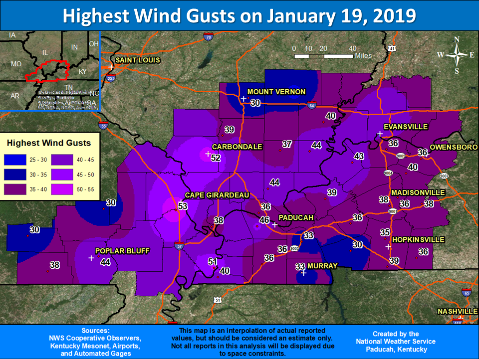
Highest Wind Gusts
As surface low pressure began to move east of the region, the pressure gradient really ramped up during the afternoon and evening hours, leading to winds increasing. Most locations experienced wind gusts of 35 to 45 mph, but there were some localized higher gusts. Cape Girardeau, MO observed 53 mph, Carbondale, IL observed 52 mph, and Paducah, KY observed 46 mph winds. The strong winds caused near-blizzard like conditions briefly during the afternoon and evening hours.
 |
Rain Reports
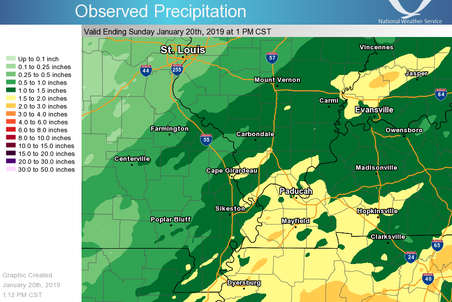
Heavy rain impacted the region during the first part of this event. Rainfall totals of 1 to 2 inches were common. This lead to standing water on some roadways while the rain was occurring. As temperatures rapidly plunged below freezing during the evening/overnight of the 19th, any residual moisture on surfaces flash froze. Some area rivers were also rising due to another round of rainfall.
 |
 |
Media use of NWS Web News Stories is encouraged! Please acknowledge the NWS as the source of any news information accessed from this site. |
|

