Overview
An outbreak of supercells occurred during the afternoon and evening of May 10, 2016. The strongest and longest-lived tornado of the day occurred in Graves and Marshall Counties of western Kentucky. In all, 9 tornadoes were confirmed in our forecast area, all of which touched down in either southern Illinois or western Kentucky.Tornadoes:
|
|
||||||||||
|
||||||||||
|
Tornado - MAYFIELD, KY area
Track Map 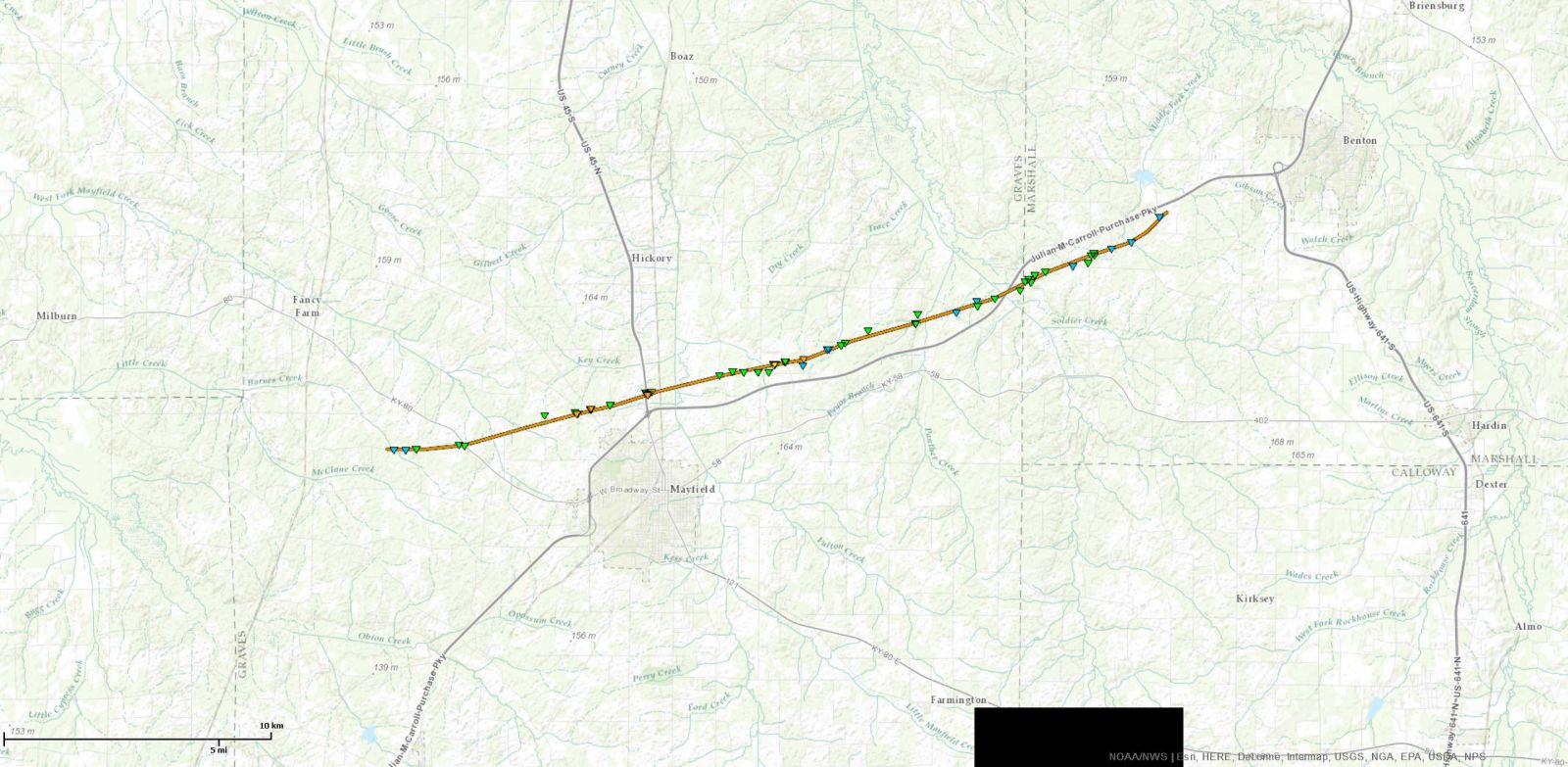 
|
||||||||||||||||
|
Tornado - Bancroft, KY area
Track Map 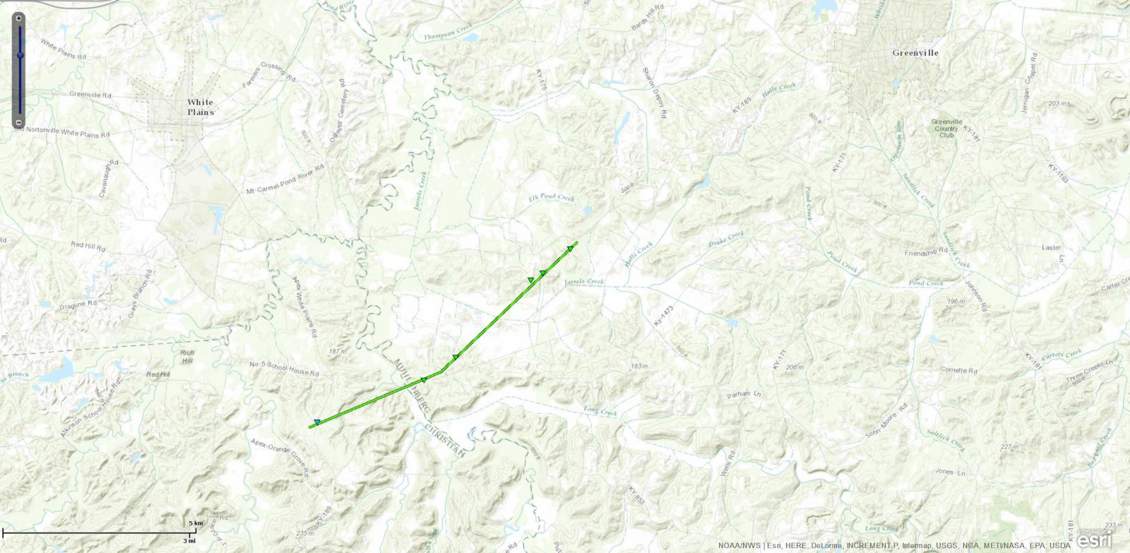 |
||||||||||||||||
|
Tornado - Cerulean, KY area
Track Map 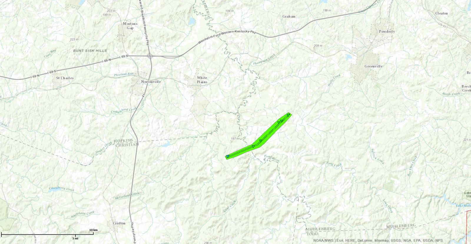
Other tornadoes:
All of the information on this page is preliminary. Final details will be contained in the Storm Data publication from the National Climatic Data Center. |
||||||||||||||||
The Enhanced Fujita (EF) Scale classifies tornadoes into the following categories:
| EF0 Weak 65-85 mph |
EF1 Moderate 86-110 mph |
EF2 Significant 111-135 mph |
EF3 Severe 136-165 mph |
EF4 Extreme 166-200 mph |
EF5 Catastrophic 200+ mph |
 |
|||||
Hail:
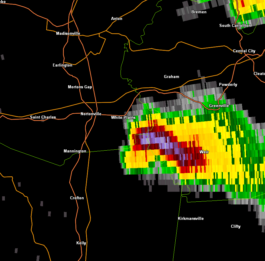
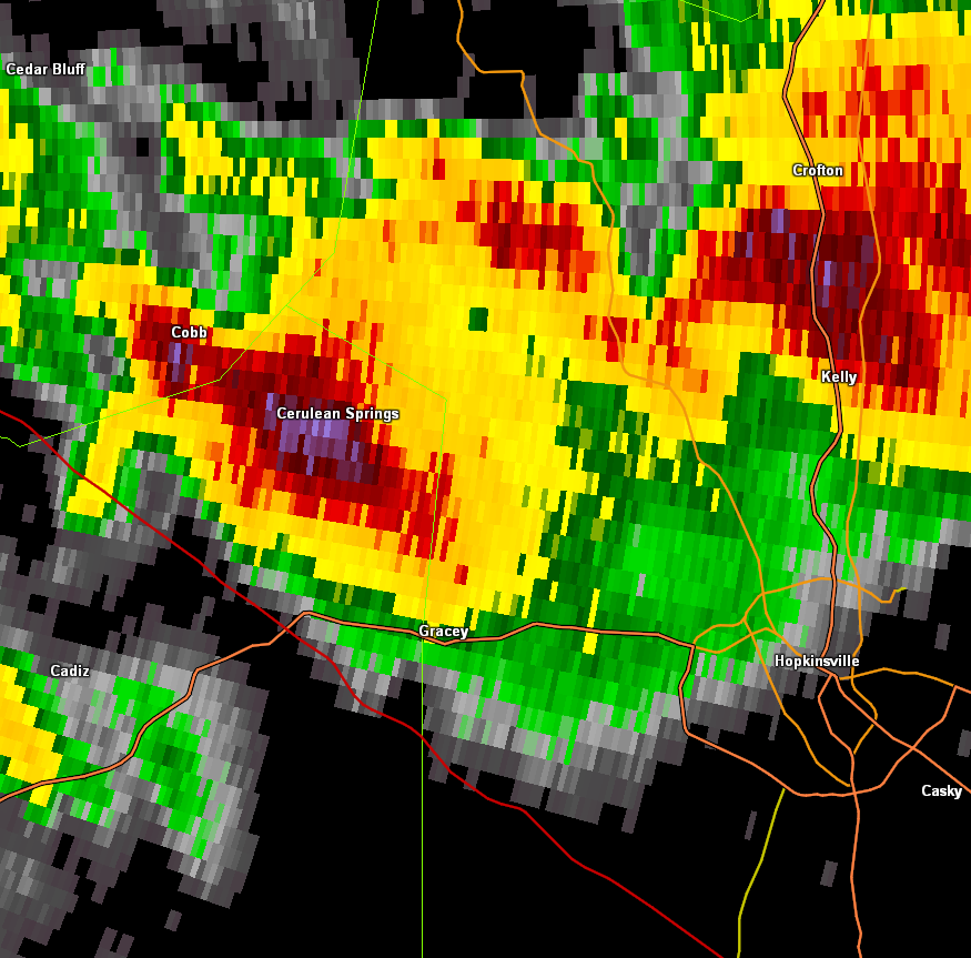
Large hail was observed with the supercells. Hailstones were larger than golf balls in some of the storms, beginning with the Owensboro, KY storm around 1 P.M. The storm that produced the EF-1 tornado near Bancroft in Muhlenberg County, KY also produced baseball-size hail about 5:30 P.M. The storm that produced the EF-0 tornado near Cerulean, KY also dropped hailstones about the size of baseballs. Finally, there were reports of quarter-size hailstones in Hopkinsville around 8:40 P.M., mainly on the northeast side of town.
Damaging straight-line winds were observed with a few storms. However, tornadoes and large hail were the main culprits behind most of the damage.
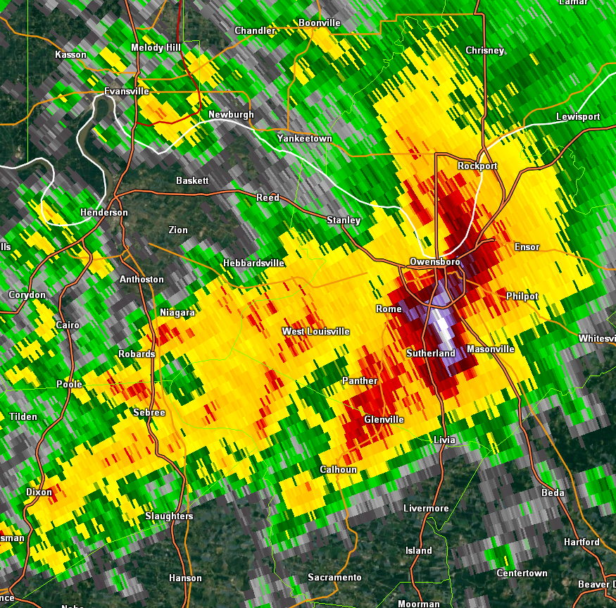
Hail
Radar imagery (using Gibson Ridge software) of the biggest hailstorms of the day...
 |
 |
 |
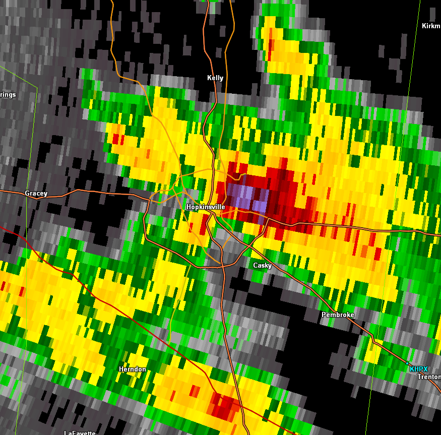 |
| Owensboro, KY hailstorm 1:05 P.M. | Muhlenberg Co. hailstorm 5:22 P.M. | Northeast Trigg Co hailstorm 7 P.M. | Hopkinsville hailstorm 8:43 P.M. |
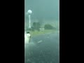
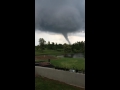
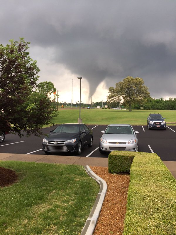
Photos & Video: Many eyewitnesses took photos and video of this tornado. The tornado passed through the north side of the city of Mayfield during the middle of the afternoon as some people were leaving school or work. The funnel was not rain-wrapped and was easily visible from a distance.
Videos: Video 1 was taken from Sullivan Road, several miles northwest of Mayfield. The tornado passed southeast and east of the videographer, Travis Willett. Click here for the full video.
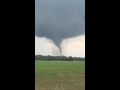
Video 2 was taken along U.S. Highway 45 near Mid-Continent University, a mile or two north of Mayfield. The tornado passed just south of the videographer. Click here for the full video.
Video 3 was taken in the Mayfield area by Justin Myers. Click here for the full video.
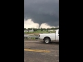
Video 4, which is over three minutes long, includes a hailstorm. The video was taken in the Mayfield area by Bobby Hamilton. Click here for the full video.
Damage photo 1... Location: West of Mayfield, less than one-half mile before the tornado crossed Highway 121. Damage rating: EF3. A truck was tossed about 150 yards. This was the first indication of EF3 damage along the tornado damage path.

Damage photo 2...EF3 damage to a large "flea market" type of business on Highway 121 just northwest of Mayfield.
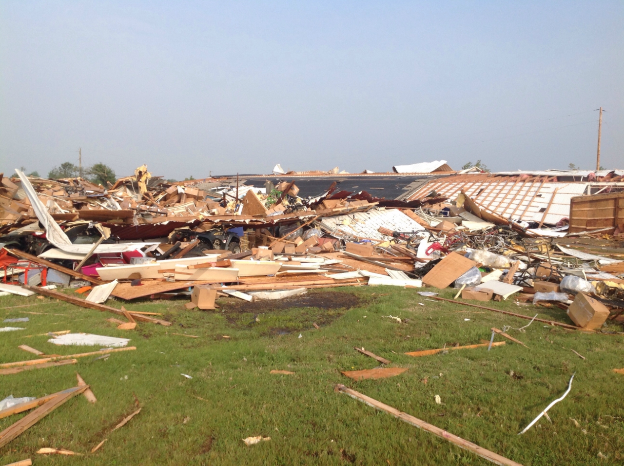
Damage photo 3...EF3 damage to vehicles at an auto dealership on U.S. Highway 45 near the northern city limit of Mayfield.

Damage photo 4...Location: Several miles northeast of Mayfield, just east of the interchange of the Purchase Parkway and Highway 131. Damage rating: EF3. Most of the second floor was removed from the home. A resident took shelter in an interior room on the lowest floor, which was the only room that remained intact. This was the last indication of EF3 damage along the track.
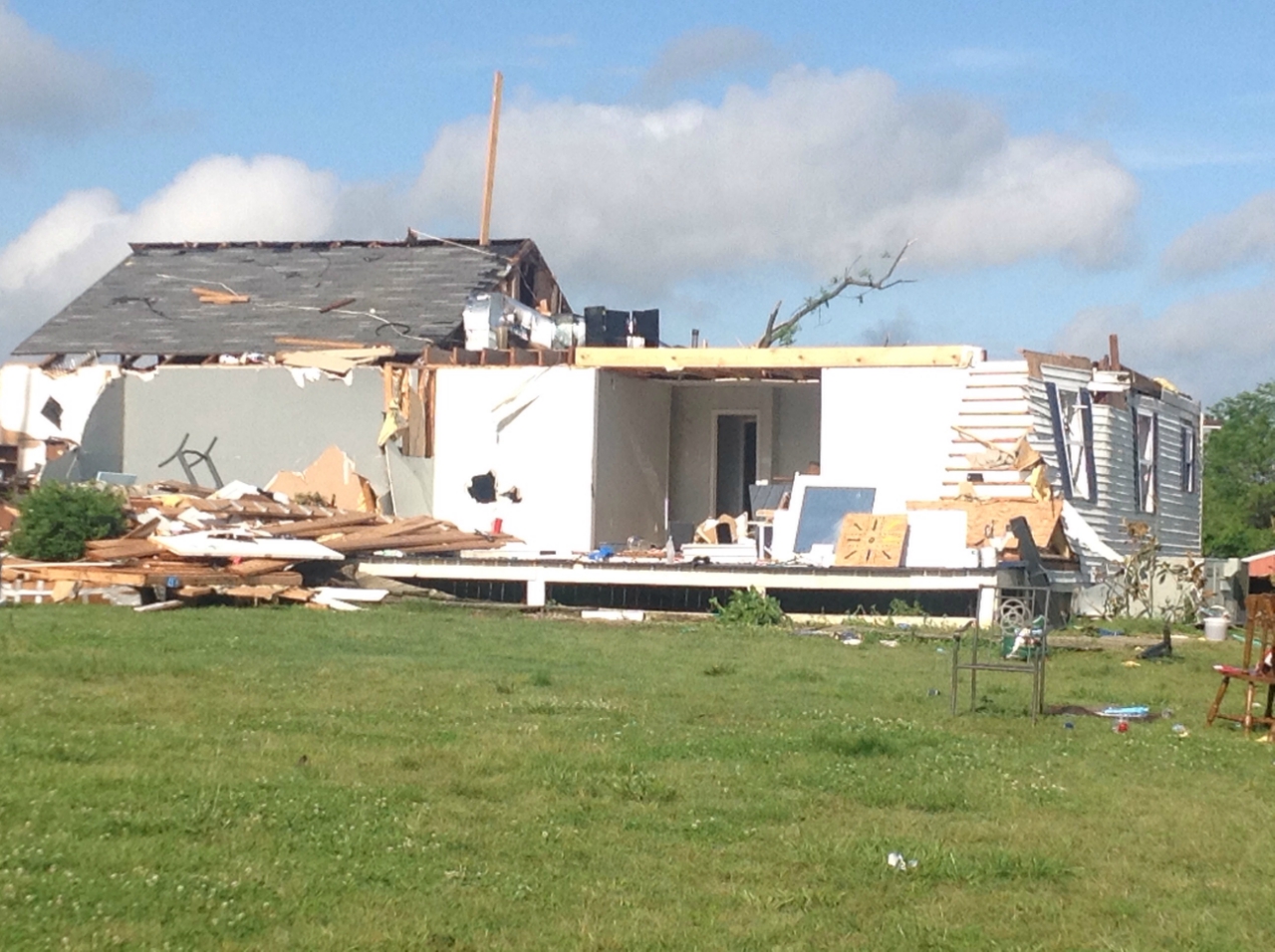
Photo below taken from the Purchase Area Development District office, which is on the south side of the Purchase Parkway interchange with Highway 121.
Radar:
Click here for a radar loop of this event
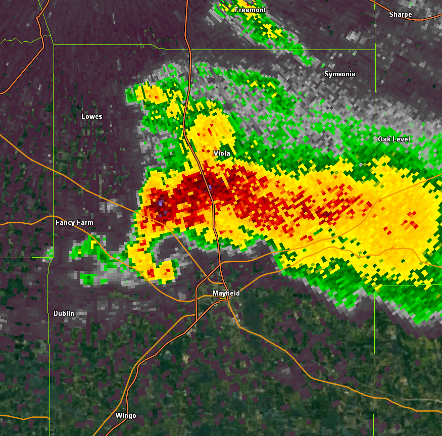
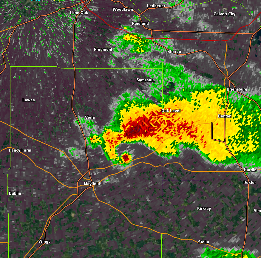
Reflectivity from the Paducah radar at 2:47 PM CDT as the tornado clipped the northwest edge of Mayfield. (Gibson Ridge software used for image).
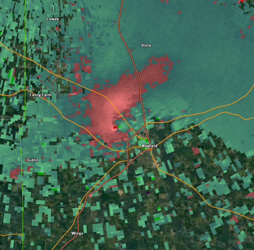
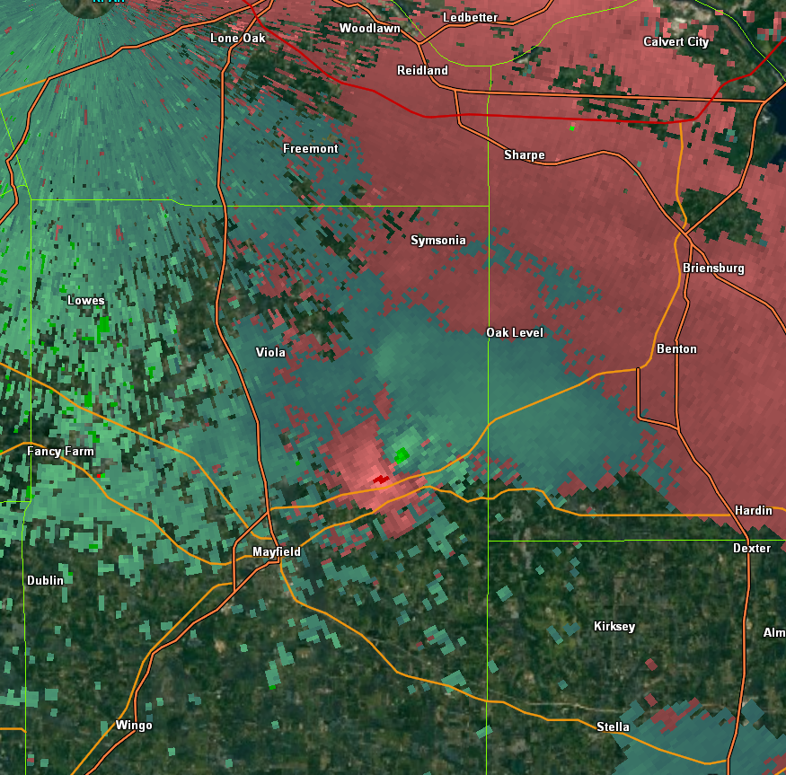
Storm-relative winds from the Paducah radar at 2:49 PM CDT as the tornado clipped northwest Mayfield. (Gibson Ridge software used for image).
Reflectivity from the Paducah radar at 3:02 PM CDT, shortly after the tornado hit the north edge of Mayfield. (Gibson Ridge software used for image).
Storm-relative winds from the Paducah radar at 3:02 PM CDT, shortly after the tornado left Mayfield. (Gibson Ridge software used for image).
Animation of radar imagery, focused on the Graves/Marshall County supercell:
 .
.
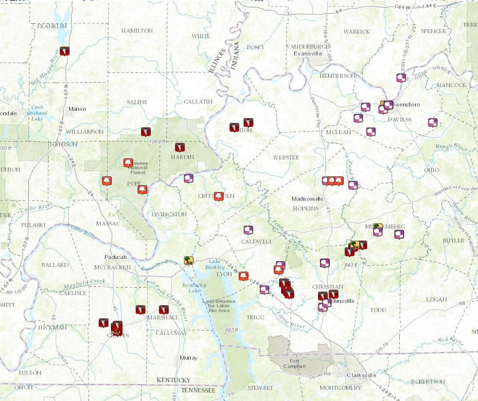
Preliminary Storm Reports
Map icons: purple-hail, red-tornado, orange-funnel cloud, yellow-wind
PRELIMINARY LOCAL STORM REPORT...SUMMARY
NATIONAL WEATHER SERVICE PADUCAH KY
1200 AM CDT WED MAY 11 2016
..TIME... ...EVENT... ...CITY LOCATION... ...LAT.LON...
..DATE... ....MAG.... ..COUNTY LOCATION..ST.. ...SOURCE....
..REMARKS..
1241 PM HAIL WEST LOUISVILLE 37.70N 87.29W
05/10/2016 E2.00 INCH DAVIESS KY PUBLIC
0100 PM TSTM WND GST 1 W OWENSBORO 37.76N 87.14W
05/10/2016 E60.00 MPH DAVIESS KY TRAINED SPOTTER
LOTS OF PEA SIZED HAIL ALONG WITH ESTIMATED 60 MPH WINDS.
0103 PM HAIL OWENSBORO 37.76N 87.12W
05/10/2016 M1.00 INCH DAVIESS KY TRAINED SPOTTER
ALSO REPORTED 55+ WINDS.
0103 PM HAIL 2 SW OWENSBORO 37.74N 87.15W
05/10/2016 M2.00 INCH DAVIESS KY TRAINED SPOTTER
0103 PM HAIL OWENSBORO 37.76N 87.12W
05/10/2016 E0.25 INCH DAVIESS KY TRAINED SPOTTER
PEA SIZED HAIL AT AIRPORT
0103 PM HAIL OWENSBORO 37.76N 87.12W
05/10/2016 M1.75 INCH DAVIESS KY TRAINED SPOTTER
0105 PM HAIL SORGHO 37.75N 87.25W
05/10/2016 E1.25 INCH DAVIESS KY PUBLIC
0106 PM HAIL ROCKPORT 37.88N 87.05W
05/10/2016 E0.50 INCH SPENCER IN TRAINED SPOTTER
PEA TO MARBLE SIZED HAIL, ALSO WHAT SEEMED LIKE A VERY
STRONG GUST OF WIND, POSSIBLE DOWNBURST.
0106 PM HAIL OWENSBORO 37.76N 87.12W
05/10/2016 E1.00 INCH DAVIESS KY TRAINED SPOTTER
QUARTER SIZED HAIL NEAR HWY 431
0111 PM HAIL OWENSBORO 37.76N 87.12W
05/10/2016 M1.00 INCH DAVIESS KY TRAINED SPOTTER
HAIL REPORTED ON THE EAST SIDE OF TOWN.
0120 PM HAIL PANTHER 37.64N 87.22W
05/10/2016 E1.75 INCH DAVIESS KY PUBLIC
ALONG HIGHWAY 81
0128 PM HAIL WHITESVILLE 37.68N 86.87W
05/10/2016 E1.00 INCH DAVIESS KY PUBLIC
0247 PM TORNADO 4 ENE FANCY FARM 36.78N 88.73W
05/10/2016 GRAVES KY TRAINED SPOTTER
0247 PM TORNADO MAYFIELD 36.74N 88.65W
05/10/2016 GRAVES KY LAW ENFORCEMENT
*** 8 INJ *** 8 NON LIFE-THREATENING INJURIES REPORTED BY
KY STATE POLICE.
0250 PM TSTM WND DMG 1 NW MAYFIELD 36.75N 88.66W
05/10/2016 GRAVES KY TRAINED SPOTTER
COLLAPSED BUILDING ON HWY 121 NORTH IN GRAVES COUNTY.
LIKELY TORNADO DAMAGE.
0251 PM TORNADO 2 NNW MAYFIELD 36.76N 88.66W
05/10/2016 GRAVES KY PUBLIC
TORNADO ON THE GROUND CROSSING HIGHWAY 121
0255 PM TORNADO 2 N MAYFIELD 36.77N 88.65W
05/10/2016 GRAVES KY NWS EMPLOYEE
TORNADO ON THE GROUND CROSSING HIGHWAY 45. DAMAGE/DEBRIS
HAVE BEEN CONFIRMED.
0306 PM TORNADO 10 NE MAYFIELD 36.84N 88.52W
05/10/2016 GRAVES KY TRAINED SPOTTER
TORNADO ON THE GROUND PRODUCING DAMAGE ON THE
GRAVES/MARSHALL COUNTY LINE.
0320 PM TORNADO 2 WSW BENTON 36.84N 88.39W
05/10/2016 MARSHALL KY TRAINED SPOTTER
TORNADO ON THE GROUND NEAR MILE MARKER 40 ON THE PURCHASE
PARKWAY.
0413 PM TSTM WND DMG 2 N LAKE CITY 37.06N 88.25W
05/10/2016 LIVINGSTON KY EMERGENCY MNGR
MANY TREES DOWN. DAMAGE TO CELL TOWERS. NEAR MM 34 ON
I-24/69.
0442 PM HAIL HANSON 37.42N 87.47W
05/10/2016 M0.75 INCH HOPKINS KY TRAINED SPOTTER
0446 PM FUNNEL CLOUD LAMASCO 36.99N 87.94W
05/10/2016 LYON KY TRAINED SPOTTER
0501 PM FUNNEL CLOUD CROFTON 37.05N 87.48W
05/10/2016 CHRISTIAN KY TRAINED SPOTTER
NEAR CROFTON
0503 PM HAIL CROFTON 37.05N 87.48W
05/10/2016 M1.00 INCH CHRISTIAN KY TRAINED SPOTTER
0504 PM FUNNEL CLOUD 2 E HANSON 37.42N 87.44W
05/10/2016 HOPKINS KY TRAINED SPOTTER
LOOKING EAST FROM I-69 HANSON EXIT
0504 PM FUNNEL CLOUD 2 E HANSON 37.42N 87.44W
05/10/2016 HOPKINS KY TRAINED SPOTTER
LOOKING EAST FROM HANSON EXIT I-69
0514 PM HAIL 3 WSW SACRAMENTO 37.40N 87.32W
05/10/2016 M1.50 INCH HOPKINS KY PUBLIC
0514 PM FUNNEL CLOUD 4 E HANSON 37.42N 87.40W
05/10/2016 HOPKINS KY EMERGENCY MNGR
0525 PM TORNADO 2 NE APEX 37.12N 87.32W
05/10/2016 MUHLENBERG KY 911 CALL CENTER
0526 PM TORNADO RUDEMENT 37.64N 88.49W
05/10/2016 SALINE IL PUBLIC
BRIEF TORNADO TOUCHDOWN.
0526 PM TORNADO 7 SW GREENVILLE 37.13N 87.27W
05/10/2016 MUHLENBERG KY 911 CALL CENTER
SIGNIFICANT DAMAGE TO HOUSE ON JOE ELI LANE ON
MUHLENBERG/CHRISTIAN CO. LINE. RESIDENT TOOK COVER IN A
STORM SHELTER.
0530 PM TORNADO APEX 37.10N 87.34W
05/10/2016 CHRISTIAN KY 911 CALL CENTER
EMS/EMA TRACKED TORNADO FROM FIRST TOUCHDOWN NEAR APEX TO
WEIR TO SOUTH OF DRAKESBORO NEAR BROWDER...THEN THE
TORNADO LIFTED AT APPROXIMATELY 555 PM. QUARTER TO LARGER
THAN GOLF BALL HAIL WAS REPORTED ALONG THE PATH.
0530 PM FUNNEL CLOUD EDDYVILLE 37.50N 88.59W
05/10/2016 POPE IL BROADCAST MEDIA
GROUND HUGGING WALL CLOUD SIGHTED.
0530 PM TSTM WND DMG 6 SE WHITE PLAINS 37.13N 87.31W
05/10/2016 MUHLENBERG KY EMERGENCY MNGR
SEVERAL BUILDINGS DAMAGED ALONG ELI LANE...5 BUILDINGS
DAMAGED ALONG JERRELLS CREEK ROAD...TREES UPROOTED AND
TWISTED IN THAT AREA. POWER POLES DOWN IN SW PART OF
COUNTY...WIDESPREAD HAIL DAMAGE WITHIN THE COUNTY...HAIL
UP TO SLIGHTLY LARGER THAN GOLF BALLS OCCURRED. EVENTS
OCCURRED BETWEEN 530 AND 600 PM.
0535 PM TSTM WND DMG GREENVILLE 37.21N 87.18W
05/10/2016 MUHLENBERG KY EMERGENCY MNGR
ROOF BLOWN OFF HOUSE ON TERRELLS CREEK ROAD SOUTH OF
GREENVILLE.
0536 PM FUNNEL CLOUD 3 NW DIXON SPRINGS 37.42N 88.71W
05/10/2016 POPE IL TRAINED SPOTTER
BRIEF TORNADO TOUCHDOWN LIKELY. DIFFICULT TO SEE BECAUSE
OF TREES.
0546 PM HAIL 1 S GREENVILLE 37.19N 87.18W
05/10/2016 M2.75 INCH MUHLENBERG KY TRAINED SPOTTER
0547 PM FUNNEL CLOUD 2 NW GOLCONDA 37.38N 88.51W
05/10/2016 POPE IL TRAINED SPOTTER
ROTATING WALL CLOUD SIGHTED.
0548 PM HAIL BEECH CREEK 37.18N 87.06W
05/10/2016 M1.00 INCH MUHLENBERG KY TRAINED SPOTTER
0549 PM HAIL BEECH CREEK 37.18N 87.06W
05/10/2016 M1.75 INCH MUHLENBERG KY BROADCAST MEDIA
TIME OF EVENT ESTIMATED.
0610 PM TORNADO MORGANFIELD 37.68N 87.91W
05/10/2016 UNION KY PUBLIC
0610 PM TORNADO W MORGANFIELD 37.68N 87.91W
05/10/2016 UNION KY TRAINED SPOTTER
BRIEF TORNADO TOUCHDOWN 1/2 MILE WEST OF MORGANFIELD
0624 PM HAIL 4 N CADIZ 36.93N 87.82W
05/10/2016 M0.75 INCH TRIGG KY TRAINED SPOTTER
0628 PM HAIL TOLU 37.43N 88.25W
05/10/2016 M1.00 INCH CRITTENDEN KY EMERGENCY MNGR
UP TO QUARTER SIZED HAIL.
0633 PM HAIL FARMERSVILLE 37.20N 87.91W
05/10/2016 E1.00 INCH CALDWELL KY PUBLIC
0638 PM HAIL 2 NE COBB 37.04N 87.73W
05/10/2016 M1.50 INCH CALDWELL KY TRAINED SPOTTER
0641 PM FUNNEL CLOUD 1 E COBB 37.02N 87.74W
05/10/2016 CALDWELL KY TRAINED SPOTTER
0645 PM FUNNEL CLOUD 1 N MARION 37.35N 88.08W
05/10/2016 CRITTENDEN KY TRAINED SPOTTER
ROTATING WALL CLOUD SIGHTED.
0700 PM HAIL CERULEAN 36.96N 87.71W
05/10/2016 M1.00 INCH TRIGG KY TRAINED SPOTTER
HAIL HAS BEEN OCCURRING FOR SEVEN MINUTES.
0703 PM HAIL CERULEAN 36.96N 87.71W
05/10/2016 M0.75 INCH TRIGG KY TRAINED SPOTTER
0705 PM HAIL CERULEAN 36.96N 87.71W
05/10/2016 M2.50 INCH TRIGG KY PUBLIC
0710 PM FUNNEL CLOUD CERULEAN 36.96N 87.71W
05/10/2016 TRIGG KY TRAINED SPOTTER
0716 PM TORNADO 2 SSE CERULEAN 36.93N 87.70W
05/10/2016 TRIGG KY LAW ENFORCEMENT
STRUCTURAL DAMAGE ALONG KY HIGHWAY 126 JUST NORTH OF
HIGHWAY 128.
0722 PM TORNADO BUFFALO 36.92N 87.69W
05/10/2016 TRIGG KY FIRE DEPT/RESCUE
TORNADO SIGHTED SOUTH OF CERULEAN IN THE BUFFALO AREA.
0724 PM TORNADO 1 SE CERULEAN 36.95N 87.70W
05/10/2016 TRIGG KY TRAINED SPOTTER
0725 PM TORNADO 4 SSE CERULEAN 36.91N 87.68W
05/10/2016 TRIGG KY LAW ENFORCEMENT
TROOPER SIGHTED TORNADO NEAR BUFFALO ROAD AND HIGHWAY
128. DAMAGE TO HOUSE REPORTED...OCCUPANTS FLED.
0727 PM TORNADO CERULEAN 36.96N 87.71W
05/10/2016 TRIGG KY EMERGENCY MNGR
DEBRIS SEEN ON GROUND.
0747 PM TORNADO 3 N HOPKINSVILLE 36.90N 87.49W
05/10/2016 CHRISTIAN KY TRAINED SPOTTER
TORNADO SIGHTED AT LAKE BLYTHE.
0803 PM TORNADO 5 NE HOPKINSVILLE 36.91N 87.43W
05/10/2016 CHRISTIAN KY TRAINED SPOTTER
REPORTED AT JOHNSON ROAD AND PILOT ROCK ROAD.
0837 PM HAIL HOPKINSVILLE 36.85N 87.49W
05/10/2016 M1.00 INCH CHRISTIAN KY TRAINED SPOTTER
0841 PM HAIL 2 NE HOPKINSVILLE 36.87N 87.47W
05/10/2016 M1.00 INCH CHRISTIAN KY TRAINED SPOTTER
Environment
The environment became supportive of supercells during the afternoon. With daytime heating, surface-based cape increased to nearly 3000 j/kg in the southwest corner of Kentucky by 21z. Deep-layer wind shear was sufficient for the initiation of supercells.
 |
 |
 |
| Figure 1: Surface-based cape 21z | Figure 2: 0-6 km bulk shear 21z | Figure 3: Significant Tor Parameter 21z |
Surface map and upper-air maps
 |
 |
 |
| Figure 4: Surface map 21z | Figure 5: 850 mb analysis 00z | Figure 6: 500 mb analysis 00z |
 |
Media use of NWS Web News Stories is encouraged! Please acknowledge the NWS as the source of any news information accessed from this site. |
|

