Springfield, MO
Weather Forecast Office
Overview
|
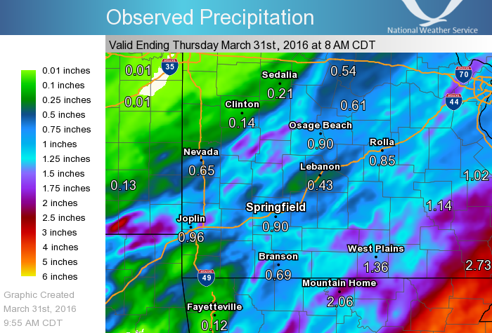
A series of thunderstorms brought heavy rain, along with some high winds and hail to the area from late morning on the 30th into the early morning hours on the 31st. The earlier convection which started during the late morning and continued into the afternoon hours, was mostly elevated in nature and produced mainly hail. Storms did not start to become surface based until forming along a dry line out in Kansas by early to mid afternoon, making it into southeast Kansas and the Missouri Ozarks during the evening and overnight hours. These surface based storms were the most severe out in Kansas and Oklahoma where tornadoes occurred, but did produce some wind damage in our area. |
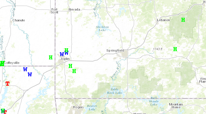 Storm Reports |
 |
Media use of NWS Web News Stories is encouraged! Please acknowledge the NWS as the source of any news information accessed from this site. |
|
Current Hazards
Experimental Graphical Hazardous Weather Outlook
Submit a storm report
Local Storm Reports
Current Conditions
Observations
Lake Levels
Snowfall Analysis
Road Conditions
Satellite
CoCoRaHS
Graphical Conditions
Precip. Analysis
Forecasts
Forecast Discussion
Fire Weather
Aviation
GIS Forecast Maps
Activity Planner
Severe Weather
Winter Weather
Hurricanes
FAA Center Weather
Space Weather
Climatology
Records and Normals
Monthly Climate Summary
Local
National
Drought
Climate Science
Astronomical Data
US Dept of Commerce
National Oceanic and Atmospheric Administration
National Weather Service
Springfield, MO
Springfield-Branson National Airport
5805 West Highway EE
Springfield, MO 65802-8430
Business: 417-863-8028 Recording: 417-869-4491
Comments? Questions? Please Contact Us.


 Weather Story
 Weather Map
 Local Radar