 |
Tornado Outbreak - Jan 7th-8th, 2008National Weather Service, Springfield, MO |
 |
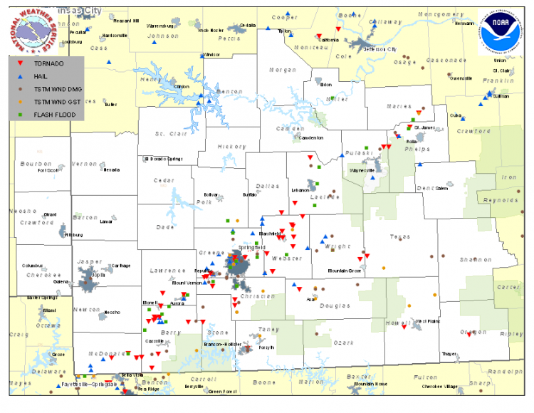
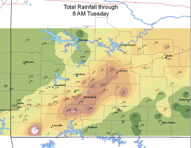
An unusually early severe weather outbreak hit the Missouri Ozarks Monday afternoon, January 7th, into the early morning hours Tuesday, January 8th, 2008. Numerous supercell thunderstorms spawned at least 33 tornadoes that resulted in significant damage to homes , trees and power lines. The supercell thunderstorms were followed by a violent squall line that produced damaging straight line winds in excess of 70 mph. In addition, the storms produced torrential rainfall and flash flooding. The storms developed as an intense storm system tracked out of the Rockies and interacted with an unseasonably warm, moist and unstable airmass across the Ozarks. National Weather Service Springfield, Missouri issued 33 severe thunderstorm warnings and 62 tornado warnings in approximately a 12 hour period. A total of 161 severe weather reports were received from mid afternoon on January 7th through the early morning hours on January 8th.
National Weather Service Springfield would like to thank emergency management, law enforcement , weather spotters and amateur radio operators, volunteer and cooperative observers, and radio and TV media for all of their reports and cooperation during this major severe weather event. Thank you for serving our community!
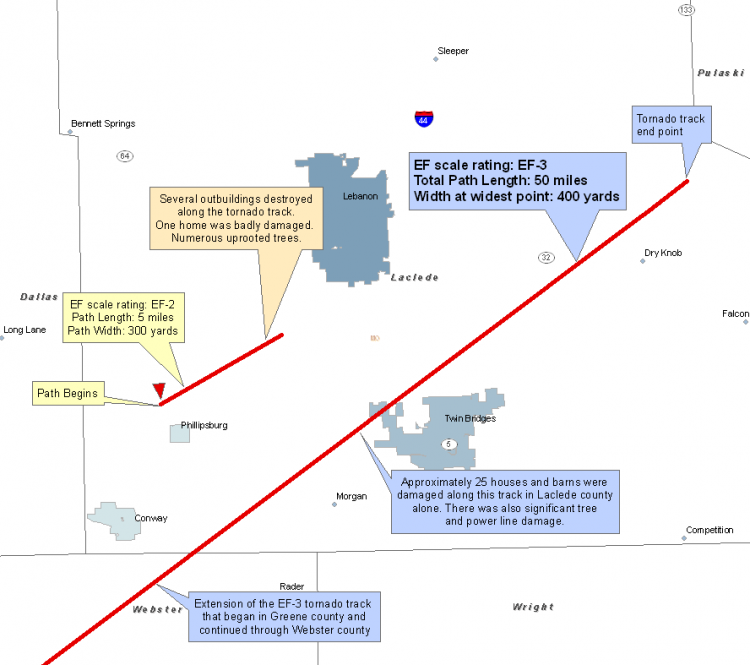
...EF-3 AND EF-2 TORNADOES IN EASTERN GREENE AND WEBSTER COUNTIES...
Based on a National Weather Service storm survey for the eastern Greene County and Webster County Tornado that began near Strafford Monday evening January 7, 2008 at approximately 6:25 PM. An EF-3 Tornado touched down three miles west of Strafford near the Junction of Farm Road 94 and 205 and moved northeast about 26 miles to about three miles south of Conway or one mile northeast of Sampson. This Tornado damaged or destroyed over 50 homes, mobile homes, barns, and outbuildings. Numerous large trees and power poles were uprooted or snapped off. One death occurred in a wood constructed home and a second death occurred in a mobile home with six injuries in homes and mobile homes.
Based on a second survey conducted for the eastern Greene County and Webster County Tornado that began east of Springfield Monday evening January 7, 2008 at approximately 7:35 PM. An EF-2 Tornado touched on Division or YY near Farm Road 205 and moved northeast about five to eight miles south of Strafford or just west of the Exotic Paradise Farm. Several homes, mobile homes and outbuildings were damaged or destroyed. Numerous trees and power poles were snapped off or uprooted.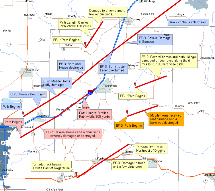
Republic to Springfield Tornadoes
...EF-1 TORNADO IN SOUTHERN GREENE COUNTY...A National Weather Service Storm survey team found that an EF-1 rated Tornado touched down just to the southwest of the city of Republic in Greene County Monday evening January 7, 2008 at approximately 6:00 PM. A brief touch down by a low end EF-1 Tornado with wind speeds near 94 MPH destroyed a well built pole barn. The path started four tenth of a mile west of Farm Road 57 and 188 and lifted a quarter mile east of the intersection.
...EF-2 TORNADO IN SOUTHERN GREENE COUNTY...
A National Weather Service Storm survey team found that an EF-2 rated Tornado touched down in the city of Republic in Greene County Monday evening January 7, 2008 at approximately 6:05 PM. An EF-2 Tornado with wind speeds near 125 MPH and a Damage path 75 yards wide and near two and half miles long affected northeastern portions of the city of Republic. The Tornado touched down near the Intersection of Farm Road 174 and College Ave and moved northeast lifting a quarter mile north of the intersection of Highway 60 and County Road MM.
...EF-1 TORNADO IN SPRINGFIELD IN GREENE COUNTY...
A National Weather Service Storm survey team found that an EF-1 rated Tornado touched down in the city of Springfield in Greene County early Tuesday morning January 8, 2008 at approximately 2:54 AM. An EF-1 Tornado touched down near the intersection of Sherman Road and Chestnut Expressway collapsing the metal building owned by the Harry S. Cooper Company. The Tornado continued on a 35 yard wide, intermittent path northeast producing 100 MPH winds and lifting one block north of the intersection of Chestnut Expressway and Glenstone Ave.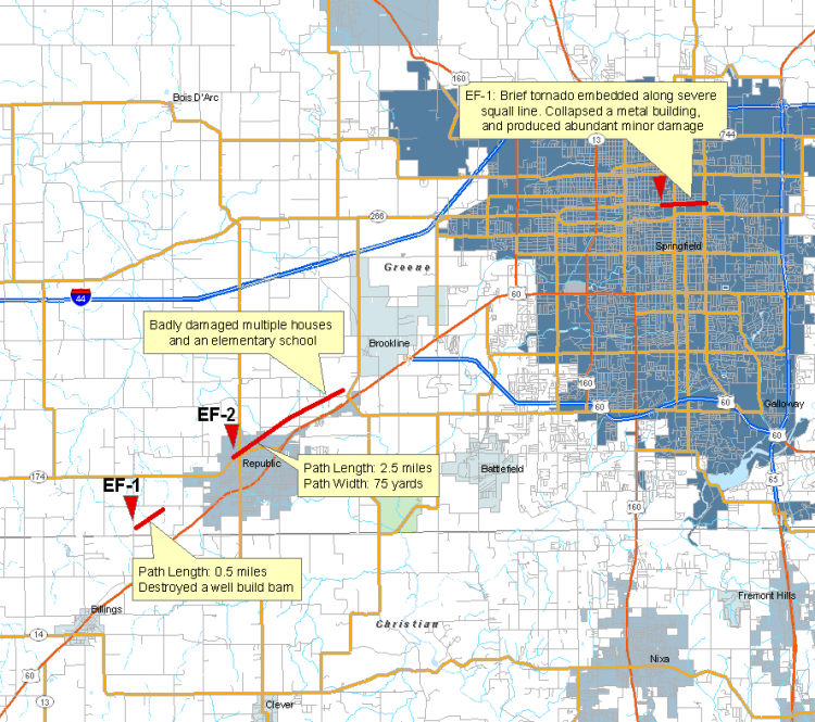
Barry & Lawrence County Tornadoes
A National Weather Service storm survey team found an EF-2 rated Tornado touched down in Barry county Monday evening January 7, 2008 at approximately 5:15 PM. An EF-2 Tornado touched down two miles northwest of Purdy and tracked northeast destroying a mobile home park at the intersection of Highways 37 and BB before lifting about four miles east of Monett around 5:25 PM. In addition to the mobile home park, a barn was destroyed, several homes sustained roof damage, and numerous trees were uprooted. Another survey will continue today for western Barry and MacDonald Counties.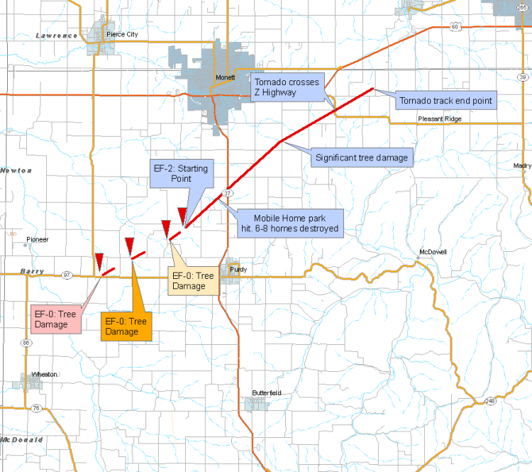
Vichy Tornado
...EF-1 Tornado in Maries County...
An EF-1 tornado tracked from 8 miles southwest of Vichy through the airport area to 4 miles northeast of Vichy. One mobile home destroyed
just northeast of the Vichy with one injury. 35 to 45 structures were damaged with a home partially moved off it's foundation and roof portions
thrown up to a quarter of a mile. Wind gusts tto 84 knots were recorded by the Vichy Automated Weather Station and damaged 3 airplanes at
the airport. The tornado toruched down at 942 PM and lifted at 10 PM. 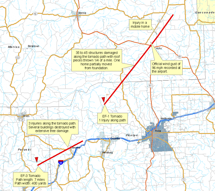
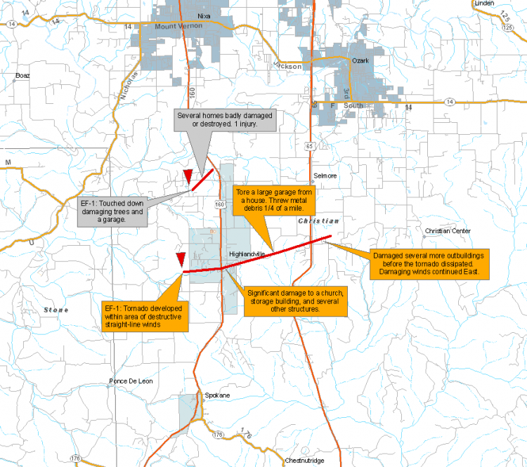
...EF-1  Tornadoes in Highlandville area in Christian County...

Two tornadoes touched down in the Highlandville area in western Christian County.
EF-1 tornado damaged several residences and destroyed two mobile homes. One mobile home resident was injured by the tornado. The path width was 100 yards at the widest point along its 1.5 mile path length and lasted for approximately 5 minutes. The tornado lifted near U.S. highway 160 3 miles north of Highlandville.
Another EF-1 tornado touched down 1.5 miles southwest of Highlandville and tracked east northeast through the town of Highlandville and lifted four miles east northeast of the city. This tornado damaged or destroyed numerous outbuildings along its 6 mile long track. The path was 200 yards wide at its widest point.
Douglas, Texas, and Wright County Tornado Tracks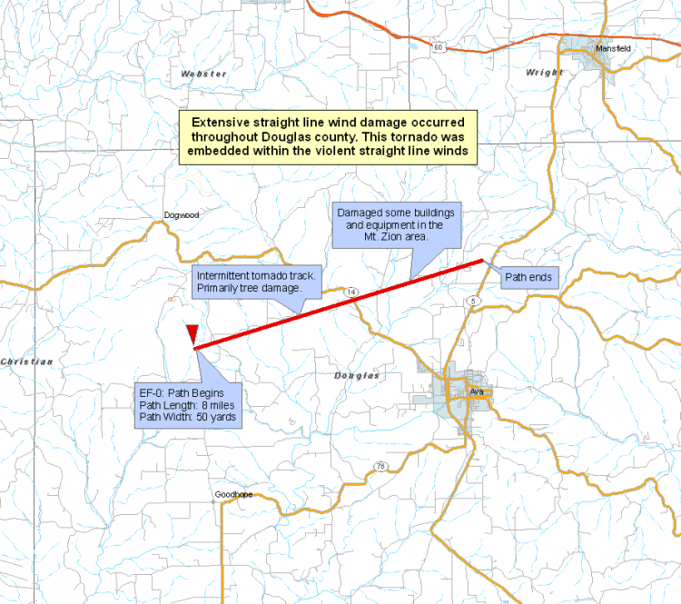
Stone County Tornado Tracks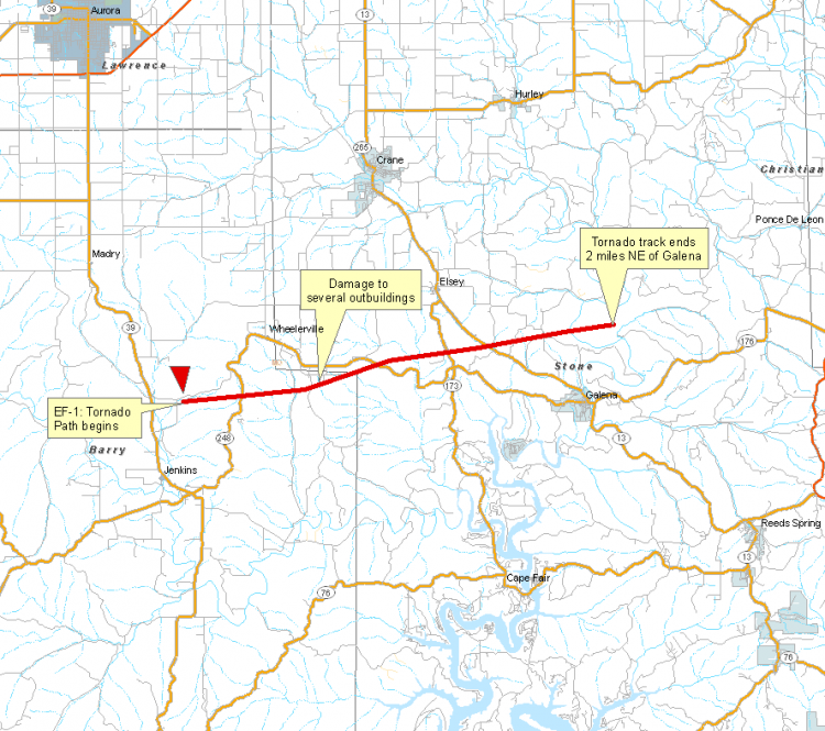
McDonald County Tornado
...EF-1 Tornado in Eastern McDonald County...
An EF-1 tornado tracked about 3 miles across eastern McDonald County or about 8 miles west of Washburn. The tornado path width was 75 yards
at it's widest point. The tornado lifted 7 buildings off of their foundations.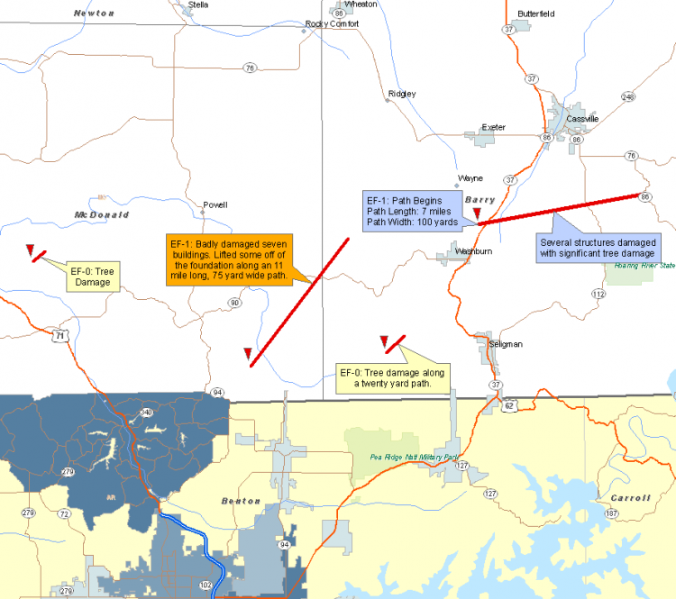
Shannon County Tornado Tracks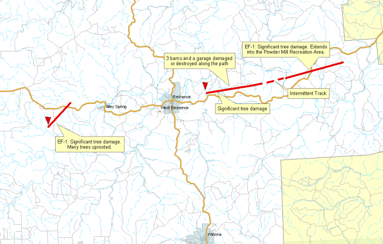


 Weather Story
 Weather Map
 Local Radar