 |
Severe Storms and Tornadoes - April 27th, 2014National Weather Service, Springfield, MO |
 |
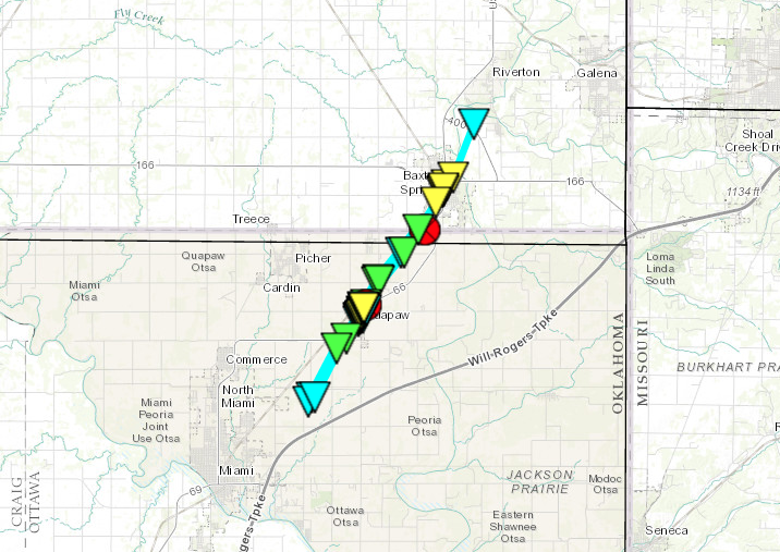
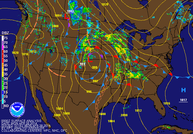
Event SummaryA strong slow moving storm moved into the Central Plains on Sunday. Initially strong to occasionally severe storms developed late Saturday night and Sunday from northeast Oklahoma and Kansas into parts of Missouri. Late Sunday afternoon, storms developed along a dryline over northeast Oklahoma and eastern Kansas and quickly became supercells. Confirmed tornadoes hit Baxter Springs, Kansas as well as an area near Fulton, Kansas northeast of Fort Scott. |
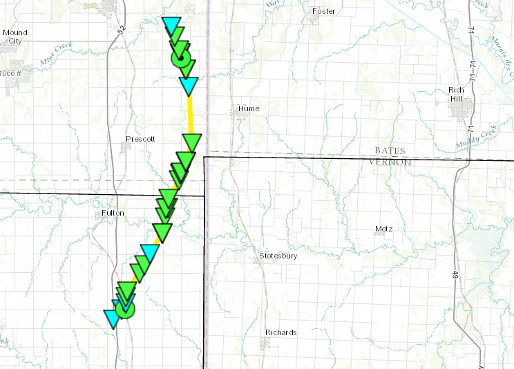
BOURBON AND LINN COUNTY TORNADO
RATING: EF-2
ESTIMATED PEAK WIND: 111-135 MPH
PATH LENGTH /STATUTE/: 17.0 MILES
PATH WIDTH /MAXIMUM/: 400 YARDS
FATALITIES: 0
INJURIES: 0
START DATE: APR 27, 2014
START TIME: 540 PM CDT
START LOCATION: 6 MILES NORTH OF FORT SCOTT, KANSAS
START LAT/LON 37.93 / -94.71
END DATE: APR 27, 2014
END TIME: 606 PM CDT
END LOCATION: 4 MILES EAST OF PLEASANTON, KANSAS
END LAT/LON: 38.16 / -94.65
THE NATIONAL WEATHER SERVICE IN PLEASANT HILL, MISSOURI CONDUCTED
A STORM SURVEY WHICH BEGAN IN BOURBON COUNTY, KANSAS AT THE
INTERSECTION OF HIGHWAY 69 AND SOLDIER ROAD, NEAR HAMMOND
KANSAS, WHERE VIDEO SUGGESTED THE TORNADO ORIGINALLY TOUCHED DOWN.
MINOR DAMAGE WAS NOTED NEAR HAMMOND, WITH THE MOST SIGNIFICANT
DAMAGE CONSISTING OF TOPPLED OVER GRAIN BINS AND SEVERAL DERAILED
EMPTY TRAIN CARS. THROUGH THE REMAINDER OF THE BOURBON COUNTY PATH
SEVERAL DESTROYED OUTBUILDINGS WERE NOTED AS WELL AS SIGNIFICANT
TREE DAMAGE.
THE MOST SIGNIFICANT DAMAGE OCCURRED AS THE TORNADO STRENGTHENED IN
LINN COUNTY KANSAS. IN RURAL LINN COUNTY, BETWEEN PLEASANTON AND
PRESCOTT, AN OUTDOOR GARAGE STORING HEAVY EQUIPMENT WAS COMPLETELY
DESTROYED AND NEARLY REMOVED FROM ITS FOUNDATION. AT THIS SAME
LOCATION AN EMPTY SEMI TRAILER WAS TOSSED OVER 200 YARDS INTO A
GROVE OF TREES AND SEVERAL OTHER SMALLER VEHICLES WERE TOSSED
ABOUT THE PROPERTY. NEAR PLEASANTON A CHURCH THAT WAS BUILT IN THE
1880`S WAS COMPLETELY DESTROYED. THE PATH OF THE TORNADO ENDED JUST
EAST/SOUTHEAST OF PLEASANTON IN AN OPEN FIELD.
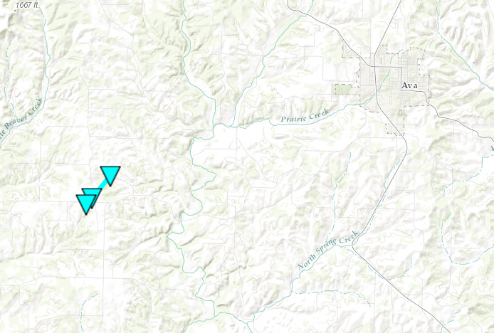
...EF-0 tornado confirmed in Douglas County...
* Date...April 27, 2014
* Begin Location...1/2 mile Southwest of Goodhope
* End Location...1/2 mile Northeast of Goodhope
* Estimated begin time...11:45 PM
* Estimated end time...11:50 PM
* MAXIMUM EF-SCALE RATING...EF-0
* Estimated maximum wind speed...80 mph
* Estimated path width...100 yards
* Path length...1 mile
* Fatalities...0
* Injuries...0
* Begin Lat/Lon...36.91 N / 92.81 W
* End Lat/Lon...36.92 N / 92.80 W
* This preliminary information was determined by a National
Weather Service Survey Team and is subject to change pending
final review of the event and publication in National Weather
Service Storm Data.
Additional information...
A NWS Storm Survey showed that a brief EF-0 tornado affected the
town of Goodhope. This tornado produced considerable tree damage
along a 1 mile path from just southwest of Goodhope the northeast
of Goodhope. Several outbuildings were also damaged. Winds were
estimated at 80 MPH.
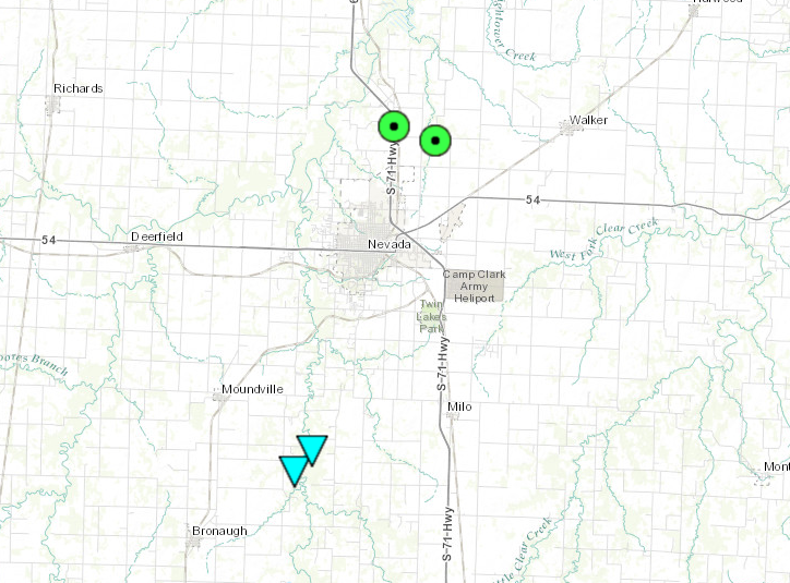
...EF-0 tornado confirmed in Vernon County...
* Date...April 27, 2014
* Begin Location...4.6 miles West of Milo
* End Location...4.3 miles West of Mile
* Estimated begin time...6:15 PM
* Estimated end time...6:16 PM
* MAXIMUM EF-SCALE RATING...EF-0
* Estimated maximum wind speed...70
* Estimated path width...100 yards
* Path length...1/4 mile
* Fatalities...0
* Injuries...0
* Begin Lat/Lon...37.73024 N / -94.39951 W
* End Lat/Lon...37.73383 N / -94.39526 W
* This preliminary information was determined by a National
Weather Service Survey Team and is subject to change pending
final review of the event and publication in National Weather
Service Storm Data.
Additional information...
Several reports from the public revealed a brief tornado touchdown
over rural and wooded land south of Nevada and west of Milo with
several trees and large branches blown down. One eye witness
captured the tornado on video and another witness captured a
detailed picture of the tornado on the ground. The land area where
trees were down was in an area that is remote and had no road
access. Time and location was estimated by witness and radar.
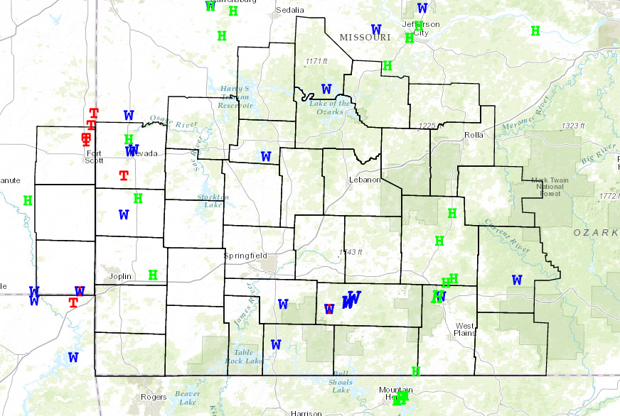


 Weather Story
 Weather Map
 Local Radar