National Weather Service United States Department of Commerce

Additional Heavy Rain and Flooding Concerns in Central Texas; Tropical Storm Chantal to Impact the Coastal Carolinas

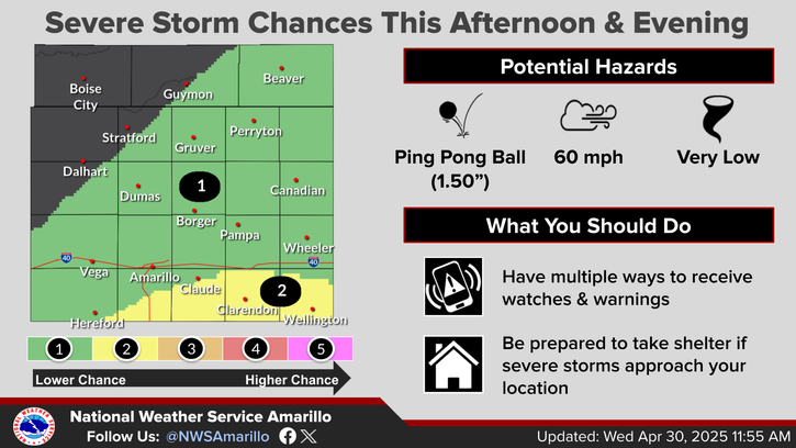
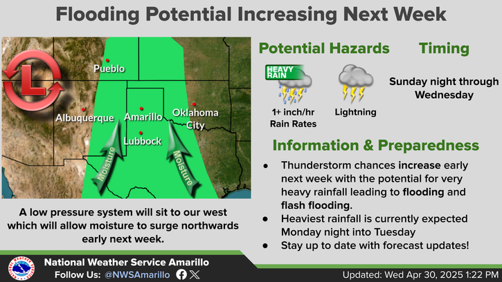
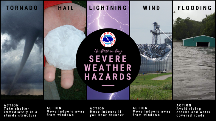
Heavy rainfall and flooding concerns remain for today across Central Texas and the Hill Country, with scattered thunderstorms expected this afternoon and evening. Tropical Storm Chantal has formed and will bring heavy rainfall and flooding concerns to portions of the coastal Carolinas. Life-threatening surf and rip currents are expected from the Southeast to Mid-Atlantic. Read More >

Click a location below for detailed forecast.

Last Map Update: Sat, Jul 5, 2025 at 2:50:11 pm CDT

Isolated to scattered thunderstorm are expected to develop late this afternoon and evening. The highest rain chances favor the northwest Panhandles, however storms may impact areas as far east as Amarillo to Borger, Perryton and Beaver. Any storms that form will produce dangerous lighting and heavy downpours. There is a low threat for severe thunderstorm impacts across the region associated with this activity today. The primary threat with any severe storms will be damaging winds up to 70 mph, but cannot rule out hail up to quarters as well.
There is a low probability (10-20%) for storms to develop along a weak boundary across the area as early as mid to late afternoon. A broken line of storms may also move into the Panhandles from New Mexico and this would likely will be the main concern for any severe storms later tonight. The line of storms should begin to dissipate and weaken by midnight tonight.
With high temperatures warming up into the upper 80s to mid 90s this afternoon combined with humid conditions, heat index or feels like temperature values will be a few degrees above the air temperature outside. These hot and humid conditions may lead to heat illnesses, so be sure to take proper precautions such as staying hydrated if you plan to be outside today!
The entire Texas and Oklahoma Panhandles has a low chance for severe storms on Sunday. A few rounds of storms are possible so the severe storm threat may last into Sunday night across portions of the area. The primary concern will once again be damaging wind gusts and a lesser threat for large hail. Any storms that form may also have heavy rain in addition to the severe storm threat.
With the feels like temperature values being in the 90s to just over 100 for some areas this weekend, be sure to keep heat safety in mind with any outdoor activities this Independence Day weekend.

Text Product Selector (Selected product opens in current window)


Current Observations ( )
Location Sky/Weather Temp (°F) Dewpt (°F) RH (%) Wind (mph) Pressure (inHg) Remarks
 Amarillo
N/A
N/A
N/A
N/A
N/A
N/A
N/A
 Borger
N/A
N/A
N/A
N/A
N/A
N/A
N/A
 Canadian
N/A
N/A
N/A
N/A
N/A
N/A
N/A
 Dalhart
N/A
N/A
N/A
N/A
N/A
N/A
N/A
 Dumas
N/A
N/A
N/A
N/A
N/A
N/A
N/A
 Guymon
N/A
N/A
N/A
N/A
N/A
N/A
N/A
 Hereford
N/A
N/A
N/A
N/A
N/A
N/A
N/A
 Pampa
N/A
N/A
N/A
N/A
N/A
N/A
N/A
 Perryton
N/A
N/A
N/A
N/A
N/A
N/A
N/A
 Amarillo 9NNE
N/A
N/A
N/A
N/A
N/A
N/A
N/A
 Amarillo 7SSE
N/A
N/A
N/A
N/A
N/A
N/A
N/A
 Bootleg 11WNW
N/A
N/A
N/A
N/A
N/A
N/A
N/A
 Canadian 6E
N/A
N/A
N/A
N/A
N/A
N/A
N/A
 Clarendon 2WSW
N/A
N/A
N/A
N/A
N/A
N/A
N/A
 Claude 12SW
N/A
N/A
N/A
N/A
N/A
N/A
N/A
 Hereford 2NW
N/A
N/A
N/A
N/A
N/A
N/A
N/A
 McLean 1E
N/A
N/A
N/A
N/A
N/A
N/A
N/A
 Palo Duro SP
N/A
N/A
N/A
N/A
N/A
N/A
N/A
 Pampa 2E
N/A
N/A
N/A
N/A
N/A
N/A
N/A
 Umbarger 3NNE
N/A
N/A
N/A
N/A
N/A
N/A
N/A
Note: "N/A" or "MISG" will be displayed if values are not available. In the LOCATION column, click on links for a list of recent observations at sites of interest. In the WIND column, VRB is "variable" and G is "gust". In the REMARKS column, HX is "heat index", WCI is "wind chill index", and VSB is "visibility" (if shown).


Aviation Drought Fire Weather Hydrology Severe Weather Winter Weather
 
Climate Graphs Hourly Forecast Long Range Local Model Data Precip Maps Office Webcam
 
Education Local Research News Skywarn Weather Calculator Weather Radio