 |
|||||||||||||||||||||||||||||||||||||||||||||||||||||||||||||||||||||
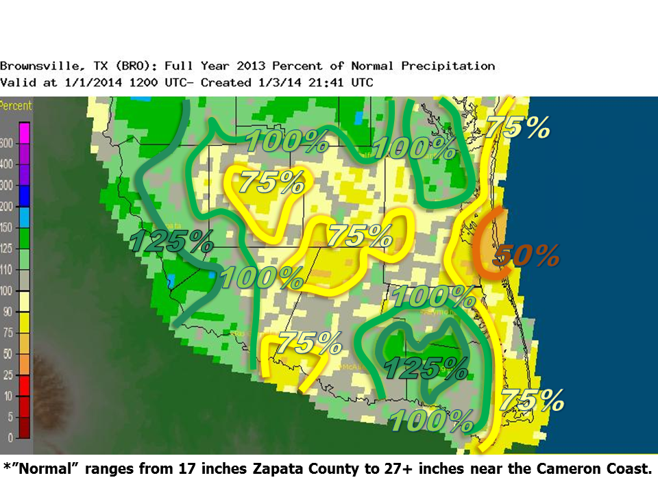 2013 Rio Grande Valley Percent Departure from Average Rainfall. |
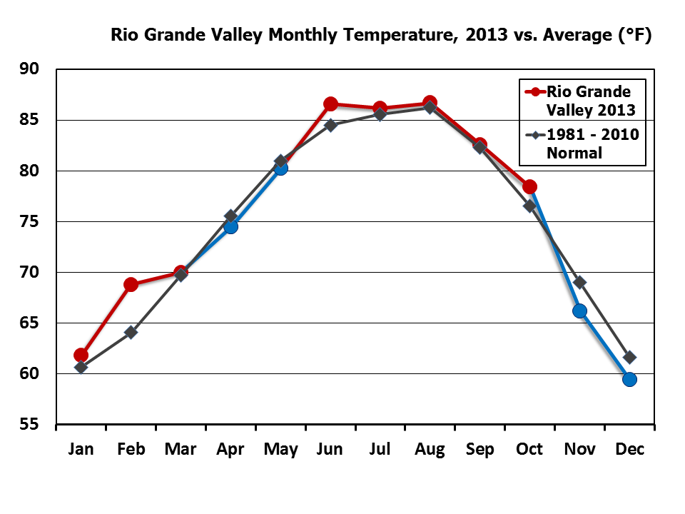 2013 Rio Grande Valley monthly average temperatures (circles) vs. the 1981-2010 30 year average (diamonds). Blue circles and lines indicate months with below average values; red circles/lines indicate above average values. |
||||||||||||||||||||||||||||||||||||||||||||||||||||||||||||||||||||
|
|||||||||||||||||||||||||||||||||||||||||||||||||||||||||||||||||||||
| The Year of Increasing Drought Relief 2013: Worsening Drought Early, Welcome Rain and Cooler Temperatures Late Water Emergency Averted by Autumn Rains, but Local Crises Continued |
|||||||||||||||||||||||||||||||||||||||||||||||||||||||||||||||||||||
|
In Brief Continue reading for a capsule of the many weather stories through 2013. Links are provided to take you to the full details of each event. |
|||||||||||||||||||||||||||||||||||||||||||||||||||||||||||||||||||||
| January to March: Dry and Dusty; Water Crises Begin | |||||||||||||||||||||||||||||||||||||||||||||||||||||||||||||||||||||
|
January began with a roller coaster of temperature, along with notable rainfall during the second week of the month which brought some hope to local farmers and ranchers. "Local" was the critical word; the heaviest rainfall covered a small stripe of Cameron and Willacy County; lower values up to one half of average (around an inch) dominated the remainder of the Valley and much of the ranchlands and combined with the warm finish to the month to set the stage for February. February ended up among the top ten warmest and driest across the region and by month’s end, Extreme to Exceptional Drought covered the area. The month was capped, appropriately, but a windy and dry front on February 25th which brought 35 to 50 mph wind gusts from the northwest, afternoon humidity below 10 percent, and visibilities briefly below 1 mile near and across unplanted fields. Additional lofted dust from west Texas settled in the Valley on the 26th and worsened air quality. March continued the dry trend, punctuated by just enough fronts to keep temperatures close to the long term average. Unfortunately, the fronts came through dry, save for one dying severe thunderstorm that dropped large hail in Falfurrias. Otherwise, all areas but the Lower Valley were rain free, and drought worsened. The dry atmosphere and cracked ground aided routinely low afternoon humidity; nearly one quarter of all days saw humidity ≤15 percent for the agricultural rich Valley; more than 33 percent of afternoons had ≤15 percent humidity across the Upper Valley and Rio Grande Plains/Ranchland region. By month’s end, Exceptional Drought covered all but Cameron and eastern Willacy County and a sliver of Zapata and Jim Hogg County. Though temperatures were close to the 1981–2010 average, March 2013 marked the 26th consecutive month above the average at Brownsville. |
|||||||||||||||||||||||||||||||||||||||||||||||||||||||||||||||||||||
| April to June: Some Rain Arrives | |||||||||||||||||||||||||||||||||||||||||||||||||||||||||||||||||||||
|
April continued the ’roller coaster’ of above and below average temperatures through mid month, courtesy of continued fast flow in the atmosphere that brought frequent but still dry fronts. A particularly strong system swept through the Valley on the 18th, turning 100° swelter into early spring chill the following morning; this system set the table for what would be the first area–wide below average month in more than three years! Brownsville snapped a 25 month string, and McAllen ended a 36 of 37 month stretch. The month was punctuated by one of the few notable severe weather events, one that brought more than two inches of rain, lightning strikes, and some damaging wind gusts mainly east of U.S. 281/IH 69C in Hidalgo and Cameron County. The spring to summer transition that occurs in May usually comes with at least one notable weather event, especially during the first half of the month. 2012 was filled with locally hazardous weather in the form of hail, wind gusts, and a few tornadoes. 2013 was less noisy, but an active weather pattern high in the atmosphere between May 10th and 15th brought welcome thunderstorms to the favored locations east of the Sierra Madre Oriental during the evening of the 10th and toward the Lower Valley coast early on the 11th. A second disturbance brought steady rains to the Valley overnight on the 11th and 12th, and a final weather maker brought showers and thunderstorms to the Rio Grande Plains and northern ranchlands on the 13th and 14th. Thereafter, hot and rain free weather took control to close out the month. The transition to summer was over by June, as hot temperatures and below average rainfall dominated the month. The summer feel was aided by the early development of "La Canícula", the persistent ridge of high pressure that typically forms over northwest Mexico in July and August. One quick–hitting microburst slammed the Weslaco–Mercedes area on June 3rd, leaving up to $100 thousand and damage in its wake. Another individual storm on June 7th caused minor damage to trees and power lines in Mission. The dry weather across the Valley came with one silver lining. Around mid June, an upper level disturbance temporarily dented the Canícula ridge in west Texas; a surge of tropical moisture fed toward the lee of Sierra Madre and ultimately produced up to 17 inches of rain near Eagle Pass. This rain flowed into the Rio Grande and provided a small but welcome boost the Falcon International Reservoir toward month's end. To Page 2 |
|||||||||||||||||||||||||||||||||||||||||||||||||||||||||||||||||||||

