The Year of Increasing Drought Relief 2013: Worsening Drought Early, Welcome Rain and Cooler Temperatures Late Water Emergency Averted by Autumn Rains, but Local Crises Continued |
|||||||||||||||||||||||||||||||||||||||||||||||||||||||||||
 |
 |
||||||||||||||||||||||||||||||||||||||||||||||||||||||||||
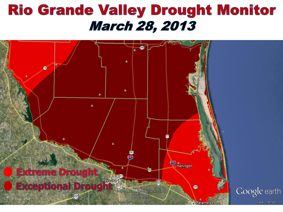
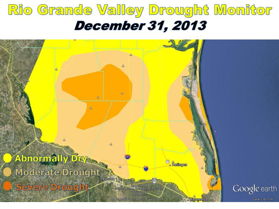
| Above: Drought monitor improvement from late March to late December 2013. Click to enlarge. Details on drought classification can be found here. | |||||||||||||||||||||||||||||||||||||||||||||||||||||||||||
| July to September: Seasonable Heat Early Turns to Wetness Late | |||||||||||||||||||||||||||||||||||||||||||||||||||||||||||
|
July and August were relatively nondescript summer months across the Rio Grande Valley and the Deep South Texas ranchlands. Despite the relative quietude, one significant event in late July provided more help to Rio Grande Basin reservoirs; this time, Amistad received the benefit. Ten to twenty inches of rain fell in the Rio Conchos basin of north central Mexico between the 17th and 21st; much of that rain filled reservoirs in Chihuahua State, Mexico and excess was released into the Rio Conchos. This water reached the Rio Grande and would begin to increase levels at Amistad, which was the start of a welcome trend that would continue through autumn. August began hot and dry and was bringing fears for a return of worsening drought once again, similar to 2012 and 2011. Then, a subtle pattern change allowed an influx of subtropical moisture to slide into South Texas which lowered temperatures toward normal and provided some rain relief, particularly to areas along and east of U.S. 281/IH 69C. The pattern change, which shifted La Caníula from northern Mexico into a southern Plains ridge, was the hopeful start of a drought retreat. September lived up to its billing as the wettest month on average across the Rio Grande Valley and Deep South Texas for the first time in three years. The pattern that began in late August continued to strengthen in early September. After so many fits and starts, nearly all of the Valley and portions of the ranchlands received several inches of rainfall from routine showers and thunderstorms. As the pattern held through mid September, Hurricane Ingrid formed in the southwest Gulf and eased toward the central Tamaulipas coast, making landfall early on the 16th. Outer moisture well ahead of Ingrid enhanced rainfall near the coast as early as the 13th, with scattered light to moderate amounts on the 14th and 15th. On the 16th, a solid band of 1 ½ to 3 inches from pure tropical moisture covered the most populated Rio Grande Valley communities, producing pockets of minor flooding but most importantly, putting a notable dent into the drought. By month’s end, all primary locations landed in the top 25 wettest all time. Rainfall totaled 5 to 10 inches on average, from the ranchlands to the coast. Pockets of the Lower Valley and near Falcon Dam received more than a foot of rainfall. |
|||||||||||||||||||||||||||||||||||||||||||||||||||||||||||
| October to December: Temperatures Fall with the Welcome Rain | |||||||||||||||||||||||||||||||||||||||||||||||||||||||||||
|
By the time the weather settled down in October, Extreme/Exceptional drought was eliminated from all but a small part of Hidalgo and Starr County. The majority of the Rio Grande Valley improved to Moderate to Severe Drought (or, Levels 1 and 2) from Extreme to Exceptional (or, Levels 3 and 4, the highest on the classification scale). The return of warm to hot and dry weather for the month was a concern going forward through the rest of autumn, and there were no additional improvements to drought as rainfall averaged more than 2 inches below normal, or 25 percent or less of average. The fears of worsening drought disappeared in November, which featured the more frequent arrival of chilly air in the form of several cooling fronts. On November 6th, a decent front triggered showers and thunderstorms across the Rio Grande Valley ranchlands in Hidalgo and Starr County, and a potent sea breeze storm that flooded Brownsville with more than four inches of rain. This front was a prelude to what came the weekend before Thanksgiving. Summer changed to autumn once and for all during the afternoon of the 22nd; temperatures crashed from the upper 80s into the 50s several hours behind the front, and readings held in the 40s from the 23rd through the 25th in several locations in the Valley, the first time since 1976 that such prolonged chill settled across the Valley and ranchlands in November. The front was joined by a prolonged period of heavy thunderstorms in the Lower Valley. By the time it was over, November 2013 would be memorable for more drought relieving rains – up to 8 inches in some locations along and near U.S. Highway 77 – and notably below average temperatures. December would complete the circle from warm, dry, and dusty to cool, damp, and drought free. The month began innocently enough, with a stretch of October–like temperatures through the 5th, before a second cold front in two weeks plunged daytime temperatures more than 40°F between noon on the 5th and noon on the 6th. The early month temperature roller coaster came with only nuisance light rain and drizzle, but by the 15th, averages were generally 3 to 5°F below normal. A light freeze frosted the northern ranchlands on December 16th, the first such event in nearly two years in Deep South Texas. The "up" side of the roller coaster resumed the week prior to Christmas, culminating in a rare episode of the Valley Wind Machine between the 19th and 21st, with frequent gusts over 40 mph at night!. A cooling front followed the Wind Machine event later on the 21st, returning temperatures several degrees below normal. A series of weak upper level disturbances slid overtop the relatively cool air beginning Christmas night, ultimately dropping nearly 2 inches across portions of the Upper Valley, 1 to 1 ½ inch across the Mid Valley, and ½ inch to nearly an inch across the Lower Valley. The post–Christmas rainfall was only a harbinger of a much more robust rainfall episode to follow. A stronger cold front swept across the Valley overnight on the 29th, and was followed by a strong upper level system that dove into northwest Mexico before easing eastward and slowly weakening when it approached Texas. Strong atmospheric forcing produced an 18 hour period of steady, locally heavy rainfall on the 30th; calendar day records were set across the Valley with between 2 and 3 inches of soaking, bone chilling rain that left high standing water in fields across the region. Another batch of light to moderate rainfall would drop another ½ to ¾ inch across the mid and upper Valley on New Year’s Eve Day. In all, between 3 and nearly 5 inches of rain fell across the entire Rio Grande Valley with 1 to 3 inches across the ranchlands during the final week of the year. The coup de gras between the 29th and 31st was the highest area wide rainfall for the Rio Grande Valley since the Texas "Nor’easter" of December 15 to 17, 2009, more than four years! Perhaps fittingly, New Year’s Eve ended 2013 cold (40s) and generally wet (light rain), with a number of outdoor festivities moved indoors. The colder and wetter trend removed all severe or greater drought from the Valley. |
|||||||||||||||||||||||||||||||||||||||||||||||||||||||||||
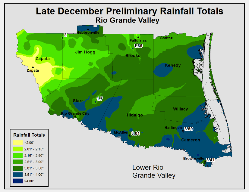 December 25 through 31 (morning) rainfall. Does not include additional light rains across the Lower and Mid Valley during afternoon and evening of New Year’s Eve. Click to enlarge. 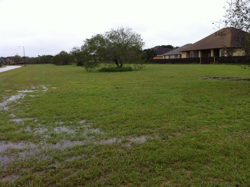 End of year photo of high standing water in fields of North Brownsville, a sign of the end of drought conditions in Cameron County |
|
||||||||||||||||||||||||||||||||||||||||||||||||||||||||||
| To Page 1 |
|||||||||||||||||||||||||||||||||||||||||||||||||||||||||||

