 |
|||||||||||||||||||||||||||||||||||||||||||||||||||||||||||||||||||||||||||||||||||||||||||||||||||||||||||||||||||||||||||||||||||||||||||||||||||||||
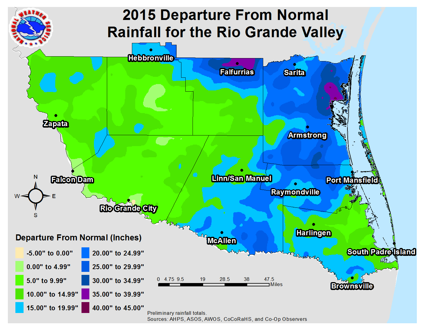 2015 Rio Grande Valley Rainfall Departure from Average (inches). |
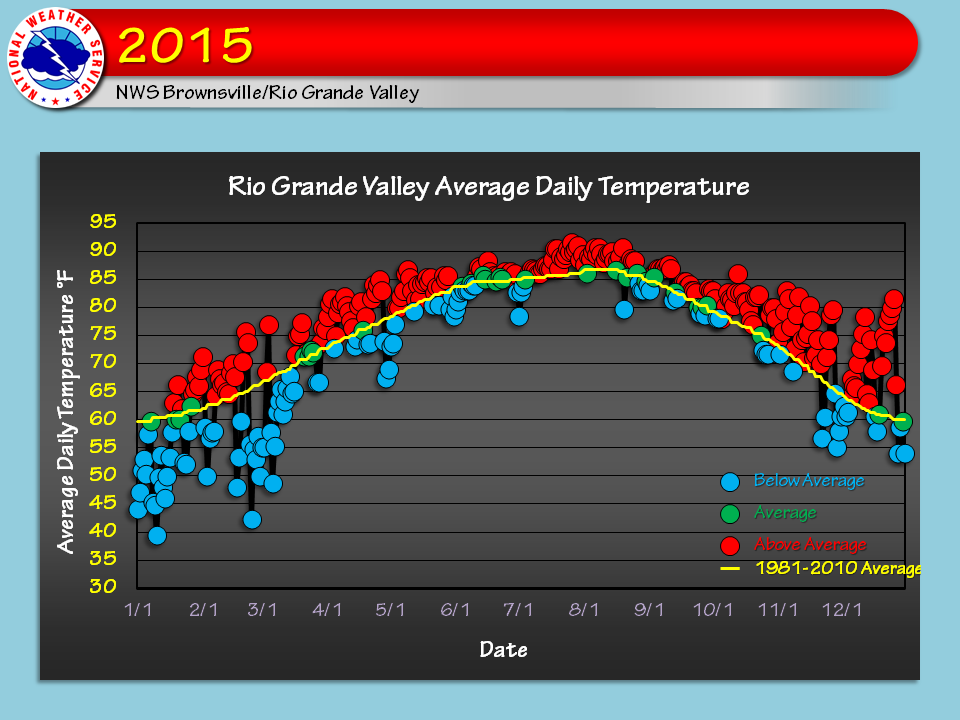 2015 Rio Grande Valley monthly average temperatures (circles) vs. the 1981-2010 30 year average (gray diamonds). Blue circles and lines indicate months with below average values; red circles/lines indicate above average values. |
||||||||||||||||||||||||||||||||||||||||||||||||||||||||||||||||||||||||||||||||||||||||||||||||||||||||||||||||||||||||||||||||||||||||||||||||||||||
*Non–calendar day cooperative observations may be slightly off at beginning and end of year.
**Rainfall totals are low due to tipping bucket undercatch. †Used Site TS999 (Airport) as proxy. |
|||||||||||||||||||||||||||||||||||||||||||||||||||||||||||||||||||||||||||||||||||||||||||||||||||||||||||||||||||||||||||||||||||||||||||||||||||||||
| Drought, Out! 2015 Brings Green and Flooding to Valley Year in Review: Wet Was the Word; Cool Start, Warm Finish Drought Eliminated with Spring Torrents and Record Rainfall |
|||||||||||||||||||||||||||||||||||||||||||||||||||||||||||||||||||||||||||||||||||||||||||||||||||||||||||||||||||||||||||||||||||||||||||||||||||||||
|
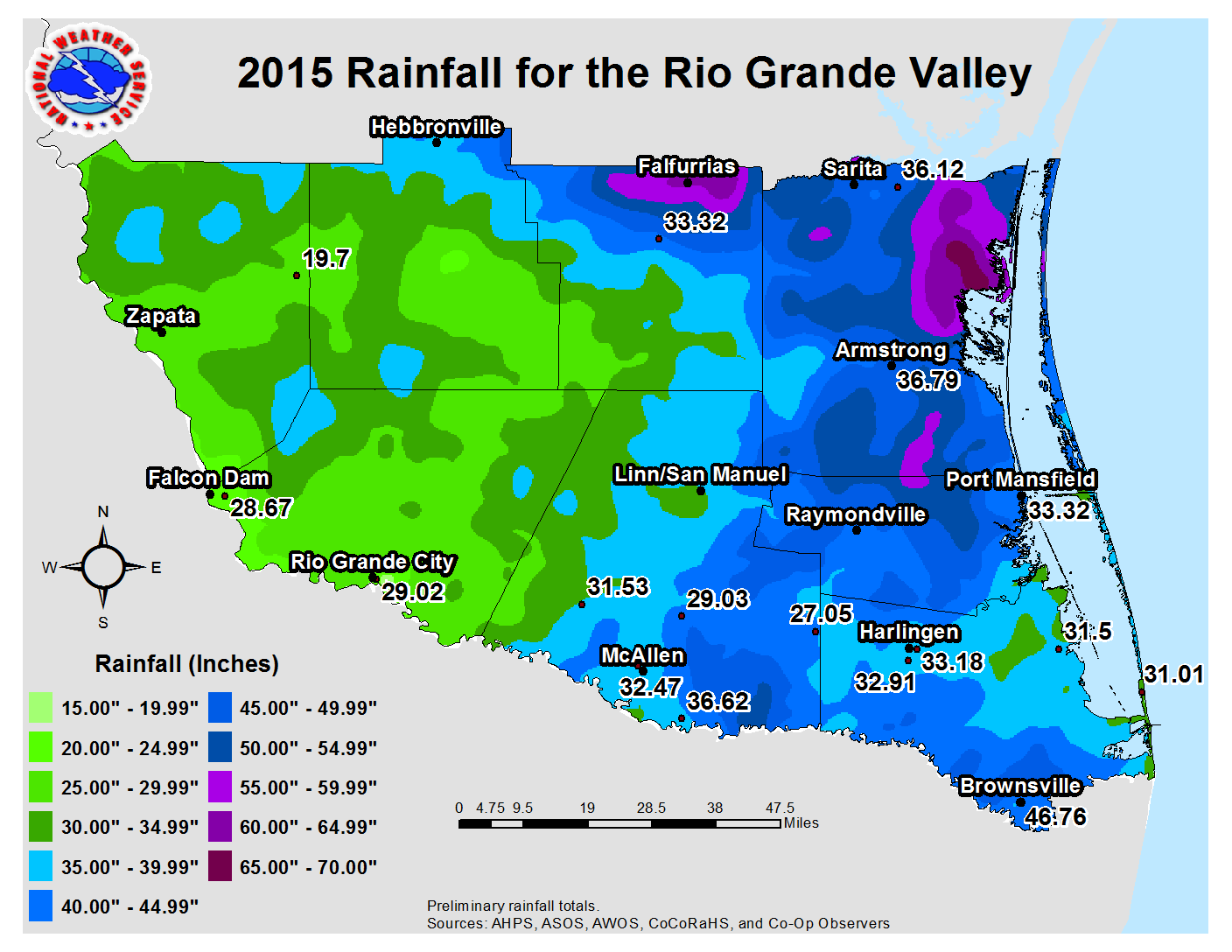
In Brief The year 2015 in the Rio Grande Valley will be at once fondly remembered as the year without a severe or greater drought (Level 2 on the U.S. Drought Monitor Classification) for the first time since 2007. For many, 2015 will also be remembered for the more than $100 million in property and crop damage from spring and fall floods. In all areas where a full set of data was available, annual rainfall ranked in the top 20 highest on record; for the highly populated areas between McAllen and Brownsville, rain totals ranked in the top ten. Occasional soaking rains affected the Valley into early March and combined with early year chill, just as El Niño was beginning to couple the ocean and atmosphere. Between late March and June, the strengthening El Niño would be just one piece of the big puzzle that brought flooding rains across much of Texas, culminating in the disastrous floods in the Hill Country prior to Memorial Day. As the rains began in earnest, latent heat (condensation) energy from warm and humid air flows from the Gulf and eastern Pacific Ocean maintained long periods of cloud cover at night which helped bring temperatures above average. By summer, El Niño’s impacts were resonating from Atlantic to Pacific, with a very busy hurricane season in the Pacific and a difficult season in the Atlantic due to persistent wind shear. In between, "La Canícula" held forth for Texas and northeastern Mexico, killing off the rain and drying out soil into early September. The rains returned in force in October, with the most significant flooding of the year across the Lower Valley. The year would close, somewhat surprisingly, much warmer than average and relatively dry, before the tables finally turned to begin 2016 on a wet and cold note. For a year at least, irrigation water receded as a critical issue as water availability was more than sufficient for most growing areas. Texas reservoir levels rose dramatically as the statewide rainfall broke an all-time annual record (more than 40 inches on average). Falcon International Reservoir, which saw less inflow when compared with smaller lakes and reservoirs elsewhere in Texas, had its highest annual capacity since 2010/2011 when the remains of Hurricane Alex were stored and slowly released. From the Lower Valley through the King Ranch, where there were pockets of rainfall surplus that exceeded 25 inches, the ground remained green and lush, and brush grew and thickened. Brownsville might have been called "Greensville" in 2015. For the year, preliminary temperatures at the three primary Valley locations were as follows:
Continue reading for a capsule of the many weather stories through 2015. Links are provided to take you to the full details of each event. |
|||||||||||||||||||||||||||||||||||||||||||||||||||||||||||||||||||||||||||||||||||||||||||||||||||||||||||||||||||||||||||||||||||||||||||||||||||||||
| January to March: Cold Start, Mild Finish; Periodic Rain | |||||||||||||||||||||||||||||||||||||||||||||||||||||||||||||||||||||||||||||||||||||||||||||||||||||||||||||||||||||||||||||||||||||||||||||||||||||||
|
Cold weather shocked the system at the start of the New Year, after a mild December 2014. Cold and occasionally wet weather brought some of the coldest measured and "feels–like" temperatures on record for the first eleven days of January. The chill would quickly fade by mid month, and early spring–like weather would close January, including several "Chamber of Commerce" days just after the Martin Luther King Jr. Holiday. A brief summary of January’s transition is found here. February was fairly non–descript, with alternating periods of cool/cold and warm. The cold snaps were stronger and a little longer than the opposite warm spells, with monthly temperatures ending up a chilly 3°F below average, punctuated by a sharp cooldown on the 23rd that never quite recovered before month’s end. A single freeze – the only one of the 2014/2015 winter – occurred across the King Ranch early on the 18th; temperatures in the 30s and 40s with wind chills ranging from the upper 20s and 30s peaked on the 24th. The transition to spring in March was slow, as winter’s chill held tough right through mid month. That chill came with substantial rainfall, up to three times the monthly average, between the 7th and 13th which enhanced the greenness but also created waterlogged soil that interrupted and some cases delayed the growing season for some crops, inclding sugar cane. A modest warm–up through the end of the month came with lighter rains, but ample cloud cover held evporation rates down. The transition to spring was completed on March 26th, when an approaching cold front activated a single, potent hail and wind producing thunderstorm that raked parts of populated Hidalgo County with quarter to golfball sized hail. The storm, occuring just three days prior to the anniversary of the March 29, 2012 destrucitive McAllen hailstorm, struck fear into many residents in the area. |
|||||||||||||||||||||||||||||||||||||||||||||||||||||||||||||||||||||||||||||||||||||||||||||||||||||||||||||||||||||||||||||||||||||||||||||||||||||||
| April to June: The Rain (and Lightning) Men Cometh | |||||||||||||||||||||||||||||||||||||||||||||||||||||||||||||||||||||||||||||||||||||||||||||||||||||||||||||||||||||||||||||||||||||||||||||||||||||||
|
Fierce lightning, flooding rain, damaging wind; April in the Rio Grande Valley had a little bit of everything for everyone as El Niño added an energy boost to an already active transition toward the increasingly warm and humid weather that defines late spring and early summer. The action started in earnest between April 10th and 17th. Torrential rains from thunderstorm clusters on the 10th produced six inches that flooded colonias north of Mission. Just two days later, a potent upper level disturbance fueled a squall line across the Rio Grande Plains that caused minor structural damage in Zapata, along with gusty winds, heavy rain, and frequent cloud to ground lightning that surged all the way through the Lower Valley. Another round of locally heavy rains dumped more than 3 inches across the Jim Hogg and Brooks County ranchlands on the 14th. The "hits" kept coming on the 23rd and 24th, first in the form of excessive lightning and torrential rains from a thunderstorm complex that oozed from Tamaulipas into Starr County late on the 23rd. The big blow happened the following evening as a microburst with winds up to 80 mph leveled scores of poorly built homes in colonias north of Weslaco and Donna, with likely more than $10 million in damage to all structures. By month’s end, rain totals ranked among the top twenty wettest all–time, ranging from 3 to 7 inches for all but the Cameron County coast, where 1 to 2 inches fell over and east of Brownsville. The influence of El Niño was in full flight. The rainy heart beat equally strong in May. Multiple events would continue to pile up the totals; by month’s end, some locations across the King Ranch had equalled or achieved annual rainfall totals, well in advance of the late summer/early fall rainy season!! After a relatively quiet start (seasonal temperatures and minimal rainfall), the action cranked up on May 11th and 12th with the Valley/Ranchlands most significant flood event of the spring. Seven to thirteen inches of rain fell in northern Hidalgo, northern Brooks, and rural Kenedy County; widespread colonia flooding ensued in the Linn/San Manuel area of Hidalgo, as well as around Falfurrias between the 12th and 15th. Big rains also slammed Hebbronville (Jim Hogg) and the Rio Grande City area; water rescues followed where several feet of water reached into homes from Rio Grande city (Starr) to Faysville (Hidalgo). Compounding the torrents and frequent to excessive lightning were microburst winds associated with the powerful thunderstorm system; these winds, up to 70 mph, caused considerable damage to poorly built or unanchored structures in the Edcouch/Elsa area just past midnight on the 12th. Two more thunderstorm systems would round out May. The first, which initially raced across the Rio Grande Plains in similar fashion to the April 12/13 event referenced above, produced more local flooding and a lightning show late on the 23rd. The initial system would weaken a bit while crossing into the Upper Valley, but would revitalize toward the coast and drop 3 to 6 inches along the coast from Brownsville to Kenedy County after midnight and into the wee hours of May 24th. Urban flooding developed in Brownsville and South Padre Island during the pre-dawn hours. A summary of the event is here. The month – and spring, would close out fittingly with multiple thunderstorm systems. The first, on May 29th, produced gusty winds and decent rains while slicing through the Rio Grande Plains and Upper Valley, but would save its bigger rains for the coast, where minor flooding occurred once again near Brownsville. Strong wind followed the rain as the system slid into the Gulf. A second event, a cluster of cells across the Upper Valley and Rio Grande Plains, dumped more than 4 inches on Rio Grande City where local flooding resumed, and at least two inches in portions of rural Starr and Jim Hogg County. The final event on May 31st slammed Brownsville, with 3.5 inches surging the monthly total to 9.72 inches, a new all-time record. The report for the final three days of a soaking May is here. The wet memories of spring 2015 were unprecedented for some. El Niño was in full swing by the end of May. El Niño, coupled with other teleconnections, including the Pacific Decadal Oscillation which was in a pronounced positive phase (assisting the unusually warm waters along the temperate U.S. Pacific coast) and a prolonged positive phase of the Arctic Oscillation, which may have contributed to the elimination of continental air mass intrusions and allowed the tropical and subtropical flow to dominate, were likely culprits in the final puzzle that contributed to new record rainfall for the season across Texas. For Rio Grande City, Brownsville, and La Joya/Mission, new seasonal rainfall records were set; other Valley locations settled into the top ten wettest springs on record. June began quietly, a welcome respite for the Valley after nearly weekly (or less) thunderstorm clusters or systems aggravated flood situations from early April until the final day of May. The quiet wouldn’t last, however. Beginning around the 15th and continuing through the 20th, the combination of a nearly stationary upper level disturbance over west and central Texas, as well as wrap–around rains from Tropical Storm Bill, produced more flooding and water rescues from the Edinburg/Pharr area through Hebbronville and Falfurrias. Up to 8 inches in several hours from repeating thunderstorms near Edinburg produced at least $23 million in insured damage on the 18th and 19th ; an estimated 6 to 12 inches across the northern tip of Jim Hogg County flooded out streets in Hebbronville late on the 17th. For a fourth month in a row, rainfall for most of Deep South Texas was above to well above average, including pockets of 500 percent of normal (8 to 12 inches above the typical 2 to 4 inches that falls in June). To Page 2 |
|||||||||||||||||||||||||||||||||||||||||||||||||||||||||||||||||||||||||||||||||||||||||||||||||||||||||||||||||||||||||||||||||||||||||||||||||||||||

