
Severe thunderstorms will remain possible in the Mid-Atlantic through Tuesday. Severe thunderstorms and heavy rain will also be possible in the central/southern Plains on Tuesday and Wednesday. Hazardous heat will linger across the southern U.S. and build across the West through mid-week. Hot and dry weather will create Elevated to Critical fire weather conditions in the Four Corners Region. Read More >
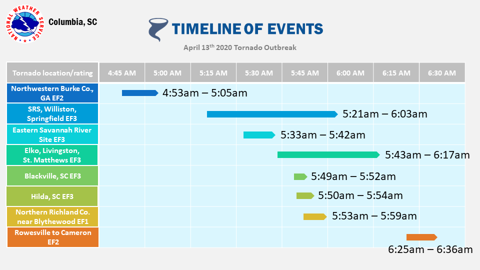
...SUMMARY OF ALL DAMAGE SURVEYS IN CENTRAL SC AND EAST-CENTRAL
GA FOR THE APRIL 13, 2020 TORNADO EVENT...

Overview: Unless new information is received, the National Weather Service
in Columbia has completed surveying the tornado damage from the April 13,
2020 tornado event. Here is a recap of all tornadoes in Central South Carolina
and East-Central Georgia.

In total, there were 5 EF-3 tornadoes, 2 EF-2 tornadoes, and 1 EF-1 tornado in
Central South Carolina and East-Central Georgia, causing 2 fatalities and at
least 7 significant injuries.
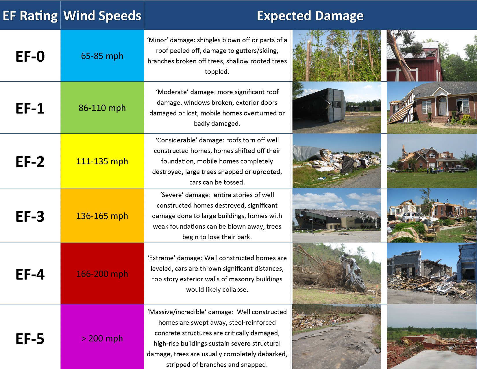
EF Scale: The Enhanced Fujita Scale classifies tornadoes into the following categories:
.png)
1. Summary of the Northwestern Burke County EF2 Tornado
| Location | Estimated Start Time | Maximum EF-Scale Rating | Estimated Maximum Wind Speed | Maximum Path Width | Path Length | Fatalities | Injuries |
|---|---|---|---|---|---|---|---|
|
Northwestern Burke County, Ga |
04:53 AM EDT |
EF2 |
125 mph |
700.0 yards |
16.94 miles |
0 |
0 |
...Northwest Burke County, Georgia EF-2 Tornado...

Start Location...6 NNE Vidette in Burke County GA
End Location...10 ESE Hephzibah in Burke County GA
Date...04/13/2020
Estimated Time...04:53 AM EDT
Maximum EF-Scale Rating...EF2
Estimated Maximum Wind Speed...125 mph
Maximum Path Width...700.0 yards
Path Length...16.94 miles
Beginning Lat/Lon...33.1066 / -82.1918
Ending Lat/Lon...33.2265 / -81.9452
* Fatalities...0
* Injuries...0

...Summary...
A tornado touched down northeast of Vidette in Burke County, GA
near Highway 80. The tornado continued in a general northeastern
direction, crossing Quaker Road, US 25, and dissipated near
Highway 56 and Collins Road. The tornado produced mainly EF-0 and
EF-1 damage along its path, but reached EF-2 intensity in several
locations with peak wind speeds of 125 mph. The tornado had a
path length of approximately 17 miles with a path width of around
700 yards.

The tornado uprooted or snapped a significant amount of trees
along its entire path. Along Highway 80, a former auto service
cinder block building had its bay doors blown in, causing the roof
to lift off and some of the block walls to collapse. Along
Coursey Road, nearly all of the pine trees snapped in a field and
a couple of houses had significant roof damage. A couple of pecan
groves had significant damage with many pecan trees snapped or
uprooted near Quaker Road and Taylor Road. West of Story Mill
Road near George Perkins Road, there were an extensive amount of
hardwood trees snapped and uprooted, with many of them falling on
a home and vehicle. Major damage also occurred at a dairy farm
along Highway 25, where metal posts supporting a canopy bent and
snapped over a feeding area, a feed shed had its roof torn off and
the metal framing bent and several other structures on the
property had significant roof damage or total roof loss.
2. Summary of the Savannah River Site to Near Williston to Springfield to Neeses EF3 Tornado
| Location | Estimated Start Time | Maximum EF-Scale Rating | Estimated Maximum Wind Speed | Maximum Path Width | Path Length | Fatalities | Injuries |
|---|---|---|---|---|---|---|---|
| Savannah River Site, Williston, and Springfield |
05:21 AM EDT |
EF3 |
140 mph |
800.0 yards |
38.28 miles |
0 |
0 |
...Savannah River Site to Williston to Springfield to Neeses
EF-3 Tornado in Aiken, Barnwell and Orangeburg Counties...

Start Location...5 W Savannah River Site in Aiken County SC
End Location...1 WNW Neeses in Orangeburg County SC
Date...04/13/2020
Estimated Time...05:21 AM EDT
Maximum EF-Scale Rating...EF3
Estimated Maximum Wind Speed...140 mph
Maximum Path Width...800.0 yards
Path Length...38.28 miles
Beginning Lat/Lon...33.2751 / -81.7048
Ending Lat/Lon...33.5408 / -81.1379
* Fatalities...0
* Injuries...0

...Summary...
A strong, long-track tornado began in the Savannah River Site
southeast of Jackson, SC, then moved in a general northeast
direction in Aiken County near the Barnwell County border. The
tornado crossed into Barnwell County northwest of Williston near
Davis Bridge Road. The tornado continued northeast across northern
Barnwell County and crossed into Orangeburg County where it passed
through Springfield and dissipated on the northwest side of Neeses.
The tornado path length was approximately 38.28 miles, and at its
widest point was just under 0.5 miles. The tornado rating was an EF-
3, with peak wind speeds of 140 mph.

Based off of high resolution imagery, radar data (including the
height debris was detected), and correspondence with Savannah
River Site officials, it has been determined that the tornado
became strong within the Savannah River Site boundaries as it moved
to the northeast. As the tornado moved out of the Savannah River
Site, it produced significant damage near Williston Road and Jaywood
Road west of Williston. In this area, significant roof damage and a
partial wall collapse to a brick house occurred, with a small cinder
block workshop destroyed. The tornado then destroyed a vacant cinder
block store building, and removed the roof and some of the walls of
a metal auto shop building. Nearby trees were all snapped near the
base. A mobile home was shifted about 6-10 feet off its foundation
along Cherry Tree Road. Along Tinker Creek Road, the tornado
destroyed a brick shed and removed most of the roof off a home,
completely destroyed a manufactured home near Charleston Highway,
and based on aerial photographs blew down a large swath of trees
east of the roadway. The tornado then crossed Charleston Highway,
removing a large portion of the roof and collapsing an exterior wall
of a business. The tornado continued to snap and uproot countless
trees as it crossed Davis Bridge Road, and New Forest Road in
northern Barnwell County. The tornado moved into Orangeburg County,
uprooting many large trees in the town of Springfield, some of which
fell on homes and one on a church. The tornado then crossed the path
of the Elko to Livingston to St. Matthews EF-3 tornado in the
vicinity of Fire Tower Road and Starwood Drive about 2 to 3 minutes
later. Several homes along Fire Tower Road had extensive roof and
front porch damage. Multiple trees were down along Ninety Six Road,
with one of them falling on a house. The tornado finally dissipated
east of Ninety Six Road just before reaching the Neeses town limits.
3. Summary of the Eastern Savannah River Site EF3 Tornado
| Location | Estimated Start Time | Maximum EF-Scale Rating | Estimated Maximum Wind Speed | Maximum Path Width | Path Length | Fatalities | Injuries |
|---|---|---|---|---|---|---|---|
|
Eastern Savannah River Site |
05:33 AM EDT |
EF3 |
138 mph |
50.0 yards |
8.55 miles |
0 |
0 |
...Eastern Savannah River Site EF-3 Tornado in Barnwell County...

Start Location...4 ENE Savannah River Site in Barnwell County SC
End Location...3 SW Elko in Barnwell County SC
Date...04/13/2020
Estimated Time...05:33 AM EDT
Maximum EF-Scale Rating...EF3
Estimated Maximum Wind Speed...138 mph
Maximum Path Width...50.0 yards
Path Length...8.55 miles
Beginning Lat/Lon...33.2754 / -81.5438
Ending Lat/Lon...33.3512 / -81.428
* Fatalities...0
* Injuries...0

...Summary...
Sentinel Satellite Data from April 13, 2020 clearly shows a
damage scar beginning at the western edge of Parr Pond in the
Savannah River Site and ending near the intersection of Highway
278 and State Road 21. A tornadic debris signature detected by the
KCAE radar aligns with the damage scar. A ground survey also
indicated a few trees down just off a field on the eastern side of
Fellowship Road as tornado dissipated. Based off of high
resolution imagery, radar data (including the height debris was
detected), and correspondence with a Savannah River Site official,
it is estimated that winds reached EF-3 strength, with speeds up
to 138 mph.
4. Summary of the Elko to Livingston to St. Matthews EF-3 Tornado in Barnwell, Orangeburg and Calhoun Counties
| Location | Estimated Start Time | Maximum EF-Scale Rating | Estimated Maximum Wind Speed | Maximum Path Width | Path Length | Fatalities | Injuries |
|---|---|---|---|---|---|---|---|
| Elko, to Livingston, to St. Matthews |
05:43 AM EDT |
EF3 |
140 mph |
770.0 yards |
36.9miles |
2 |
7 |
...Elko to Livingston to St. Matthews EF-3 Tornado in Barnwell,
 Orangeburg and Calhoun Counties...
Start Location...4 S Elko in Barnwell County SC
End Location...8 WSW St. Matthews in Calhoun County SC
Date...04/13/2020
Estimated Time...05:43 AM EDT
Maximum EF-Scale Rating...EF3
Estimated Maximum Wind Speed...140 mph
Maximum Path Width...770.0 yards
Path Length...36.9 miles
Beginning Lat/Lon...33.3158 / -81.3944
Ending Lat/Lon...33.624 / -80.9115
* Fatalities...2
* Injuries...7
...Summary...
A strong, long-track tornado began just south of the town of Elko
in Barnwell County, then moved in a general northeast direction
through Orangeburg County, before dissipating southwest of St.
Matthews in Calhoun County before reaching I-26. The tornado path
length was about 37 miles, and at its widest point was just under
0.5 miles. The tornado was rated an EF-3, with peak wind speeds
of 140 mph. There were 2 confirmed fatalities with at least 7
injured.
The tornado began near Orchard Road and Highway 37. Along its
entire path, there was widespread tree damage. The tornado snapped
7 wood power poles near US 78 and Turkey Creek. The tornado
strengthened as it approached Highway 3 and Gardenia Road, where
it destroyed and tossed a wood framed home anchored to the ground,
lifted a significant portion of a roof on a brick home, destroyed
a fifth wheel camper, and knocked over a pivot irrigation system.
The tornado then crossed Norway Road where it snapped multiple
power poles. As the tornado reached Fire Tower Road west of
Neeses, it intensified further, destroying 3 anchored manufactured
homes on Preserver Road near Ninety Six Road It was in this area
that the 2 known fatalities occurred to residents in a double-wide
manufactured home. The tornado then turned more eastward,
crossing Savannah Highway and Dragstrip Rd north of Livingston.
There were several homes or manufactured homes that were heavily
damaged or destroyed in this area. The tornado gradually weakened
as it crossed North Road and dissipated as it crossed into Calhoun
County.
5. Summary of the Blackville EF3 Tornado
| Location | Estimated Start Time | Maximum EF-Scale Rating | Estimated Maximum Wind Speed | Maximum Path Width | Path Length | Fatalities | Injuries |
|---|---|---|---|---|---|---|---|
|
Blackville, SC |
05:49 AM EDT |
EF3 |
140 mph |
40.0 yards |
1.38 miles |
0 |
0 |
...Blackville EF-3 Tornado in Barnwell County...

Start Location...3 S Blackville in Barnwell County SC
End Location...2 S Blackville in Barnwell County SC
Date...04/13/2020
Estimated Time...05:49 AM EDT
Maximum EF-Scale Rating...EF3
Estimated Maximum Wind Speed...140 mph
Maximum Path Width...40.0 yards
Path Length...1.38 miles
Beginning Lat/Lon...33.3177 / -81.2903
Ending Lat/Lon...33.3369 / -81.2833
* Fatalities...0
* Injuries...0

...Summary...
A tornado started just south of Blackville, SC east of Whitehall
Drive near Toby Creek. The tornado damaged several chicken houses
by causing the walls to collapse in a few places. The tornado
then moved northeast crossing a large empty field, before
intensifying as it approached a fiberglass coating facility near
Lake Cynthia Road. The tornado collapsed a large segment of a 75
ft tall, 150 ft x 150 ft warehouse, with large steel support beams
twisted. 30 cylindrical containers weighing up to 20- 25 thousand
pounds each lifted out of their u-shaped saddles and rolled
throughout the facility. There was evidence of very minimal tree
damage east of Blackville but not enough damage to suggest the
tornado track continued that far north. As a result, the tornado
likely lifted prior to reaching Highway 3. The tornado path length
was just under 1.5 miles and had a width of about 40 yards. The
tornado was rated EF-3, with peak winds of 140 mph.
6. Summary of the Hilda EF3 Tornado
| Location | Estimated Start Time | Maximum EF-Scale Rating | Estimated Maximum Wind Speed | Maximum Path Width | Path Length | Fatalities | Injuries |
|---|---|---|---|---|---|---|---|
|
Hilda, SC |
05:50 AM EDT |
EF3 |
145 mph |
800.0 yards |
5.45 miles |
0 |
0 |
...Hilda EF-3 Tornado in Barnwell County...

Start Location...5 S Hilda in Barnwell County SC
End Location...1 E Hilda in Barnwell County SC
Date...04/13/2020  Estimated Time...05:50 AM EDT
Maximum EF-Scale Rating...EF3
Estimated Maximum Wind Speed...145 mph
Maximum Path Width...800.0 yards
Path Length...5.45 miles
Beginning Lat/Lon...33.2071 / -81.2742
Ending Lat/Lon...33.2715 / -81.2223
* Fatalities...0
* Injuries...0

...Summary...
A tornado touched down in far southeast Barnwell moving
northeastward toward the Bamberg county line southeast of the
town of Hilda, briefly intensifying to a strong tornado along
Hartzog Road. The tornado length was 5.5 miles and had a width of
800 yards at its widest point. The tornado was rated EF-3, with
peak winds of 145 mph.

The tornado began just north of Highway 64 at Green Branch Road
near Indigo Road. The tornado moved northeast across Hercules
Creek and caused significant tree damage at a residence on
Friendship Road. Several oak and pine trees were uprooted and
snapped. A cinder block garage had its metal roofing peeled off
and the wind stress shifted the cinder blocks about half way up
the wall. Along its northeastward path, there was continued tree
damage but the tornado strengthened rapidly as it crossed Hartzog
Road just south of November Road. A well built bolted down metal
building structure and tin tractor shed was completely destroyed.
Further north along Hartzog Road, a residence had part of its roof
lifted off and behind the residence, a two story wood frame
building was shifted off its foundation and destroyed and an
unanchored log cabin was destroyed. As the tornado moved
northeast toward Huckleberry Bay Road there were multiple hardwood
trees snapped near the base of the trees. The tornado began to
weaken as it crossed Old Salem Road continuing to damage trees
along its path before dissipating just north of Huttos Chapel
Road.
7. Summary of the Northern Richland County east of Blythewood EF1 Tornado
| Location | Estimated Start Time | Maximum EF-Scale Rating | Estimated Maximum Wind Speed | Maximum Path Width | Path Length | Fatalities | Injuries |
|---|---|---|---|---|---|---|---|
|
Northern Richland County east of Blythwood |
05:53 AM EDT |
EF1 |
105 mph |
80 yards |
4.91 miles |
0 |
0 |
...Northern Richland County EF-1 Tornado near Blythewood...

Start Location...5 SE Blythewood in Richland County SC
End Location...6 WNW Elgin in Richland County SC5 SE Blythewood in Richland County SC
Date...04/13/2020
Estimated Time...05:53 AM EDT
Maximum EF-Scale Rating...EF1
Estimated Maximum Wind Speed...105 mph
Maximum Path Width...80.0 yards
Path Length...4.91 miles
Beginning Lat/Lon...34.1556 / -80.919
Ending Lat/Lon...34.2157 / -80.8738
* Fatalities...0
* Injuries...0

...Summary...
A strong EF-1 tornado began near the intersection of Lee Road and
Trowbridge Road. The tornado continued northeast for just under 5 miles.
The tornado crossed Hard Scrabble Road, Kelly Mill Road, Langford Road
and dissipated near Heins Road. The maximum estimated wind speed
associated with the tornado was 105 mph.

Much of the damage along the path of the tornado was tree damage. There
were numerous trees that had been snapped, uprooted or suffered damage
to branches. There were several homes that suffered minor roof damage
to roofing materials, such as shingles, along with damage to soffit and
fascia on the exterior of structures. Some of the most extensive tree
damage occurred just off of Langford Road near the Hunters Run
neighborhood. There were also several large trees, both hardwood and
softwood, that were snapped and uprooted along Kelly Mill Road near
the Crickentree neighborhood. This is across the street from Lake Carolina
Elementary Upper Campus. Along Ejw Road, across the street from Lake
Carolina Elementary Lower Campus, there were several trees that has fallen
across the roadway and been cleared. Additionally, along Ejw Road, there
were a few trees either snapped, uprooted or with significant branch damage
before the road crossed Round Top Branch. Several trees were uprooted along
the entrance to Crickentree on Crickentree Drive.
8. Summary of the Rowesville to Near Cameron EF2 Tornado
| Location | Estimated Start Time | Maximum EF-Scale Rating | Estimated Maximum Wind Speed | Maximum Path Width | Path Length | Fatalities | Injuries |
|---|---|---|---|---|---|---|---|
|
Rowesville and Cameron |
06:25 AM EDT |
EF2 |
119 mph |
700.0 yards |
10.29 miles |
0 |
0 |
...Rowesville to Cameron EF-2 Tornado in Orangeburg and Calhoun
Counties...

Start Location...3 NE Rowesville in Orangeburg County SC
End Location...4 SE Cameron in Calhoun County SC
Date...04/13/2020
Estimated Time...06:25 AM EDT
Maximum EF-Scale Rating...EF2
Estimated Maximum Wind Speed...119 mph
Maximum Path Width...700.0 yards
Path Length...10.29 miles
Beginning Lat/Lon...33.4032 / -80.787
Ending Lat/Lon...33.5123 / -80.6716
* Fatalities...0
* Injuries...0

...Summary...
A tornado touched down in Orangeburg County about 4 miles
northeast of Rowesville and tracked northeastward across
Interstate 26 and Highway 301. EF0 damage occurred from the
intersection of Garland and Bethel Forest Road, where the tornado
started, to just prior to crossing I-26. The tornado strengthened
producing EF-1 damage across agricultural fields and in the
Orangeburg Industrial Park. As the tornado crossed I-26 it
further strengthened to EF-2 then crossed Highway 301. The
tornado rapidly weakened to EF-1 then just north of Highway
301 and further to EF-0 as it moved into the Middle Pen Swamp.
Through the remainder of the tornado path it cycled between EF-1
and EF-0 then finally lifted just north of the intersection of
Houcks Gin Road and Old State Road. The total tornado path length
was 10.3 miles with a maximum width of 700 yards.The tornado
caused numerous hardwood and softwood trees to be snapped along
the path and overturned multiple pivot irrigation systems. Damage
was done to a tractor dealership with the front windows being
shattered and the overhead doors being blown in by the wind.
Several of the snapped and uprooted trees were blown onto
structures causing roof damage to residential and industrial
structures. Damage to grain silos and outbuildings on the north
side of Highway 301 was estimated by the owner to be $1 million.

